
 Portuguese
  Spanish
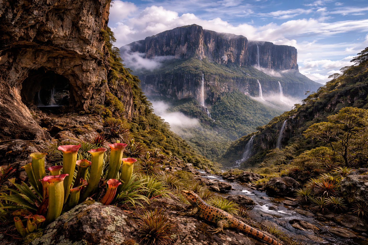
Precambrian Formation Between Brazil, Venezuela, and Guyana Preserves Unique Ecosystems, Includes Rare Caves in Quartzite, and Maintains Sacred Traditions for Indigenous Peoples
Precambrian formation between Brazil, Venezuela, and Guyana preserves unique ecosystems, includes rare caves in quartzite, and maintains sacred traditions for Indigenous peoples.
One of the oldest geological formations on the planet rises at the border between Brazil, Venezuela, and Guyana and continues to intrigue scientists and explorers.
The Roraima Mount is part of the tepui group — a term from the Pemón people meaning “house of the gods” — and began its formation between 1.7 and 2 billion years ago, still in the Precambrian period, as indicated by widely recognized geological studies.
-
Brazilian Innovator Transforms 1962 Mercury Comet with Nissan Leaf Electric Motor, Achieving 125 km Range for Under $6,000

-
China Tests Giant 582-Ton Magnets to Contain Plasma Hotter Than the Sun’s Core, Aiming to Cut Superconductor Costs and Generate First Electricity from “Artificial Sun” by 2030
-
Seventh Grader Builds Nuclear Fusion Machine at Home, Aiming for Guinness World Record

-
Ancient Ritual Circle, Hidden for 5,000 Years, Discovered in Scotland’s Machrie Moor Using Sensors, Revealing a “Phantom Stonehenge”


With vertical walls exceeding 1,000 meters and a flat top frequently shrouded in clouds, the massif maintains a natural isolation that shapes evolutionary processes for millions of years.
Geological Formation and Precambrian Origin

According to scientific descriptions released by NASA, the mountain emerged from a vast sedimentary plateau that covered much of northern South America.
Over hundreds of millions of years, erosion fragmented this structure and isolated large rocky blocks, forming natural mesas known as tepuis, composed mainly of sandstone and quartzite, extremely resilient rocks.
This geographical isolation creates a phenomenon similar to that of oceanic islands and allows ecosystems to evolve independently from the surrounding environment.
Unique Biodiversity and Endemic Species
Although savannas and areas of the Amazônia rainforest surround the mountain, the summit presents its own environmental conditions, with heavy rainfall, relatively low temperatures, and nutrient-poor soil.
These characteristics favor the development of highly adapted species, and about one-third of the vegetation of the tepuis occurs exclusively in this region of the planet.
Additionally, carnivorous plants capture insects to compensate for the soil’s nutritional scarcity, while reptiles, amphibians, and invertebrates follow their own evolutionary paths over millions of years.
Rare Caves and Water-Scarved Landscape
Water has shaped the surface of the plateau over millennia, creating caves, dark rock formations, and watercourses that descend from the summit.
In some tepuis of the region, researchers have identified cave systems formed in quartzite, a type of rock rarely associated with cave formations.
These characteristics enhance scientific interest and reinforce the unique geological value of Roraima Mount.
History, Culture, and Influence in Literature
The Indigenous peoples of the region consider Roraima Mount a sacred site and associate it with the origin of the world in their traditions.
In 1884, British explorer Everard im Thurn led the first recorded expedition to the summit, an event that broadened international scientific interest in the site.
Later, in 1912, writer Arthur Conan Doyle published the novel The Lost World, inspired by the idea of an isolated plateau with prehistoric species, and many scholars also associate the tepuis with the settings of the Disney film Up.
Environmental Protection and Trekking Tourism
Currently, three countries protect Roraima Mount through conservation areas.
In Brazil, the Roraima Mount National Park was established in 1989, by decree of then-president José Sarney, aimed at preserving the ecosystems of the Pacaraima Mountains, while Venezuela maintains the area under the Canaima National Park, recognized as a World Heritage Site by UNESCO.
In Guyana, regional authorities have established specific protection zones, and additionally, the site has consolidated as a trekking destination, with trails leading to the summit at 2,810 meters in height in expeditions lasting between seven and nine days.
Given its geological, ecological, and cultural relevance, Roraima Mount remains one of the most emblematic natural landscapes in South America.
Countries and local communities join efforts to preserve this ancient formation and balance environmental conservation with responsible tourism.
What Should Guide the Future of Roraima Mount: Expand Adventure Tourism or Strengthen Environmental Protection Strategies Even Further?


Soy Venezolana! I’m sorry to hear that Roraima is in between country, well let me tell you don’t know nothing of terrestrial VENEZUELA NOS PERTENECE AS A WHOLE, DID YOU GET.IT!! WE DON’T SHARE IT!!
Muito lindo esse monte Roraima ainda vou visitar se Deus quiser.
Fortalecer as estratégias de proteção ambiental.