
 Portuguese
  Spanish
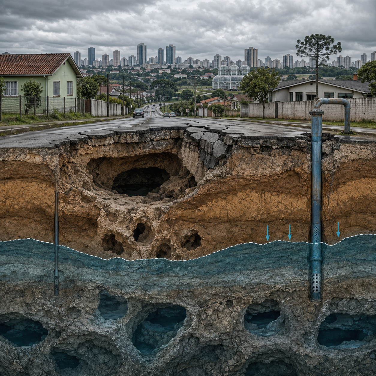
Curitiba region faces silent geological risk with subterranean cavities, land subsidence, and impact of aquifer pumping.
According to the Brazilian Association of Groundwater, the extraction of water from the karst aquifer through 11 wells located in the basins of the Fervida and Tumiri rivers, in the municipality of Colombo, Paraná, caused subsidence and land collapses in various points of the region. These events resulted in structural damage to homes, formation of depressions in the soil, cracks in urban roads, and drying up of natural springs used for domestic and agricultural supply.
The pressure exerted by affected residents led to the interruption of pumping at different times, but without a definitive solution to the problem.
History of subsidence in Almirante Tamandaré reveals continuous advancement of geological instability
Since 1992, the municipality of Almirante Tamandaré, also situated over the same karst formation, has recorded episodes of land subsidence.
-
Largest Mechanical Dredger in the Western Hemisphere Removes Nearly 80 Cubic Meters of Mud Per Cycle, Measures 77 Meters, and Operates Day and Night to Prevent Giant Ships from Getting Stuck in the Houston Ship Channel

-
California Opens Floodgates to Restore Wetlands and Create Natural Flood Protection in the Central Valley

-
US Mayor Goes Undercover as Homeless for a Week to Understand Rising Homelessness, Sparking Debate in His City

-
Teen from Brazil Turns School Snack Sales into Million-Dollar Confectionery Business Projected to Earn Nearly $1.9 Million in 2024


These events caused cracks in buildings, tilting of structures, and reduction of water levels in wells and lakes. In 2005, the Public Prosecutor’s Office set a five-year deadline for Sanepar to deactivate exploration wells in the city center, pointing out the relationship between pumping and structural damage in at least twenty buildings.
The deadline was partially met, but the geological effects persisted.
Geological formation of karst in Paraná explains presence of subterranean cavities in limestone rocks
The Metropolitan Region of Curitiba is situated over an extensive area of carbonate rocks belonging to the Capiru Formation, of the Açungui Group.
These rocks were formed between 600 and 900 million years ago, in a shallow marine environment. Over time, they underwent folding, metamorphism, and uplift, becoming exposed at the surface.

The continuous action of water on these rocks promotes their dissolution, forming subterranean cavities of different dimensions. This process is known as karstification.
Karstification process dissolves rocks over millennia and creates invisible galleries beneath urban areas
Rainwater, when infiltrating the soil, absorbs carbon dioxide and forms weak carbonic acid. This chemical compound reacts slowly with limestone, dissolving the rock over thousands of years.
The result is the formation of fissures, tunnels, and subterranean cavities that can vary from millimeters to dozens of meters. This process occurs continuously and silently, without visible signs on the surface until a collapse occurs.
Karst area north of Curitiba covers about 100 km² and sustains entire cities without residents knowing
The Paraná karst north of the Metropolitan Region of Curitiba occupies an area of approximately 100 km², mainly concentrated in the municipalities of Colombo and Almirante Tamandaré.
This region is cut by geological structures that compartmentalize the aquifer, creating distinct zones of groundwater circulation.
The subsoil exhibits behavior similar to a system with multiple cavities, with irregular distribution and difficult to fully map.
Urban growth without geotechnical study exposes thousands of residents to invisible risks below ground
The urban expansion of municipalities such as Almirante Tamandaré intensified from the 1960s, driven by the expansion of Curitiba.

A large part of the occupations occurred in areas with lower real estate value, often coinciding with geologically fragile zones.
The lack of a requirement for detailed geotechnical studies for residential constructions contributed to the occupation of risk areas without knowledge of subsoil conditions.
Intensive aquifer pumping reduces underground pressure and can cause soil collapse
Groundwater extraction alters the internal balance of the aquifer. When the water level is reduced by intensive pumping, the hydrostatic pressure supporting the underground cavities decreases.
Without this support, natural structures can collapse, resulting in land subsidence and damage to surface constructions.
Structural damage includes cracks, foundation settlement, and drying of natural springs
Observed effects include cracks in walls, building tilt, and foundation settlement. Furthermore, the reduction in aquifer levels compromises the flow of natural springs and watercourses, directly affecting local supply and agriculture.
These impacts have been recorded recurrently in recent decades. The region’s aquifer has high-quality water, with low treatment costs, being one of the main supply sources for the Curitiba Metropolitan Region.
On the other hand, its excessive exploitation compromises soil stability and increases the risk of collapses.
Projections indicate that reduced aquifer use could lead to a supply deficit in the region, creating a dilemma between geological safety and water needs.
Geophysical methods like electrical resistivity allow mapping cavities before collapse
Researchers use techniques like electrical resistivity to identify variations in the subsoil. The method measures the electrical resistance of the terrain, allowing the identification of areas with water presence, clay material, or underground voids.
This information can guide decisions on urban occupation and risk prevention. Despite the effectiveness of geophysical techniques, their use is still limited.
The high cost and lack of legal requirement prevent their large-scale application in urban planning. In most cases, studies are only conducted after damage has occurred.
Urban expansion continues to advance over karst areas without integration with geological planning
The expansion of Colombo and Almirante Tamandaré continues to occur over areas with karst presence.
Road axes such as Rodovia dos Minérios and Rodovia do Calcário concentrate this growth, coinciding with zones of greater geological vulnerability. The lack of integration between urban planning and geological knowledge increases the risks.
More than 350,000 people live on active karst areas without knowledge of underground risks
The municipalities of Colombo and Almirante Tamandaré together have over 350,000 inhabitants living on areas with underground cavities.

A large part of this population is unaware of the geological nature of the land where they reside. The lack of information and specific public policies contributes to the maintenance of an invisible risk.
The case of the Curitiba Metropolitan Region highlights a complex challenge between the exploitation of water resources and geological stability.
In your view, is it possible to balance these two factors, or does the current model tend to increase risks over time?


