
 Portuguese
  Spanish
Weather change advances through the Center-South and reinforces monitoring of rain, instability, and atmospheric variation in different regions of the country, in a week marked by the combined action of meteorological systems over areas where June usually records more limited climatic behavior.
The second extratropical cyclone expected to influence Brazil this week is expected to form on Friday (12), after a low-pressure area moves to the ocean, near the coast of the Southern Region.
Integrated into a sequence of instabilities, the system is expected to cause rain in 10 states in the Center-South, according to Meteored, with impacts expected in the South, Southeast, and part of the Midwest.
The weather change began to gain strength between the beginning and middle of the week, due to the action of instability areas, cold fronts, and low atmospheric pressures over the country.
-
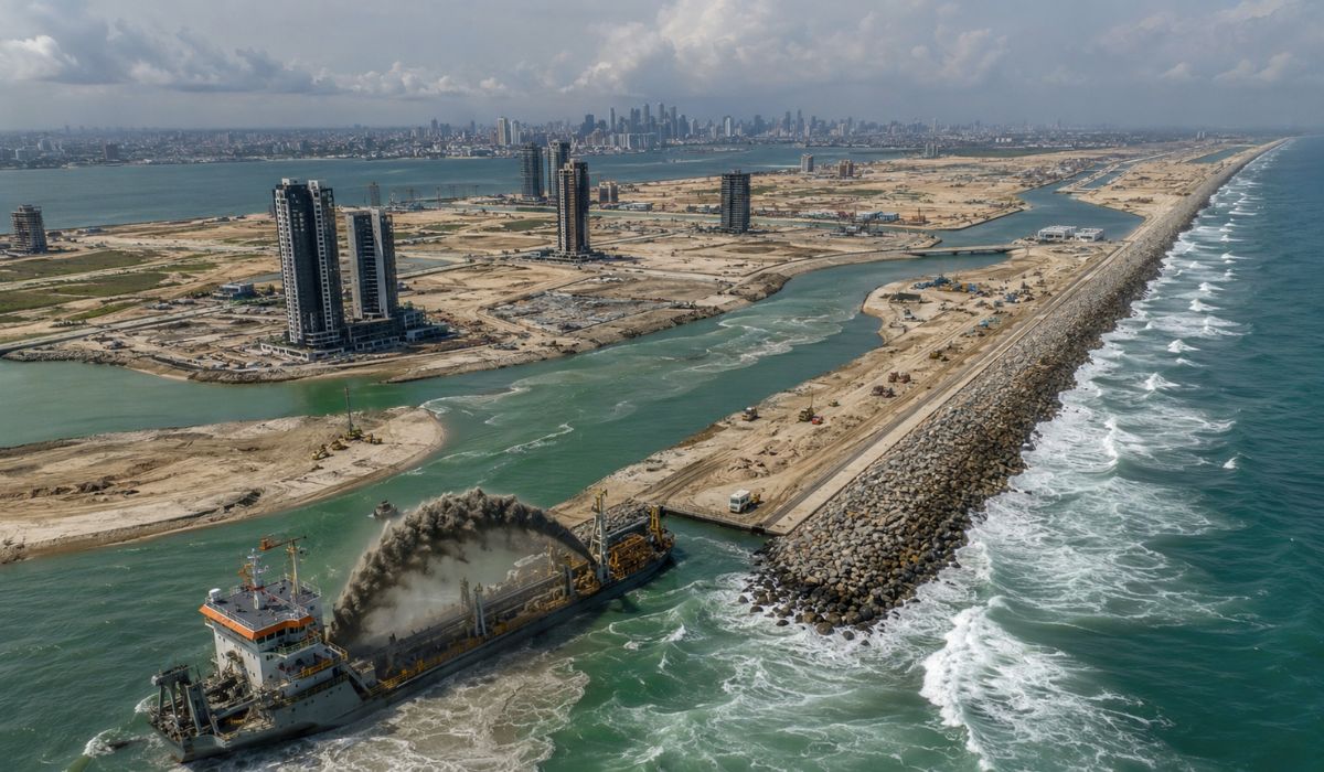
Nigeria Dumps 120 Million Tons of Sand into Atlantic to Build Massive City with 8.4 km Sea Wall for Protection Against Ocean Waves and Erosion

-
German Engineer Developed Diesel Engine Running on Vegetable Oil Decades Before Electric Cars Became Popular; Can This Forgotten Idea Work in 2026?

-
James Webb Telescope Uncovers Unexpected Clues on Mysterious Moon, Potentially Redefining Planetary Origins

-
$1.5 Billion Sleipnir Vessel Transforms Ocean into Floating Construction Site with 12 Hybrid Engines and Capacity to Lift 20,000 Tons


According to Inmet, the week of June 8 to 15, 2026, is forecasted to have rain in the Southern Region throughout the period, as well as precipitation in São Paulo, southern Minas Gerais, and Rio de Janeiro between June 11 and 13, associated with the passage of a cold front.
Extratropical cyclone changes the weather in the Center-South
The first extratropical cyclone of the week originated from a low pressure that acted over Rio Grande do Sul and moved to the ocean on Tuesday (09).
Even without indication of great potential for disruptions due to the wind, according to the forecast consulted, the system helped reorganize humidity and paved the way for a new unstable area between Mato Grosso do Sul and Paraguay.
On Wednesday (10), this new region of instability began to strengthen over the Center-South of the country, increasing the condition for rain in areas already under the influence of the change in the atmospheric pattern.
The forecast indicated moderate to heavy rain in the south of Mato Grosso do Sul, northwest of Paraná, and west of São Paulo, with risk of storms especially in southern Mato Grosso do Sul areas.
During Thursday (11), the formation of a low pressure over the Center-South increases the potential for rain in different areas, according to the meteorological data available for the period.
The risk is concentrated in the north and northwest of Rio Grande do Sul, west of Santa Catarina, west and north of Paraná, Mato Grosso do Sul, south of Mato Grosso, and sectors of São Paulo.
Second system gains strength on Friday
Starting Friday (12), the low pressure is expected to move to the ocean and give rise to the second extratropical cyclone of the week, according to the cited weather forecast.
In the early morning and morning, the system remains close to the southern Brazilian coast, a condition that favors moderate to heavy rain in the east of Rio Grande do Sul, central-east of Santa Catarina, east of Paraná, and in areas of the north, center, and east of São Paulo.
The circulation associated with the system also favors the organization of a cold front, which should alter weather conditions in parts of the Southeast and Midwest throughout Friday.
Although the front is classified as weak in intensity by the forecast, it should be sufficient to cause isolated showers in the south of Goiás, north of Mato Grosso do Sul, and central-south of Mato Grosso.
Throughout Friday, the cyclone tends to mature and attract moisture into its circulation, which changes the distribution of rain areas over the Central-South of the country.
With this reorganization, the rain loses strength in part of the Southern Region, while the cold front associated with the system advances to new areas and maintains instabilities over the Southeast.
Rain above the standard expected for June
Meteored points out that the expected rain pattern for the week is atypical for this time of year in the Central-South of Brazil, considering the climatology of June.
At this time of year, part of the affected areas usually records drier weather, especially in the interior of the Southeast and Midwest, which makes the predicted accumulations above the average behavior of the period, according to the cited meteorological evaluation.
In São Paulo, the forecast indicates that volumes may reach 100 mm by the weekend in areas of the interior and northwest of São Paulo.
The condition was associated with the action of a new cold front, which should increase the risk of storms and wind gusts in part of the Southeast Region.
Inmet also predicts significant accumulations in the Southern Region, with the possibility of up to 150 mm in the northwest of Rio Grande do Sul throughout the week.
For the Midwest, the institute indicates spotty rains and low accumulations, with possible precipitation in the northwest of Mato Grosso and central-south of Mato Grosso do Sul.
States in the area of influence of the cyclone
Altogether, the combined effects of the instabilities, the cold front, and the second cyclone are expected to reach 10 states, as described in the meteorological forecasts’ area of influence.
In the South, the weather change involves Rio Grande do Sul, Santa Catarina, and Paraná, with a risk of more intense rain between Thursday (11) and Friday (12) in specific areas of the three states.
In the Southeast, São Paulo is expected to concentrate part of the largest forecasted volumes, while Minas Gerais, Rio de Janeiro, and Espírito Santo enter the cold front’s area of influence throughout Friday.
In Minas, the rain is expected to mainly affect areas in the south-central region, Triângulo Mineiro, and later, the northeast of the state, as the system associated with the cold front advances.
In the Midwest, Mato Grosso do Sul, Mato Grosso, and Goiás appear in the area of instability associated with the system, but with significant differences in the intensity forecasted for each area.
Even so, Inmet’s forecast is more cautious for the region, indicating isolated precipitation and low accumulations during the week, with more stable weather in Goiás and the Federal District.
The combination of cyclones, low pressure, and a cold front is expected to keep the atmosphere more unstable in the Central-South until the end of the week, according to the consulted forecasts.
Even with differences between the scenarios forecasted by region, meteorological agencies and services indicate the possibility of heavy rain, isolated storms, wind gusts, and localized disruptions in urban areas and highways.


