
 Portuguese
  Spanish
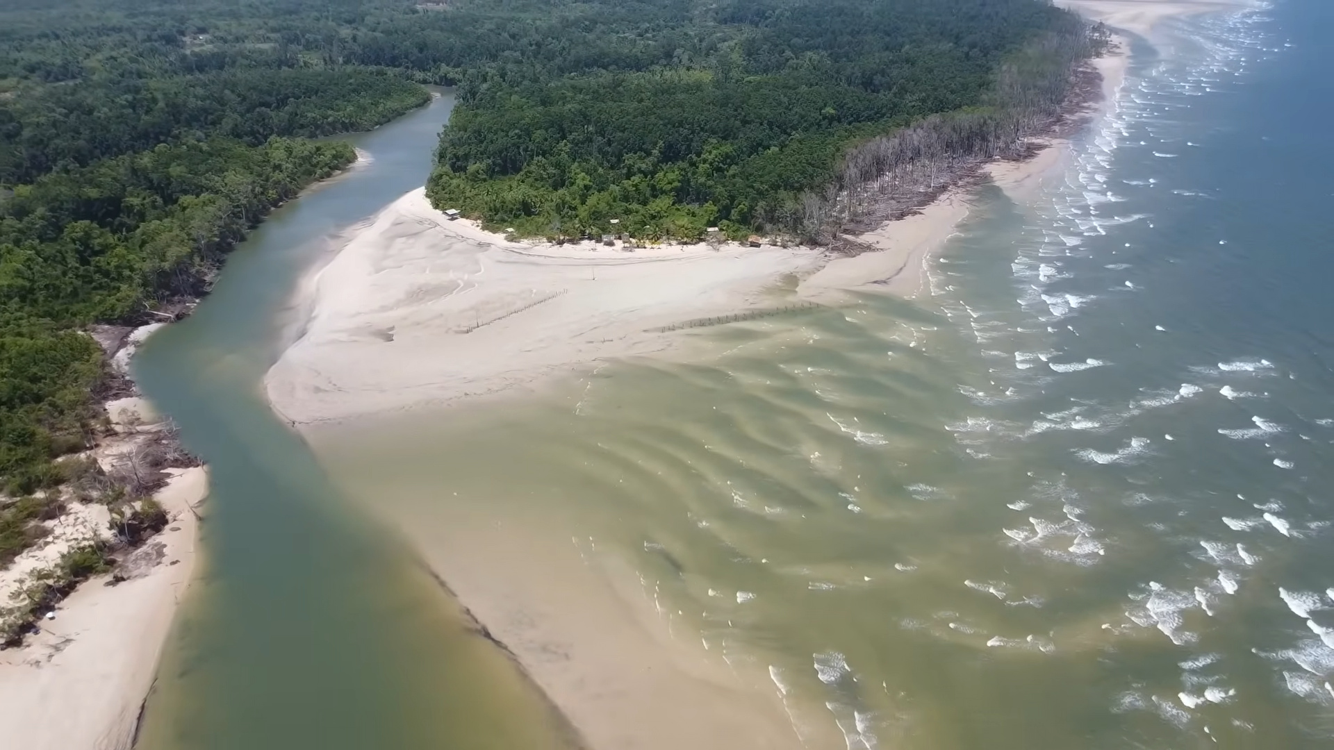
Marajó Island is losing land, suffering from aquifer salinization, and facing a risk of collapse due to sea-level rise and climate change.
According to the United Nations in Brazil, in Vila do Pesqueiro, a traditional community of 160 families located on the coast of Soure, on the eastern shore of Marajó Island, the advancing sea is no longer a projection but a physical reality. The place where houses once stood is now submerged. Residents who lived for decades in stilt houses have watched the sea progressively advance until it reached their homes. The process has been gradual, with increasingly strong tides and constant erosion reshaping the coastline.
Vila do Pesqueiro is not an isolated case. It is the most documented example of a phenomenon occurring simultaneously in several communities on the island.
Marajó Island is the world’s largest fluvio-marine island, and its geographical position defines its extreme vulnerability
Marajó Island covers approximately 49,000 square kilometers, making it larger than countries like Switzerland and Denmark.
-
Europe Sizzles: Intense Heatwave Disrupts Daily Life, Closes Schools, Strains Power Grids, and Raises Concerns Over Potential Deaths

-
Ohio Carpenter Finds 308-Gram Meteorite the Size of a Baseball After Dreaming of Its Location
-
Chinese Humanoid Robots Transition from Labs to Real Factories to Assemble Tablets: AgiBot Deploys G2 Machines at Longcheer, Aiming for 100 Robots in Electronics, Cars, Chips, and Energy by 2026
-
College Dropout Turned Window Cleaner Builds $1 Million Cleaning Business with Subscription Model After 18 Years of Door-to-Door Work


Classified as the largest fluvio-marine island on the planet, it was formed at the interface between the Atlantic Ocean and the Amazon River estuary. This geographical position, which has historically supported its biodiversity and cultural richness, has now become its main vulnerability factor.
With an average altitude of about 9 meters above sea level, the island is highly sensitive to variations in ocean levels and hydrological regimes.
Macrotide dynamics on the eastern coast of Marajó cause intense erosion and forced redistribution of sediments
On the island’s eastern coast, regions like Soure and Salvaterra are subject to macrotides with an amplitude of up to 4 meters, among the largest in Brazil.
These cycles of flooding and exposure constantly reshape the coastline. In some areas, the coast has advanced by up to 100 meters due to sediment deposition. In others, it has retreated by up to 80 meters due to erosion.
This asymmetry is not random. It reflects a loss of balance in the coastal sedimentary system, with a forced redistribution of materials along the coast.
Amazon floods combined with high tides increase flooding periods in the várzea floodplain fields
On the western side of the island, the dynamics are dominated by the Amazon estuary. The Amazon River’s flood and ebb regime raises and lowers the water level seasonally, creating cycles known as the Amazonian winter and summer.

When the flood coincides with high tide and intense rainfall events, large areas of the island remain submerged for months.
This behavior has always been part of the ecosystem’s natural functioning. What has changed is the intensity and frequency of these events.
Satellite images show systematic coastline retreat and advancing erosion in Marajó communities
Multitemporal analyses of Landsat images between 1990 and 2023 have documented a continuous linear retreat of the coastline in communities like Jubim, in the municipality of Salvaterra.

The study identified a persistent erosive trend in lower-altitude areas, where mangroves are retreating and beaches are advancing over natural structures that once protected the coast.
In Pará, about 60% of the 562 kilometers of coastline are under active erosion, indicating a scenario of widespread instability.
Exposure of Mangroves Accelerates Coastal Collapse by Eliminating Natural Barrier Against Wave Energy
Erosion removes the upper layers of soil and exposes old mangrove structures. When this occurs, the roots of these formations lose support and collapse, eliminating the main natural barrier against wave action.
Without this protection, the erosive process intensifies, creating a cycle of progressive degradation.
Salinization of Aquifers Advances Invisibly and Compromises Freshwater Supply in Communities
While erosion is visible, salinization occurs silently. The intrusion of saltwater into coastal aquifers displaces the available freshwater. Wells that once provided drinking water now produce brackish or non-potable water.
This process is slow but difficult to reverse, especially in regions with low water recharge. The decrease in freshwater flow in the Amazonian system intensifies the advance of saltwater.

Dams built along the basin reduce the volume of water reaching the ocean, especially during dry periods.
With less freshwater pressure, the sea advances more easily over riverbeds and underground aquifers.
Municipality of Afuá Shows Maximum Climate Vulnerability Index in All Projected Scenarios
A study conducted by the Federal Institute of Pará assessed the vulnerability of coastal municipalities to climate change.
Afuá, a city of about 40,000 inhabitants built on stilts, reached the maximum vulnerability index in all analyzed scenarios.
The city’s urban structure was adapted to past natural cycles but faces difficulties in the face of new climatic conditions.
Sea-Level Rise Could Make Entire Cities on Marajó Unviable in the Coming Decades
Projections based on IPCC data indicate that the increase in global temperature could significantly raise sea levels.
In areas with low average altitude, such as Marajó, even small rises represent a direct risk of permanent flooding. Entire cities may face loss of territory and the need for population displacement.

Models developed by international institutions show that large areas of the island could be affected by increasing periodic flooding in the coming decades.
In high-emission scenarios, there is a risk of permanent submersion of entire regions by the end of the century. The scale of the impact involves hundreds of thousands of inhabitants distributed across several municipalities.
Absence of Specific Public Policies Keeps Marajó Out of the Center of the National Climate Debate
Despite its evident vulnerability, Marajó Island does not hold a central position in public policies for climate adaptation.
The National Adaptation Plan identifies the coast as a priority area, but concrete actions are concentrated in large urban centers.

Traditional communities on the island remain without access to structured plans or climate financing.
In some locations, residents use makeshift barriers to contain erosion. These solutions offer temporary protection but are not capable of containing large-scale processes associated with oceanic and climatic dynamics. The trend is for the impacts to intensify over time.
Now we want to know: is Brazil prepared to protect entire territories threatened by the advance of the sea?
The case of Marajó Island exposes a scenario of ongoing territorial transformation.
In your view, does the country have sufficient adaptation capacity or is it facing a process of progressive loss of vulnerable coastal areas?


