Portuguese
  Spanish
Seaside houses in the Outer Banks are being relocated on wheels as coastal erosion transforms the relationship between residents, authorities, and a barrier island that changes shape in front of the Atlantic.
Houses built by the sea on Hatteras Island, North Carolina, are being lifted, placed on wheeled structures, and moved to areas further from the beach.
The measure is an attempt to reduce the risk of further collapses caused by the Atlantic Ocean’s advance over occupied sections of the Outer Banks, a chain of barrier islands located on the east coast of the United States.
The case particularly involves communities like Buxton and Rodanthe, within the Cape Hatteras National Seashore area.
-
Havaianas Covers Brazilian Landmark with 4,500 Flip-Flops to Create Visual Spectacle of National Flag

-
Ancient Wind Tower Cools Desert Homes Using Physics, Water, and Smart Architecture Without Electricity
-
Free Coffee for World Cup Losers? Mexican Café Offers “Losers’ Coffee” to Cheer Up Disappointed Fans with Humor
-
Elon Musk, the world’s first trillionaire, builds a SpaceX-led city in Texas with employee housing and a public beach along the rocket path to Mars.


According to the National Park Service, 32 private homes have fallen on park-managed beaches since 2020, including a property that collapsed in Buxton on June 2, 2026.
The official list indicates that from September 2025 onwards, 20 collapses were recorded, a number that updates the count of 19 mentioned in the original report.
The removal of the houses does not function as a common residential move.
In several situations, the properties need to be lifted, reinforced, and slowly pulled by tractors or excavators.
Steel plates are placed under the wheels to distribute the weight over the sand and allow the structure to move to a location further from the waterline.
The procedure aims to preserve properties that have not yet been irreversibly affected by the waves.
When the sea reaches the base of the constructions, the water can compromise pillars, septic systems, pipes, and foundations.
From that point, even houses still standing can become unsafe or unsuitable for use.
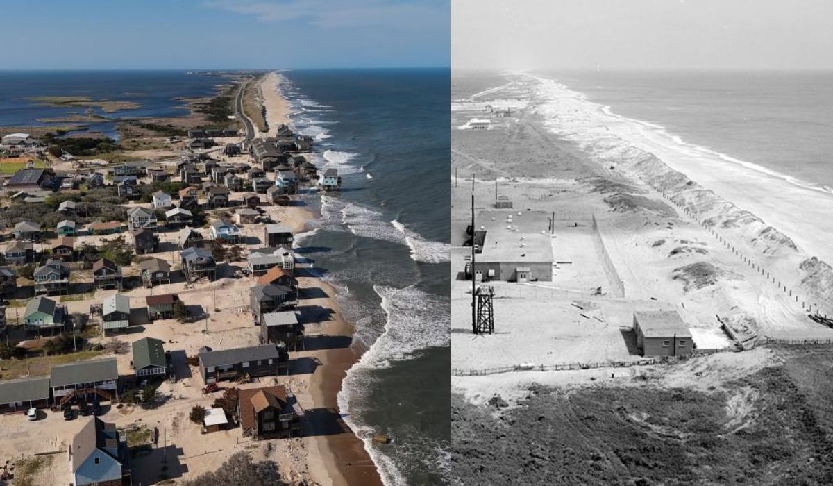
Houses moved on wheels to escape coastal erosion
Hatteras Island is part of the Outer Banks, a sequence of barrier islands formed by sand.
Unlike rocky terrains, these formations are not static.
They shift over time due to the action of winds, tides, waves, storms, and sediment circulation.
This natural behavior creates a conflict with fixed human occupation.
Houses, roads, power grids, and sanitation systems were installed over a landscape that shifts position, loses sand in some areas, and accumulates sediments in others.
According to the National Park Service, storms, waves, tides, and rising sea levels contribute to erosion in sections of the Cape Hatteras National Seashore, particularly near Rodanthe and Buxton.

In some properties, areas that previously had dry sand strips, dunes, or backyards have started to be reached by the sea more frequently.
The approach of the water alters the property’s usage conditions and increases the risk of collapse, especially when strong waves hit the stakes supporting the houses.
The situation has increased the demand for companies specialized in relocating entire constructions.
Barry Crum, a Hatteras resident who works in this type of service, told The Guardian newspaper that he had never seen the activity so busy.
The statement was made amid the increase in requests for removal and elevation of properties in the region.
Barrier island becomes narrower with sea advance
Erosion in the Outer Banks has been occurring for decades, but the recent sequence of collapses has caught the attention of local authorities and environmental agencies due to the concentration of cases in just a few months.
On September 30, 2025, five unoccupied houses fell in Buxton between 2 PM and 2:45 PM, according to the National Park Service.
A sixth house collapsed on the same day, around 11 PM.
Other incidents occurred in the following weeks.
In October 2025, new properties fell in Buxton, including five on the 28th.
Then, between February 1 and 2, 2026, four more unoccupied houses collapsed in the same community.
The most recent record from the official list consulted is from June 2, 2026, when another property fell during the early morning in Buxton.
The impacts are not limited to the owners.
When a house breaks into the sea, construction materials, parts of the structure, and household items can spread across the beach and water.
The National Park Service reports that it closes threatened areas, advises visitors to keep their distance, and coordinates cleanups to reduce risks to public safety, health, and the habitats of coastal birds and sea turtles.
For this reason, the preventive removal of properties has become one of the alternatives used in the region.
The measure does not stop erosion, but it can reduce the amount of debris in the sea and prevent entire structures from collapsing onto public-use beaches.
In communities where some houses function as vacation homes or rentals, relocation also helps preserve economic activities related to tourism.
What science explains about barrier islands
From the perspective of coastal geology, Hatteras Island is an example of the interaction between mobile natural environments and permanent infrastructure.
Barrier islands function as strips of sand between the ocean and the continent, absorbing part of the energy from waves and storms.
To sustain themselves in the long term, they depend on the circulation of sediments.
When artificial dunes, roads, houses, and containment works interfere with this flow, the behavior of the beach can be altered.
David Hallac, superintendent of the Cape Hatteras National Seashore, told The Guardian that erosion on a barrier island is not only normal but also relevant for the redistribution of sand and the reshaping of the island over time.
The NOAA, the United States oceanic and atmospheric agency, also describes barrier islands as environments vulnerable to erosion.
According to the institution, human activities, infrastructure works, dredging, and reduced sediment supply can affect these formations.
The agency also points out that the rapid rise in sea levels and extreme weather events can cause or intensify sand losses.
This combination helps explain why properties built at a distance considered safe decades ago may end up near the surf zone.
On a coast subject to continuous sediment displacement, the strip between the house and the ocean may decrease with the repetition of storms, high tides, and strong waves.
Recomposition works attempt to contain damage in Buxton
Local authorities also study and carry out interventions to contain part of the effects of erosion.
Dare County, the local government of the region, planned for 2026 a beach nourishment project in Buxton, with the placement of 2 million cubic yards of sand over approximately 95 days, depending on weather conditions.
The forecast released was for a start in mid-June 2026.
The North Carolina Department of Environmental Quality reported on February 11, 2026, that its Division of Coastal Management granted authorization for the beach replenishment project in Buxton.

The agency also stated that the reconstruction of a rocky structure near the former site of the Cape Hatteras Lighthouse was classified as a repair under state rules.
Projects of this type aim to create a wider strip of sand between buildings and the sea.
In practice, the replenishment can offer temporary protection for houses, roads, and public areas.
Coastal dynamics experts, however, note that the added sand may be redistributed by waves and storms, requiring new interventions over time.
The relocation of houses follows a similar logic: it does not eliminate the natural process of erosion but reduces the immediate risk to certain properties.
Some were moved hundreds of meters back from the shoreline; others were elevated on higher structures.
The cost, according to the original report, can reach hundreds of thousands of dollars, depending on the size of the house, the distance moved, and the complexity of the preparation.
Erosion in Hatteras exposes the challenge of other coastal areas
The situation on Hatteras Island is also observed by researchers because it brings together elements present in other low-altitude coastal regions.
Among them are occupation in vulnerable areas, sea level rise, exposure to storms, and the increasing cost of protecting fixed structures on changing terrain.
Responses vary depending on the location, the risk to the population, the environmental value, the infrastructure involved, and the financial capacity of the owners or governments.
In some stretches, authorities resort to artificial beach nourishment.
In others, containment works, road elevation, bridge construction, purchase of threatened properties, or removal of structures before collapse are evaluated.
The National Park Service reported that in 2023, it purchased two threatened properties in Rodanthe, removed the structures, and restored the beach as part of a pilot initiative to deal with at-risk properties.
The strategy differs from simple reconstruction because it removes buildings from highly exposed areas and returns space to the natural dynamics of the beach.

Another alternative discussed by experts is the planned withdrawal from vulnerable areas.
This type of measure often faces resistance because it involves heritage, rental income, tourist activity, family ties, and local identity.
Even so, on very narrow barrier islands, maintaining constructions in the same spot may require recurring expenses and not prevent further damage.
The houses transported on wheels in Hatteras show an attempt to adapt human constructions to a changing coastline.
For now, some owners choose to retreat a few meters or hundreds of meters, rather than abandon the island.