
 Portuguese
  Spanish
Phenomenon recorded in different Latin American countries transforms landscapes, pressures coastal communities, and exposes how the combination of sea, human occupation, and extreme events alters areas once considered stable.
Coastal erosion has regained relevance in public debate after international alerts released in 2024 about rising sea levels and recent episodes recorded on the Brazilian coast, such as the recognition of public calamity in Baía da Traição, Paraíba, at the end of 2024, and the completion of the beach nourishment project at Praia de Ponta Negra, in Natal, in January 2025.
The topic was also addressed on October 1, 2025, by Conexão BdF, from Rádio Brasil de Fato, in an interview with geographer Wagner Ribeiro, a professor of postgraduate studies in Environmental Science at the University of São Paulo.
Coastal erosion affects different parts of Latin America and already causes the loss of urban areas, displacement of residents, and impacts on economic activities linked to the sea.
-
Coffee Grounds Find New Purpose Beyond Waste in Innovative Uses

-
Brazilian Entrepreneur Revives Used Cookware, Now Earning $10,000 Monthly at 41

-
Bottle Caps in the Garden: A Creative Solution You Won’t See the Same Way Again
-
Brazilian Producer Adopts Hydroponic Strawberry Farming in Western Paraná, Achieving Year-Round Harvests and Becoming a Model for Continuous Production


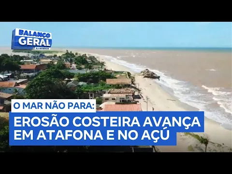
In Brazil, Atafona, a district of São João da Barra, in the north of Rio de Janeiro, is one of the cases cited by researchers and environmental agencies when the topic is the ocean’s advance over occupied areas.
The process has been recorded for decades in the district of Rio de Janeiro and has already destroyed more than 500 houses and even a building over a strip of about two kilometers, according to the report by Rádio Brasil de Fato.
The phenomenon does not occur only on the coast of Rio de Janeiro.
Sections of Chile, Argentina, Uruguay, the Caribbean, Colombia, Peru, and southern Brazil face similar processes, although with different rhythms, causes, and levels of severity.
According to experts, coastal erosion results from the interaction between the natural dynamics of beaches, rising sea levels, extreme events, and human interventions that alter sediment circulation.
Geographer Wagner Ribeiro explains that the coastline depends on the balance between sea, wind, currents, tides, and sediments.
In an interview with Conexão BdF, he stated that constructions and occupations can modify the way sand circulates and deposits on the coast.
“When we intervene in this type of dynamics, the consequences will certainly come. You can alter, for example, the tidal flow and the way sediments are deposited,” said the professor.
How coastal erosion alters the coastline
The beach is not a fixed strip of sand.
According to coastal researchers, it functions as an environment in constant transformation, shaped by the action of waves, marine currents, winds, and rivers that transport sediments to the coast.
When this cycle loses balance, the sand may no longer be replenished at the same speed it is removed by the sea.
The process can occur due to natural factors, but tends to worsen in areas with disordered occupation, removal of coastal vegetation, construction of ports, dams, retaining walls, seaside avenues, and other structures that interfere with sediment circulation.
In urbanized regions, erosion often also affects houses, hotels, streets, public equipment, and economic activities located near the beach strip.
Ribeiro highlights that one of the most relevant consequences is the entry of the sea into areas that have already been permanently occupied.
“One of the most serious is precisely the penetration of the sea into areas, sometimes consolidated with human occupation. You often have to abandon the areas, you can no longer live there because the sea is arriving with great intensity,” he stated.
Atafona and the advance of the sea on the coast of Rio de Janeiro
In Atafona, coastal erosion has been recorded for decades and is associated with factors such as the dynamics of the Paraíba do Sul River, the reduction in sediment transport, and the occupation of the coastal strip.
The district began to be mentioned in studies and reports due to the destruction of properties, streets, and urban structures affected by the advance of the sea.
According to the original text, more than 500 houses and even a building were destroyed in an area of about two kilometers in recent years.
The local population, estimated at approximately 7,000 inhabitants, has a strong connection with fishing, commerce, and tourism, activities that depend directly on the environmental and economic stability of the coastal region.
The ruins by the sea have become part of the district’s landscape and highlight, according to researchers, the difficulty of protecting occupied areas when erosion advances continuously.
For the residents, the loss of properties also involves changes in routine, displacement of families, and reduced safety in areas close to the water.
The report Rough Seas in a Warming World, released by the United Nations in 2024, points to increasing risks associated with rising sea levels.
According to the original text, areas like Atafona may lose about 150 meters of coastal strip in 28 years, a fact that reinforces the need for technical monitoring and coastal planning.
Coastal Erosion in Latin America
In Latin America, coastal erosion occurs in various contexts.
In Chile, extreme events have hit the central coast in recent years.
The original text cites waves up to 11 meters recorded in 2015 and the occurrence of about 40 extreme events per year since then, posing a risk to beaches like Reñaca and Algarrobo.
In Argentina, areas in the southeast of the Buenos Aires province were already facing critical erosion, but the problem has also been observed in other parts of the coast, according to the reference material.
Uruguay and southern Brazil appear in the same context for recording more intense storms, which can accelerate sand removal and increase damage in vulnerable coastal areas.
In Colombia, the original text reports that about half of the beaches face erosion, with sections of La Guajira losing up to four meters of coast per year.
In the Caribbean, the succession of hurricanes contributes to the wear of tourist areas, while in Peru, large ports are pointed out as factors associated with the worsening of the problem on certain beaches.
Although each country has its own characteristics, experts say that the urbanization of the coastal strip increases exposure to risks.
When houses, hotels, roads, and public facilities are built close to the shoreline, the margin for adaptation decreases and the damage tends to directly affect the population.
Fishing, Tourism, and Housing in Risk Areas
Coastal erosion is often first noticed by the reduction of the sand strip or the destruction of properties.
However, its effects also reach economic activities that depend on the stability of the coastline and the predictability of environmental conditions.
For fishermen, changes in the coastline can alter shelter areas, boarding points, boat circulation, and species presence.
Ribeiro states that the dynamics of fish schools can also be affected.
“Those who live from fishing, for example, will see that the school of fish that frequently passed by is no longer present in that area; it diverts,” he stated.
Tourism can also be impacted.
Narrower beaches, damaged structures, risks of collapse, and emergency works change the circulation of residents and visitors.
In cities that depend on the summer season, the loss of the sand strip can affect restaurants, inns, street vendors, and informal workers.
Besides the economic impact, there are social effects associated with families remaining in risk areas.
Urban planning specialists point out that populations with fewer resources often face more difficulties in leaving threatened properties, rebuilding homes, or accessing public resettlement policies.
Coastal Planning in Brazil
In Brazil, different points along the coast are experiencing advanced erosion.
In Baía da Traição, Paraíba, the federal government recognized a state of public calamity at the end of 2024 after damage associated with the sea’s advance.
The situation affected urban areas, access roads, and local communities.
In Natal, Rio Grande do Norte, Ponta Negra Beach underwent a sand strip nourishment project, completed at the beginning of 2025.
The intervention expanded the available strip in certain sections but also generated public debate about environmental impacts, maintenance of the project, and social effects for workers operating along the shore.
According to specialists, isolated solutions may have limited reach when not part of a broader coastal planning strategy.
Walls, hydraulic landfills, and other interventions can protect specific points but also need to be evaluated due to possible changes in the dynamics of neighboring areas.
Ribeiro compares the Brazilian situation with international experiences.
He cites Spain as an example of a country that was already working, back in the 2000s, with mappings related to sea level rise and coastal adaptation.
“In 2008, when I visited the city of Seville, there was already a mapping projecting sea level rise for climate change. Unfortunately, we have not reached this level of action for Brazilian territory,” he said.
Monitoring Coastal Erosion and Public Policies
Despite the absence of an integrated national planning mentioned by the professor, technical initiatives aim to monitor the evolution of the problem in different regions.
In Rio Grande do Sul, ProCostaRS, led by the Federal University of Rio Grande do Sul, was created with the goal of monitoring coastal erosion and anticipating risk scenarios.
The system intends to gather data on oceanographic, meteorological, and environmental events, in addition to supporting analyses on coastal vulnerability.
The proposal is to offer technical information to guide public managers in formulating prevention policies, adaptation works, and protection measures for exposed communities.

Continuous monitoring is considered important by researchers because erosion does not occur in the same way along all sections of the coastline.
In some areas, sand loss is slow and progressive.
In others, storms, surges, and human interventions can accelerate changes in shorter intervals.
The dynamics between land and sea have always been part of the formation of beaches.
The difference, according to specialists, lies in the increased exposure of urbanized areas and the need to plan the use of the coast based on technical data.


