Portuguese
  Spanish
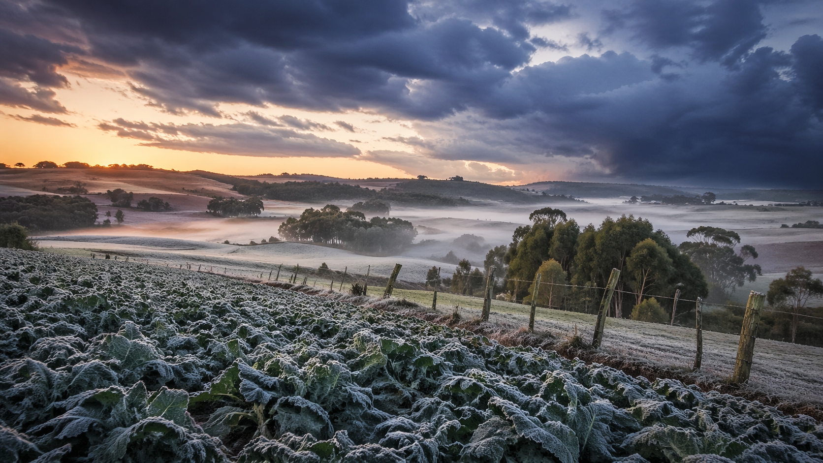
Temperature drop marks the start of cold weather in the South as climatic extremes intensify in Brazil, with direct impact on agriculture and heightened attention for the coming days
Brazil officially began its cold season in 2026 with the first frost recorded in the South of the country, a phenomenon that, although expected during this transition period between autumn and winter, was surprising due to the intensity of the temperatures. At the same time, the climatic scenario becomes even more concerning with the arrival of intense storms and accumulated rainfall that could exceed 120 mm in some regions.
Immediately after the extended holiday, rural producers and specialists turned their attention to the weather’s behavior. Although agribusiness did not suffer direct impacts from this first frost, the event serves as an important warning for the coming weeks. The information was released by “Notícias Agrícolas”, based on detailed meteorological analyses and real-time monitoring of atmospheric conditions in the country.
Cold air mass drops temperatures below 5°C and favors frost formation
In recent days, a cold air mass advanced strongly over Southern Brazil, causing significant temperature drops, especially in Rio Grande do Sul, Santa Catarina, and southern Paraná. In mountainous regions like São Joaquim, Urubici, and Lages, thermometers registered below 5°C, an ideal condition for light frost formation.
-
Brazil Unveils Innovative Monitoring System to Prevent Abandonment of Public Works, Boosting Efficiency and Reducing Waste in Infrastructure Projects

-
AI Video Generator Automatically Creates Subtitles and Animated Captions

-
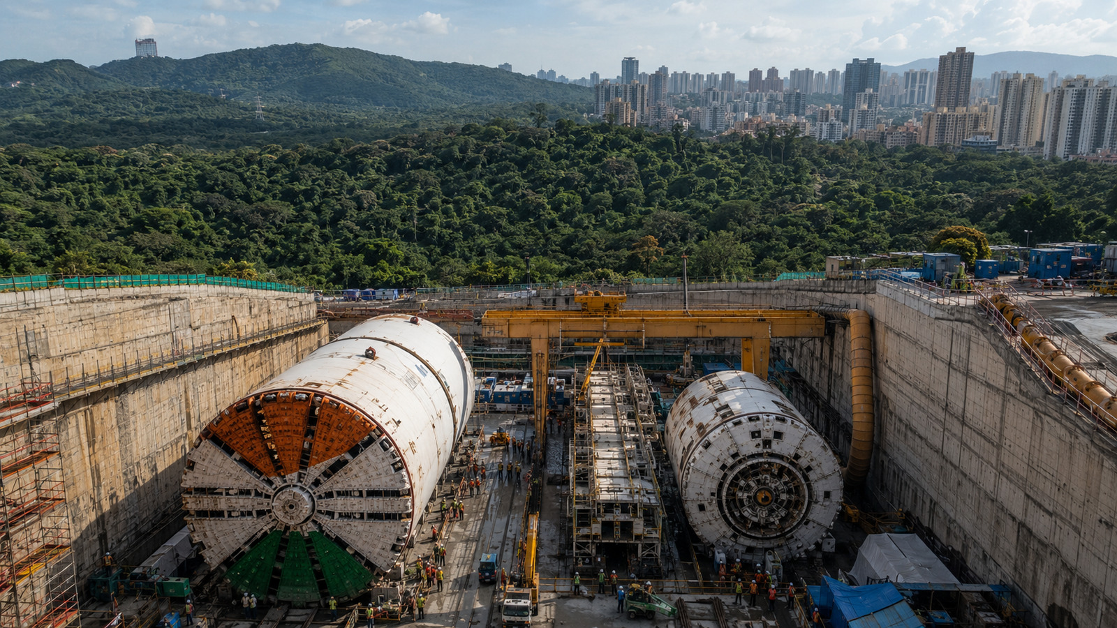
São Paulo Unveils Latin America’s Largest Underground Reservoir, Holding 900 Million Liters, in the Greater São Paulo Area

-
Chinese Teen Wins Gold in Germany for Invention Turning Air Moisture into Underground Irrigation in Drought-Stricken Areas


Despite the record, specialists emphasize that there was no significant damage to agribusiness. Nevertheless, the phenomenon draws attention, mainly because it occurred at the beginning of the season, indicating that more intense episodes may emerge in the coming weeks.
Furthermore, the cold weather is also expected to boost tourism in the mountainous regions, traditionally sought after during periods of lower temperatures. However, the scenario will not be static. This is because a new cold air mass is forecast to advance starting Sunday, bringing further temperature drops, but mainly restricted to the Southern region.
On the other hand, areas of the Southeast and Central-West should remain under the influence of a hot and dry air mass, with above-average temperatures, potentially staying between 3°C and 6°C higher than normal for the period.

Storms advance and accumulated rainfall could exceed 120 mm in Rio Grande do Sul
While the cold makes its presence felt in the South, another phenomenon stands out: the advance of strong instabilities. The forecast indicates heavy rains between Thursday and Friday, mainly in Rio Grande do Sul, with significant volumes.
In cities like Júlio de Castilhos, accumulations can reach 93 mm, while Sobradinho is expected to exceed 100 mm. However, the biggest alert is for areas between São Tiago and Tupanciretã, where volumes may surpass 120 mm by the end of Sunday.
Additionally, regions like Porto Alegre, Caxias do Sul, Lajeado, and Canela are also expected to face severe weather conditions, with a risk of storms and intense showers.
As the days progress, these instabilities are expected to reach Santa Catarina and Paraná, although with less intensity. In western Paraná, for example, accumulations can vary between 25 mm and 43 mm, while in Santa Catarina, there is a forecast of up to 35 mm in various locations.
Center of the country faces heat, low humidity, and increasing climate risk
While the South deals with cold and heavy rains, the scenario is completely different in the rest of the country. Regions in the Southeast and Midwest are experiencing a dry period, with low relative humidity and virtually no rainfall.
In cities like Uberlândia, humidity can drop to 34%, while in Passos, in southern Minas Gerais, the indices are expected to be around 36%. This pattern reinforces the typical autumn trend, with a gradual reduction in humidity that is expected to intensify until winter.
Furthermore, the lack of precipitation — with volumes close to 0 mm in several areas — raises alerts for impacts on soil, agriculture, and the risk of wildfires.
North and Northeast remain on alert with heavy rains and high accumulations
In contrast, the North and part of the Northeast continue under the influence of the Intertropical Convergence Zone, which maintains high volumes of rain in the region.
In Belém, for example, accumulations can reach 60 mm by Sunday, while cities like Bragança record up to 80 mm. Between Acará and Tomé-Açu, volumes may exceed 100 mm.
Other regions are also concerning. In Boa Vista, accumulations can reach 87 mm, with isolated points reaching 123 mm. In Manaus, the forecast is 71 mm, while Santarém may register up to 80 mm.
In the Northeast, cities like Salvador are expected to accumulate up to 65 mm, while Natal and João Pessoa may exceed 50 mm. Still, in the interior, the rains tend to be quicker and with low volumes, often not exceeding 10 mm.
In light of this scenario, experts emphasize the importance of constant monitoring of weather conditions, as Brazil faces a pattern of simultaneous extremes: cold in the South, heat and drought in the Center, and heavy rains in the North and Northeast.