
 Portuguese
  Spanish
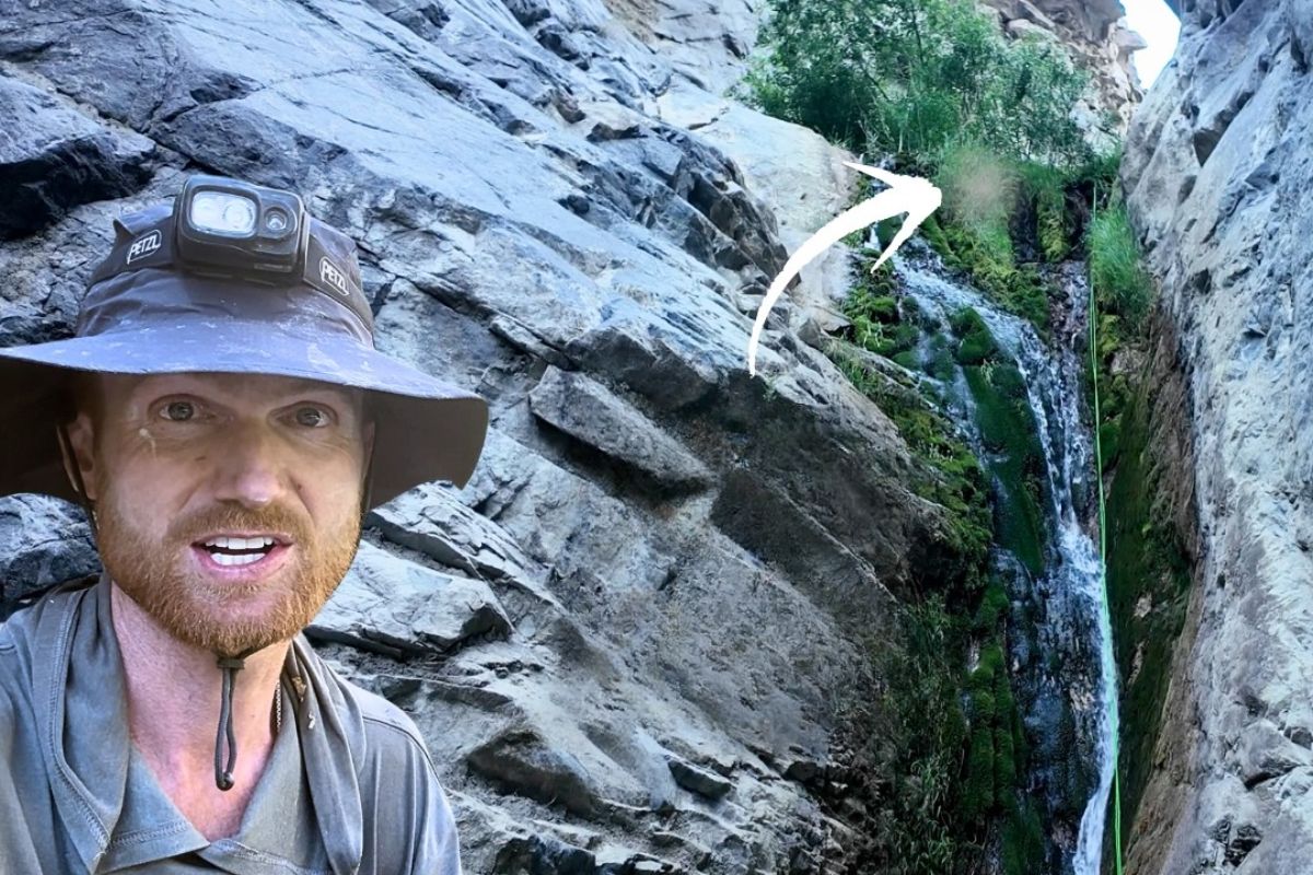
The Crossing That Traverses the Inyo Mountains to McElvoy Canyon Is Not a Common Adventure Route. Instead of Safety Cords, Signs, or Official Trails, There Are Slopes of Loose Schist, Slopes That Seem Like Walls, and a Valley Described in the 19th Century as “So Vertical That Nothing Without Wings Could Access It.”
It is in this setting that a modern hiker decides to retrace, step by step, the path of Marion Howard, the beekeeper who swapped conventional life for years in abandoned mines, makeshift cabins, and ladders hanging over waterfalls, in an extreme and high-risk environment.
Over more than 35 hours of accumulated movement, with about 2,400 meters of ascent and 2,700 meters of descent, the crossing becomes more than just a physical challenge; it functions as a real-time investigation. Every repurposed tunnel, every forgotten wood stove on the slope, and every piece of beekeeping equipment still in place help to reconstruct the decision of a man who spent years almost alone in a little-visited canyon, surrounded by snow, desert, and silence, in conditions that today would be considered quite dangerous.
An Almost Inaccessible Canyon and an Out-of-Place Beekeeper
The starting point of the crossing is the Inyo Mountain Range in California, the lesser-known counterpart of the Sierra Nevada, separated by a valley where Lone Pine and other small communities are located.
-
Survivor of 1966 SS Daniel J. Morrell Shipwreck in Lake Huron Recounts 38-Hour Ordeal in Extreme Cold

-
The Greatest Hoax in World Cup History? The Film That Denied Brazil’s 1958 Victory and Exposed How Fake Evidence Can Seem Convincing on TV
-
Fake South Korean Online Stores Offer Shopping Thrill Without Spending Money or Receiving Products
-
The War of Jenkins’ Ear: How a Severed Ear Sparked One of the 18th Century’s Most Unusual Conflicts


On one side, the snowy slopes of Mount Whitney and the Pacific Crest Trail; on the other, a set of dry, inclined, and fragile cliffs, marked by old mining fronts and slopes that give way at the slightest misstep. It is on this less frequented side of the map that McElvoy Canyon lies hidden, historically associated with gold mines and described in 19th-century newspapers as inaccessible “to anything without wings.”
It was in this environment that Marion Howard chose to live for nearly two decades. Born in Pennsylvania, having served in World War II and with a history of moving to the American West, he eventually adopted the Inyo as his permanent destination.
Rather than seeking a fertile valley, a ranch, or a small town, Howard brought beehives to one of the steepest, driest, and most difficult-to-access places in the continental United States. The current crossing attempts to understand to what extent this choice was a quest for tranquility, a conscious distancing from urban life, or merely the result of a sequence of personal choices in a remote territory.
The Route of the Crossing to the Hidden Cabins
The route followed by the modern hiker combines accounts from mountaineers, old mining maps, and terrain observations from satellite images. The aim is to reconstruct, as faithfully as possible, the path used by Howard between the valley and his cabins.
In practice, this means starting on a 19th-century mining trail, losing the trace of any marked path before reaching 3,000 meters in altitude, and continuing in a line of maximum difficulty, ascending loose schist slopes where each step sinks and the body slides back a few centimeters.
Right from the first five hours of ascent, the crossing encounters one of the cabins repurposed by Howard: a wooden structure erected by old miners, embedded in the slope, with a wood stove, remnants of newspapers from the 1970s, and signs of prolonged occupancy. These intermediate shelters functioned as stopping points during stormy days or on long moves with heavy loads of equipment and supplies.
The landscape viewed from the door of these cabins is always the same combination of chasms, snow-capped peaks, and red canyons, reinforcing the sense of distance from any form of public service, quick rescue support, or vehicle access.
Mine Tunnels, Stoves, and Daily Life in a Remote Area
At the top of the crossing, the route passes through mine tunnels used directly as housing. In one of them, about 20 hours of accumulated walking since the start of the journey, Marion Howard’s boots, worn clothes, a canvas bag for carrying loads, old honeycombs, a beekeeper’s smoker, and a carefully installed cast iron stove are still there. Everything indicates a routine of permanence, not just passage.
Howard lived for years in one of those tunnels, taking advantage of the natural shelter against snow, wind, and abrupt temperature changes, in addition to the proximity of water that flowed through the rocks.
Reports from those who interviewed him in the 1980s indicate that he himself recognized that the area was not a good place for bees, due to the constant presence of wax moths in warm weather. Nonetheless, he maintained his beekeeping project, losing entire colonies over time.
This reveals that the strictly economic logic of the activity does not explain the permanence. The choice of location came first, and beekeeping seems to have been the means available to sustain a very specific lifestyle in a poorly protected geography.
Descending to McElvoy: When the Crossing Changes Format
After crossing the ridge that separates Owens Valley from Saline Valley, the crossing changes character. If the ascent is marked by vertical gain on unstable slopes, the descent is a sequence of routing decisions with minimal margin for error.
The path to the bed of McElvoy Canyon involves losing nearly a thousand meters of altitude over less than two kilometers, on steep rocky terrain, mirrored by the equally vertical walls on the other side of the valley.
From that point on, the challenge is no longer just choosing the least risky ramp but managing what makes McElvoy one of the most dangerous canyons in the region: dozens of waterfalls squeezed into a narrow corridor, surrounded by wild rose bushes with thorns above waist height.
There are sections where progress is literally measured in meters per hour, with the explorer cutting branches with a machete, grabbing onto roots, improvising natural anchors, and descending wet walls with ropes, while the underbrush tears at equipment, knocks down cameras, and drenches clothes and sleeping bags. The crossing makes it clear that any attempt to navigate this route without proper preparation, planning, and support represents a tangible risk to physical integrity.
Discreet Ladders, Successive Waterfalls, and Access Engineering
Old records indicate that Marion Howard built rope and wood ladders at various waterfalls in McElvoy Canyon, especially those closest to Saline Valley. These structures allowed him to ascend and descend sections that would be practically impassable without support.
During the current crossing, the hiker still finds traces of this human interference in one of the water fall sections, confirming that the beekeeper not only passed through there but also systematized access for repeated use.
In other areas, however, the succession of waterfalls is so long and so linked that it raises the question of whether Howard truly completed the route all the way to the interior of the canyon by this water line. In just one segment, there are more than nine drops with enough height to require rappelling.
The absence of ladder marks on some of them fuels the hypothesis that the beekeeper concentrated his efforts in the lower part, leaving more internal sections without a defined route, which reinforces the labyrinthine character of the region and the difficulty of reconstructing each movement made decades ago.
Physical Overcoming, Mental Wear, and the Limit of the Body in a Hostile Environment
In the final tally, the crossing adds up to about 35 hours of effective movement, distributed over journeys of up to 15 consecutive hours on technical terrain, with a heavy backpack, 90 meters of rope, four cameras, safety gear, and limited food.
Along the way, the hiker reports progressive exhaustion, disillusionment in more closed brush sections, frustration with lost equipment, and the realization that, at many moments, the priority shifted from documenting the experience to simply getting out of the canyon safely and in good physical condition.
This mental component is central to understanding what differentiates this crossing from a classic high mountain walk. Instead of well-defined peaks, there are successive points where retreat becomes as laborious as moving forward.
Rather than predictable refuges or shelters, what exists are makeshift cabins, cold tunnels, and narrow clearings where one sleeps in the open, exposed to the wind and the possibility of new cold fronts. The journey reinforces that such remote environments are not a neutral backdrop for adventure, but unstable systems where any simple error can have serious consequences.
What the Crossing Reveals About Radical Life Choices
By reconstructing Marion Howard’s path through the Inyo Mountains and McElvoy Canyon, the extreme crossing ultimately offers a broader reading of these choices. Anyone making such a decision is someone willing to reorganize their entire routine around a remote place, with little external support and high exposure to environmental risks.
How long this lasts depends on practical factors, such as age, health, income, access to supplies, and ability to handle emergencies. The gesture itself, however, is clear: exchanging a fixed address, streets, and services for slopes of schist, old mining trails, and successive waterfalls.
The exact reason is never fully articulated. Interviews recorded years later suggest discomfort with war, fatigue from large cities, and affinity with certain religious groups, but none of this alone explains the choice of a canyon described as “inaccessible to anything without wings.”
What the crossing shows, primarily, is that Howard built an environment coherent with his decision: discreet trails, stone cabins, adapted tunnels, beehives in an unfavorable setting but sufficient to maintain an autonomous and extremely demanding way of life. At the same time, the very difficulty of the current route serves as a warning about the real cost of such radical choices, both for the body and the mind.
How Far Would You Go on a Crossing Before Missing the Connected World?
At the end of the route, there are fewer answers than sensations: the dense silence of a mine tunnel still full of boots, books, and honeycombs, the sight of a clear stream running at the bottom of a surprisingly closed canyon, the physical marks of a crossing that put body and mind to the test to follow the steps of someone who lived for years in one of the most difficult places to reach in California.
In light of this story, the discussion shifts from solely revolving around Marion Howard to addressing the reader: in a scenario where most people live surrounded by screens, notifications, and commitments, to what extent would a crossing in a remote environment make sense to you before you began to miss the safety, companionship, and structure of connected life, and why?


-

-

-

-

-

-

81 people reacted to this.