Portuguese
  Spanish
New feature started appearing for some users and adds traffic lights to the Waze map, with a direct impact on the reading of intersections, speed reductions, and turns on urban routes still in gradual distribution.
Waze has started to release the display of traffic lights on the map for some users, in a change that expands the visual information available during navigation and meets a recurring request from drivers.
The new feature appears gradually, not necessarily depending on a manual update of the app, and has not yet been made available to all accounts.
According to 9to5Google, the feature underwent testing over the past few months and was initially seen in December 2025.
-
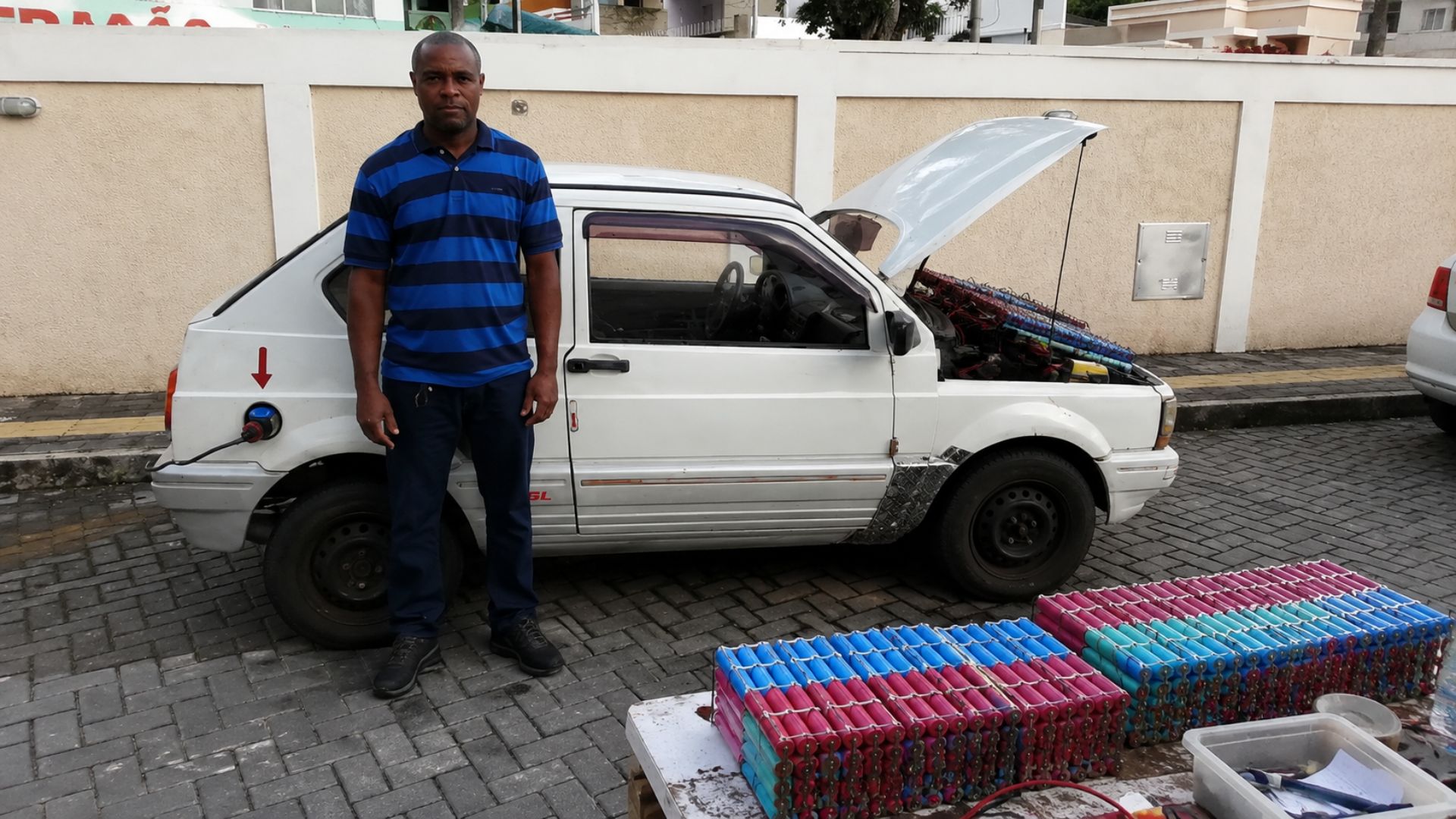
Brazilian Innovator Converts Old Car into Electric Vehicle Using Laptop Batteries and Forklift Motor, Achieves Nearly 90 km/h in Urban Settings

-
Samsung Unveils Smart Oven with Built-In Camera, AI Food Recognition, and Real-Time Monitoring via Smartphone.
-
Ocean Transformed into Sci-Fi Lab: 87-Meter Structure with Submarines, Deep-Sea Robots, Helicopter, Genetic Labs, and 8K Cameras Unveils Rare Creatures
-
11-Year-Old Develops Solar Water Purifier to Aid Communities in Kenya and Gambia


In June 2026, user reports indicated a wider, although still irregular, distribution, with icons appearing both during active routes and in the common map view.
With the change, the app now shows in advance intersections regulated by light signals, information that can assist the driver in reading the route before approaching the stopping point.
In practice, the visualization allows identifying where there is a speed reduction or mandatory stop, especially on unfamiliar routes, long avenues, and roads where the traffic light only becomes evident when the vehicle is already close.
Waze is known for using real-time alerts sent by drivers, such as traffic jams, accidents, roadworks, road hazards, and route changes.
The platform itself describes the service as a navigation app with real-time traffic alerts provided by other drivers.
Traffic lights on Waze arrive gradually
The release of traffic lights is not yet occurring uniformly among users.
While some accounts already display the icons on the map, others still do not have access even with recent versions of the app installed on the phone, indicating a gradual activation controlled by the platform.
Distributions of this type can occur on the server side, when the company enables the feature by account, region, or user group.
For this reason, downloading Waze again or looking for an update in the app store does not guarantee that the feature will appear immediately.
The most recent initial reports cited by 9to5Google involve users in the United States.
Even in these cases, the presence of the icons does not mean that all traffic lights in the same city are already registered, because coverage may vary depending on the area analyzed and the availability of data.
The function also brings Waze closer to features already available in competing apps.
Google Maps and Apple Maps have been offering this type of visual reference for a longer time, while Waze focused its experience mainly on collaborative alerts and dynamic traffic information.
What changes in navigation for drivers
The display of traffic lights adds a permanent visual reference to the map during navigation.
By identifying a signal before reaching the intersection, the driver has more time to adjust speed, choose the correct lane, and prepare for a turn without relying solely on the physical signage of the road.
This type of information can be useful in places where visibility is impaired by curves, trees, larger vehicles, or busy intersections.
On long avenues, the presence of the icon can also help the driver recognize stopping points before physically seeing the traffic light.
Even so, the feature does not replace attention to traffic nor does it alter the driver’s responsibility.
The map serves as a navigation aid, but road signs, pedestrians, other vehicles, and real road conditions remain the main references during driving.
So far, there is no reliable indication that Waze is showing the real-time status of traffic lights, such as green, yellow, or red lights.
Based on the available information, the icons indicate the presence of the equipment on the route, not the exact operating cycle at each intersection.
Traffic light coverage still varies by region
The incomplete distribution explains why some drivers see few traffic lights, even in urban areas with many signaled intersections.
As the function is still expanding, the absence of an icon on the map does not necessarily mean that there is no light signal at that point.
Another point observed in the available reports is the lack of a broad option for the user to inform the presence of a normally functioning traffic light.
In the app, there is the possibility to report faulty traffic lights, but there is no indication that all users can freely register existing signals on the roads.
This limitation helps explain the irregularity of coverage in some areas.
If the database depends on internal steps, prior mapping, or community validation, the display tends to advance at different rates between countries, cities, and road corridors.
Waze has also not yet released a public schedule for making the traffic lights available to all users.
As a result, the arrival of the feature may occur without visible notice and without a perceptible change in the installed version of the app.
Waze adds permanent visual reference to the map
The arrival of traffic lights increases the number of fixed elements displayed by Waze, an app historically associated with driver collaboration and rapid traffic condition updates.
The change maintains the focus on community alerts but adds a layer of permanent guidance to the map.
In complex urban routes, the difference tends to appear mainly in the early reading of intersections.
In addition to voice instructions and upcoming turns, the driver now has an additional visual signal to interpret the path before reaching the decision point.
The feature, however, is still in the phase of gradual implementation.
Until the release is completed and the traffic light database is more consistent, the experience may vary between users, cities, and even different sections of the same route.