Portuguese
  Spanish



Study from the University of Utah identified freshwater in deep sediments beneath the Great Salt Lake and opened a new research front
Researchers from the University of Utah discovered a freshwater reservoir beneath the Great Salt Lake in Utah, in the United States, stored in sediments saturated up to 4 kilometers deep, a discovery that could change the water understanding of the region.
Mapping of freshwater
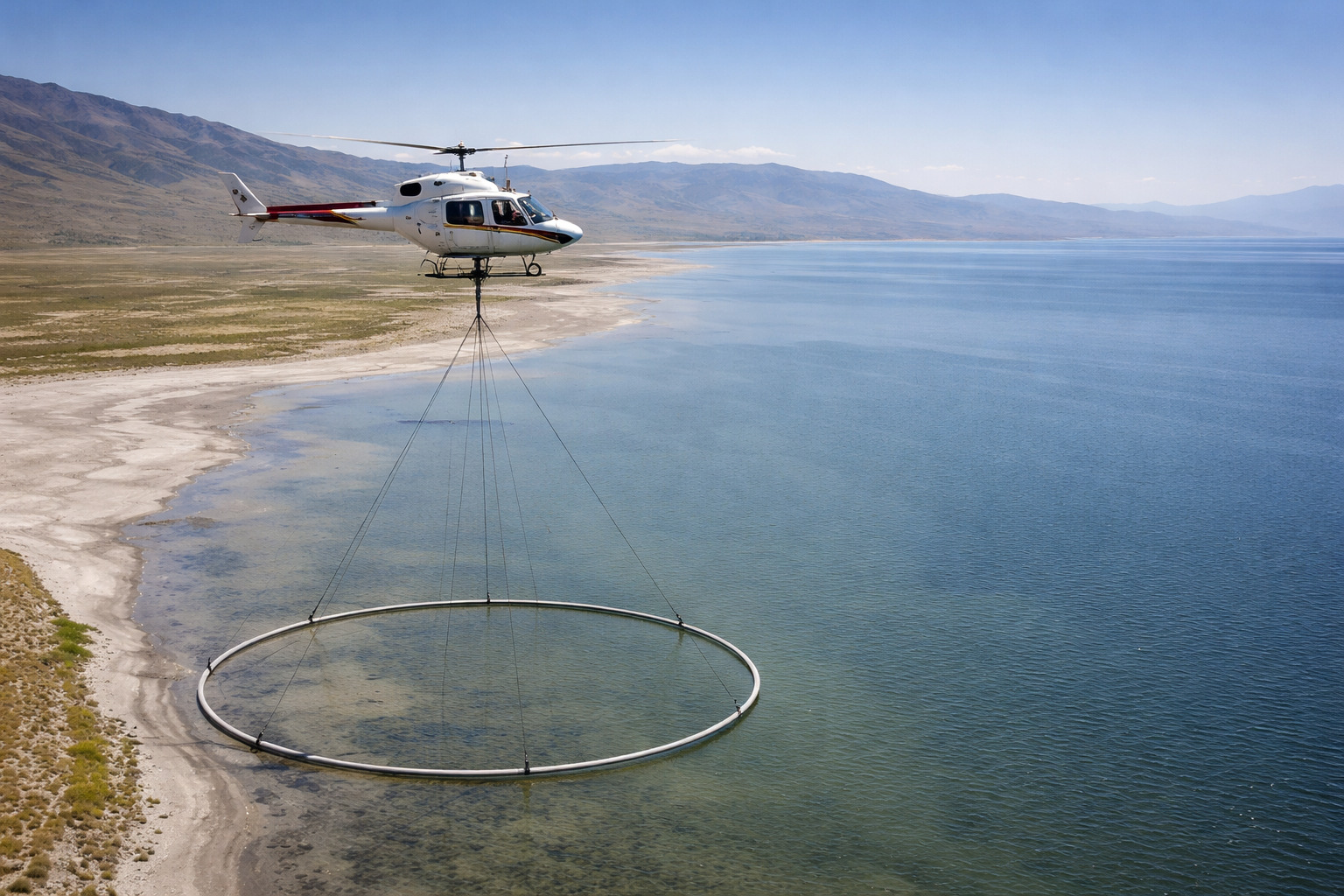
The team used a helicopter with sensors to conduct an aerial electromagnetic survey, the AEM, over Farmington Bay, on the southeast edge of the lake.
The technique measures electrical conductivity, which helps differentiate saltwater from freshwater and examine the composition of rocks.
-
She spent 73 years breathing inside an iron lung, survived the aftereffects of polio, and became the last woman in the United States dependent on the equipment before dying at 78 years old.

-
Brazilian students created a $1 filter using pine bark, cotton, and 3D-printed parts to clean cassava wastewater, reduce the toxicity of a hazardous waste, and transform contaminated water into biofertilizer.

-
Astronaut from Artemis II steps down after mission to the Moon and decision surprises after a record of 406,771 km, a historic 10-day journey, and an unprecedented achievement for Canada.

-
A fossil kept for years in a small museum in Montreal concealed 450-million-year-old soft tissue, a discovery that has only happened once before in history.


Michael Zhdanov said that the work allowed them to answer how deep this potential reservoir is and what its spatial extent is beneath the eastern margin of the lake.
According to him, by knowing depth, width, and porous space, it is possible to calculate the potential volume of stored freshwater.


The depression beneath the lake
The survey revealed a sudden drop in the bedrock depth beneath the Great Salt Lake. This depression created a space filled with sand and sediments saturated with freshwater.
Researchers estimate that the reservoir could extend between 3 and 4 kilometers deep. So far, however, only a small area of the lake has been scanned.
There had already been suspicions about freshwater beneath the Great Salt Lake, partly due to the vegetation-covered islands that have appeared throughout the basin.
Even so, this was the first time scientists attempted to seriously assess the actual size of the reservoir.
What surprised the team
The presence of freshwater was not the main surprise. What caught attention was the potential coverage area revealed by the data.
The reservoir also showed that the rocky basin containing the sediments extends further into the center of the Farmington Bay plain than expected.
Johnson told the Cool Science Radio program that the unexpected part was not the salt lens seen near the surface in the plain.
According to him, the surprising point is that the freshwater beneath this layer extends into the lake and possibly beneath the entire lake.
Some freshwater along the shores was expected, as it flows down from the surrounding mountains. Still, the data indicate more freshwater across the 2,500 square kilometers.
Possible use against dust
The researchers believe that this water may have important utility. With the continuous evaporation of the waters of the Great Salt Lake, the remaining dust has become a health problem for neighboring communities.
This dust is carried by the wind to urban areas of Utah, carrying toxic metals. Wetting these areas with freshwater may help reduce this problem.
Bill Johnson stated that there are beneficial effects of this groundwater that need to be understood before extracting more of it.
According to the hydrologist, a top priority is to know if it would be possible to use this freshwater to wet critical dust points and significantly reduce them without disturbing the system.
Expansion of research
The team is working to obtain funding and expand the scope of the AEM survey, analyzing more areas of the lake.
The focus will be to map the limits of the sudden drop in the bedrock. This could better indicate how much freshwater is stored on-site and help in water resource planning.
Similar techniques could also be applied in other locations, combining magnetic readings to estimate rock depths and electrical conductivity readings to estimate freshwater areas.
The discovery was published in the journal Scientific Reports and may represent a water resource in a region facing increasing challenges of water scarcity and environmental pollution.
With information from Olhar Digital.