Portuguese
  Spanish


Coastal erosion devours Atafona, district of São João da Barra, in the North of Rio de Janeiro, for over 60 years, and now an engineering study with federal funding attempts to halt the advance of the sea over the shore, at the mouth of the Paraíba do Sul river, before the district disappears from the map for good.
On the northern coast of Rio de Janeiro, the district of Atafona, in São João da Barra, offers one of the harshest images of coastal erosion in Brazil: houses split in half, streets that simply end in the water, and concrete debris scattered across the sand where entire blocks once stood. According to a report by iG Último Segundo published in July, the São João da Barra City Hall estimates that around 500 houses, businesses, and buildings have already been swallowed by the advancing sea over decades, in a process that has turned more than 2,000 residents into environmental refugees since the 1960s. With approximately 6,000 inhabitants and located right at the mouth of the Paraíba do Sul river, the district has become the national portrait of what coastal erosion is capable of doing.
The novelty that changes the course of this story did not come from the sea, but from the engineering table. According to J3News, the company responsible for preparing the technical, economic, and environmental feasibility study, the EVTEA, has been defined, which will indicate how to contain coastal erosion in Atafona and the neighboring district of Açu. Mayor Carla Caputi confirmed the progress, and the federal government conditioned the release of containment funds on the delivery of this study. After decades of losses and a demand from the Federal Public Ministry that has dragged on since 2008, for the first time there is a concrete coastal protection plan being drawn up for the district.
Atafona, the district that the sea is slowly swallowing
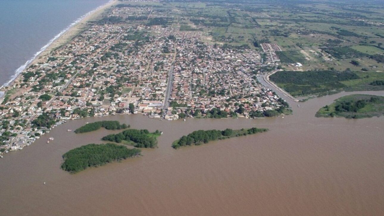
Panorama of the Paraíba do Sul river, which also advances over Atafona
Those visiting Atafona for the first time find it hard to believe that the scene of ruins was once a bustling seaside resort. The sea has already demolished 14 entire blocks, erased more than 60 streets from the map, and left behind a field of debris that residents call a ghost town. Crooked poles, cracked walls of houses, and ceramic floors floating in the tide make up the landscape of a place that loses ground to the water year after year.
-
From Advertising Student to Havaianas Partner: João Boto Turns Açaí, Jambu, and Amazon River Dolphins into Sportswear with $200 Startup

-
São Paulo to Host Brazil’s Largest Military Aviation Museum, Aiming for Global Top Five by 2027 with 100 Aircraft Displayed
-
Entrepreneur Leaves Job After 20 Years, Invests Under $200 to Launch Sustainable Craft Store Inspired by Beeswax Wraps, Now Earning $7,000 Monthly

-
Long Island Home Found with Over 155 Animals, Including Sick Cats and Dogs Without Clean Water, Amid Strong Ammonia Odor Leading to Police Investigation


The human toll is even heavier than the physical toll. The more than 2,000 people who have had to abandon their homes since the 1960s are now treated as environmental refugees within their own country, people who saw their family property disappear under the sand and foam. Many rebuilt their lives further inland, always with the fear that coastal erosion might reach them again. The estimate of about 500 destroyed properties, made by the City Hall of São João da Barra, includes vacation homes, permanent residences, and commercial points that sustained the local economy.
The most frightening thing is that the sea has not relented. What was a sporadic problem in the 1960s has turned into continuous coastal erosion, which swallows the strip of sand, advances over the next street, and when it reaches the buildings, it usually leaves nothing standing.
Why is coastal erosion advancing so quickly in Atafona?
The easiest answer would be to blame only the climate, but the technical explanation is much more interesting and starts upstream. The main driver of coastal erosion in Atafona is the loss of strength of the Paraíba do Sul River, which over the past decades has seen its flow plummet due to flow diversions, extractions, and dams along its course. A strong river carries sediments, that is, sand and fine material that deposit at the mouth and replenish the beach. A weakened river carries much less.
Without this constant reinforcement of sediments coming from the Paraíba do Sul River, the coastline stops rebuilding at the same speed that the sea erodes it. It’s like a bank account that only has withdrawals and almost no deposits: the sand balance plummets. This imbalance is compounded by the convergence of wave energy in that stretch of coastline, which hits with concentrated force precisely on the Atafona shore and accelerates the sea’s advance over what remains.
That’s why experts insist that the case is not a simple story of high tide. It’s an engineering and hydrology problem, where the reduction of sediments from the Paraíba do Sul River and the shape of the coast together explain why the erosion of the shore there is so fast and so difficult to stop without a coastal protection project.
A sea advance of up to 8 meters in a single year
Putting numbers on the problem helps to understand its magnitude. On average, the sea advances about 3 meters per year over Atafona, but this average hides frightening peaks. In certain years, the sea’s advance exceeded 5 meters, and there are records of seasons when the coastline receded nearly 8 meters at once. For those living just a few meters from the water, this means going to sleep with the beach in one place and waking up with it much closer to the door.
This pace is not new, but it has accelerated over the last 60 years, precisely following the weakening of the Paraíba do Sul River. Each lost meter does not return: the sand disappears, the foundation is exposed, and the next storm surge usually finishes the job. This is how entire streets, one after the other, disappeared under the tide.
An important caveat to avoid exaggerating the data: the 5 meters per year cited as a reference is a peak, not a constant average. Even so, the average of 3 meters per year is brutal when summed over six decades, and it explains why coastal erosion has already reorganized the entire geography of the district.
Company Selected to Study How to Contain Coastal Erosion
After years when the public response seemed to always stall, the turning point came with the hiring of a specialized company. The mayor of São João da Barra, Carla Caputi, announced that the company responsible for preparing the EVTEA, an acronym for technical, economic, and environmental feasibility study, has already been selected. This study will precisely determine which coastal protection work is viable for Atafona and the district of Açu. The study is entrusted to the company Caruso Jr., recognized for its experience in coastal works.
The detail that unlocks everything is financial. The federal government conditioned the release of funds for coastal erosion containment on the delivery of this study, meaning without the EVTEA, the money won’t be released, and without money, the work won’t proceed. Therefore, the selection of the company is not bureaucracy: it is the first real step towards coastal protection that Atafona has awaited for generations.
The pressure to reach this point is longstanding. The Federal Public Ministry has been demanding a solution to the problem in Atafona since 2008, and for a long time, the feeling was that the district would be left to its own fate. The commissioning of the study changes this game because it transforms the vague promise of aid into a technical stage with a deadline, responsibility, and clear destination.
Which Works Can Contain the Sea’s Advance in Atafona?
This is the question that the EVTEA will answer, but the technical alternatives are already on the table, and it’s worth knowing each one. Beach nourishment, also known as beach widening, involves depositing large volumes of sand brought from elsewhere to rebuild the lost strip, restoring the natural barrier to the shoreline that coastal erosion has taken. It is one of the most used solutions worldwide to hold the coastline.
There are also fixed structures. A groyne is a kind of stone or concrete arm that extends into the sea, perpendicular to the beach, to hold the sand that the current would carry away. Riprap is a wall of stacked rock blocks along the coastline, acting as a shield against the waves. There are also more modern solutions, such as the bagwall, big bag, and betonbloc, which use large bags and filled blocks to form barriers that are quicker to install.
Each technique has different costs, durability, and side effects, and this is exactly what the study needs to calculate in São João da Barra. A poorly positioned groyne, for example, can hold sand at one point and accelerate coastal erosion at a neighboring one. Therefore, no one will simply choose at random: the decision on which work will stop the sea in Atafona depends on the technical diagnosis that the contracted company is tasked with delivering.
What the UN Says About Atafona and Rio de Janeiro
The drama of Atafona has also entered the international radar. The report Surging Seas in a Warming World by the United Nations placed the district and the city of Rio de Janeiro among the 31 most vulnerable locations in the world to rising sea levels. This is not just any label: it means that the local problem has gained global dimension and served as a warning about the seriousness of what is happening on the coast of São João da Barra and the state.
The numbers help to understand the concern. According to the survey, the sea level has already risen about 13 centimeters in the region over the last 30 years and could rise another 16 centimeters by 2050. It seems little, but on a coast that is already suffering from this accelerated erosion, each additional centimeter of sea pushes the coastline further inland and increases the pressure of the sea on buildings.
It is important to separate things to not distort the UN’s message. The report points out vulnerability and projects the rise of sea level, but does not state that entire buildings have already sunk. The destruction already occurred in Atafona is mainly the result of coastal erosion linked to the loss of sediments from the Paraíba do Sul river, while the rise of sea level acts as a factor that tends to worsen the situation in the future. Combined, the two help to explain why coastal protection in the district has become urgent.
What coastal erosion has to do with Brazil
Atafona is the most extreme case, but it is far from the only one. A large part of Brazilian beaches already live with some degree of coastal erosion, from the Northeast to the South, whether due to the natural action of the waves, the disordered occupation of the coastline, or the reduction of sediments reaching the coast, as happens at the mouth of the Paraíba do Sul river. The advance of the sea over houses, avenues, and kiosks is a real concern in various parts of the country, even if none come close to the devastation seen in the North Fluminense.
Brazil also already has examples of successful coastal protection. In Itapoá, Santa Catarina, a large beach nourishment returned sand to the coastline and recovered the strip that the sea had taken, showing that there is an engineering solution when there is a project and funding. These are experiences that serve as a reference for what Atafona is now trying to structure.
What makes Atafona a national symbol is the limit the district has reached. It was necessary to lose about 500 properties, dozens of streets, and entire blocks for coastal erosion there to force a serious engineering study and the promise of federal funding. If the response works in São João da Barra, the model of confronting the sea may inspire other Brazilian cities that see the coastline shrinking and still do not know how to react.
Could Atafona disappear before 2100?
It is the question that haunts the residents, and the projections are not encouraging. Simulations by the Fluminense Federal University, UFF, indicate that if the current pace is maintained, more than a thousand constructions could be lost by 2100, which in practice means the disappearance of the district of São João da Barra as it is known today. In other words, without intervention, Atafona runs the real risk of vanishing from the map before the end of the century.
What separates this grim scenario from a better future is precisely the coastal protection work. If the EVTEA is implemented, the funds are released, and the right structure is installed in time, it is possible to halt the sea and stabilize the coastline. The race is against the clock: each year of delay means a few more meters of beach lost and more houses in the risk zone, while the Paraíba do Sul River continues without returning enough sand to the estuary.
Is there grounded hope? Yes, as long as the schedule progresses. The selection of the company that will conduct the study is the most concrete sign in many years that Atafona may finally have a chance to resist. What can no longer be done is to treat the district’s coastal erosion as a distant or inevitable problem, because the deadline for action is clearly defined by the projections themselves.
And you, what would you do if you lived a few meters from a sea that swallows an entire city? The story of Atafona mixes the brute force of nature, the weight of engineering decisions upstream of the Paraíba do Sul River, and the hope placed in a study that can finally define the coastal protection work capable of holding the coastline. After decades of watching the sea erase streets and memories in São João da Barra, the district finally has a technical path ahead.
The question remains whether the response will arrive in time. Do you believe that beach nourishment, the breakwater, or the riprap will be able to halt coastal erosion in Atafona, or do you think the sea is too strong to be contained? Do you think Brazil should treat coastal protection as a national priority, since so many beaches face the same risk? Share your opinion in the comments, share this article with those who care about the Brazilian coast, and help this story reach more people.