
 Portuguese
  Spanish
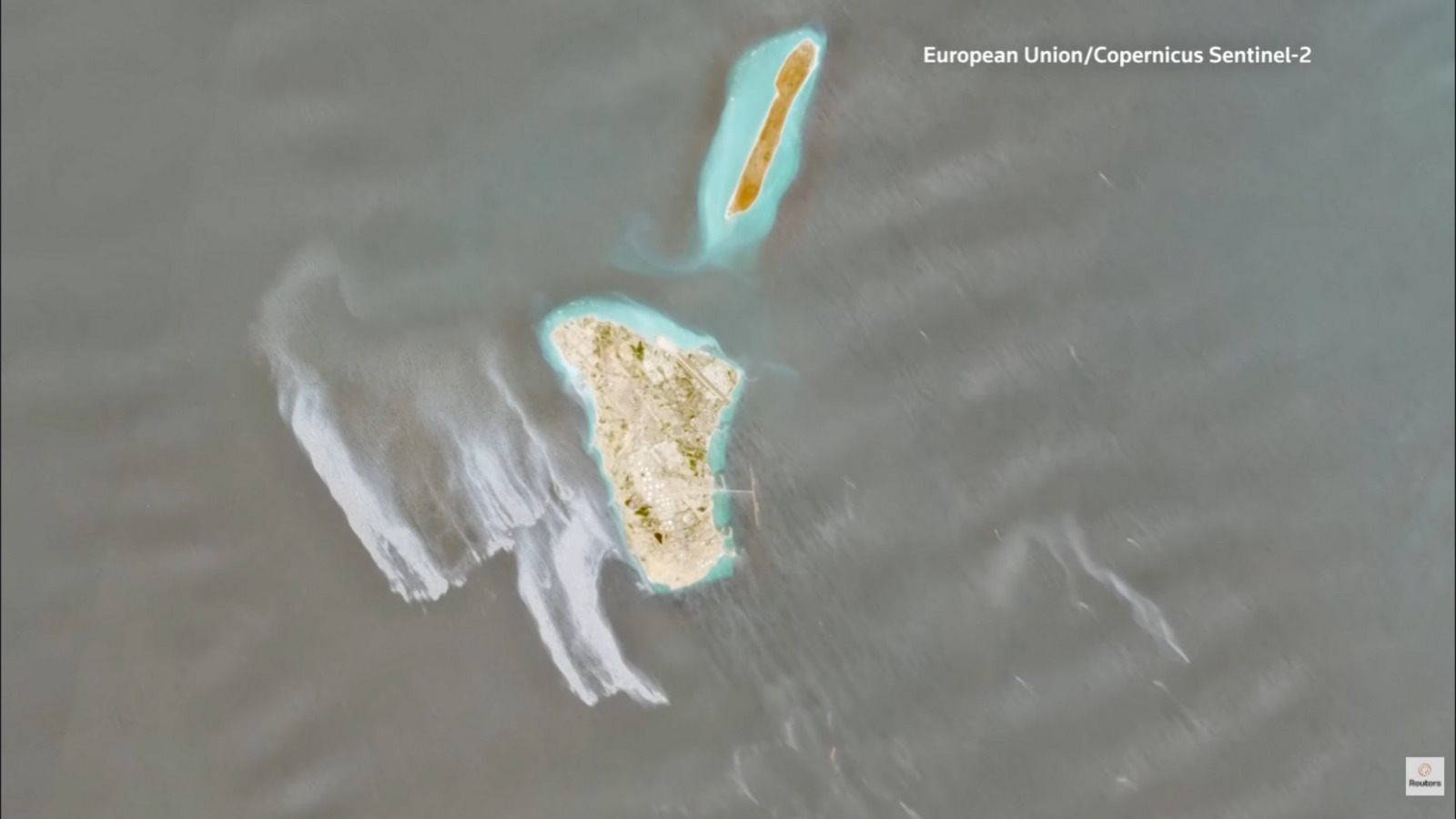
The US Armed Forces and Iran’s mission to the United Nations in Geneva did not respond to requests for comment on the images.
Goddard stated that the incident could potentially be the largest since the start of the war between the US and Israel against Iran, which began 70 days ago.
War pressures routes and supply
The US Navy blocks Iranian ports to try and prevent the entry and exit of tankers from Tehran. American and Iranian forces have also clashed in the Gulf.
-
Oil production grows in Rio, but reserve replacement raises a warning sign

-
Petrobras is expected to complete the drilling of the Morpho well in the Foz do Amazonas in August 2026, the first well in the Equatorial Margin, an oil frontier that the ANP estimates at more than 30 billion barrels and could redraw the map of Brazil.

-
Oil returns to the center of concerns with tension between the US and Iran

-
IEA reduces forecast for global oil demand in 2026 after impacts of the Middle East crisis


The war left hundreds of ships stranded in the Gulf and caused the largest global disruption in crude oil supply. The conflict also affected petroleum derivatives and liquefied natural gas.
The possible leak increases pressure on a region marked by blockades, military clashes, and energy transport bottlenecks. The oil slick remains without confirmed origin by the authorities involved.
With information from CNN.
At the beginning of the war, American forces claimed to have destroyed military targets on the island. The region regained attention after the detection of the possible leak.
Louis Goddard, co-founder of Data Desk consultancy, specializing in climate and commodities, also assessed that the images likely show an oil slick.
Cause and origin remain unknown
The cause of the possible leak and its origin point have not yet been identified. Moreland added that the May 8 images showed no evidence of other active leaks.
The US Armed Forces and Iran’s mission to the United Nations in Geneva did not respond to requests for comment on the images.
Goddard stated that the incident could potentially be the largest since the start of the war between the US and Israel against Iran, which began 70 days ago.
War pressures routes and supply
The US Navy blocks Iranian ports to try and prevent the entry and exit of tankers from Tehran. American and Iranian forces have also clashed in the Gulf.
The war left hundreds of ships stranded in the Gulf and caused the largest global disruption in crude oil supply. The conflict also affected petroleum derivatives and liquefied natural gas.
The possible leak increases pressure on a region marked by blockades, military clashes, and energy transport bottlenecks. The oil slick remains without confirmed origin by the authorities involved.
With information from CNN.
The record was made by Sentinel-1, Sentinel-2, and Sentinel-3 satellites, linked to the Copernicus program. The analyzed images cover the period between May 6 and 8.
Leon Moreland, a researcher at the Conflict and Environment Observatory, stated that the slick appears visually consistent with oil. The estimate indicates an approximate area of 45 square kilometers.
Area concentrates Iranian exports
Kharg Island holds central importance for the Iranian oil sector. The location concentrates 90% of the country’s oil exports, with a large part of these shipments destined for China.
At the beginning of the war, American forces claimed to have destroyed military targets on the island. The region regained attention after the detection of the possible leak.
Louis Goddard, co-founder of Data Desk consultancy, specializing in climate and commodities, also assessed that the images likely show an oil slick.
Cause and origin remain unknown
The cause of the possible leak and its origin point have not yet been identified. Moreland added that the May 8 images showed no evidence of other active leaks.
The US Armed Forces and Iran’s mission to the United Nations in Geneva did not respond to requests for comment on the images.
Goddard stated that the incident could potentially be the largest since the start of the war between the US and Israel against Iran, which began 70 days ago.
War pressures routes and supply
The US Navy blocks Iranian ports to try and prevent the entry and exit of tankers from Tehran. American and Iranian forces have also clashed in the Gulf.
The war left hundreds of ships stranded in the Gulf and caused the largest global disruption in crude oil supply. The conflict also affected petroleum derivatives and liquefied natural gas.
The possible leak increases pressure on a region marked by blockades, military clashes, and energy transport bottlenecks. The oil slick remains without confirmed origin by the authorities involved.
With information from CNN.
Oil slick detected by satellites near Kharg Island, center of 90% of Iran’s oil exports, emerges amidst war, naval blockades, ships stranded in the Gulf, and pressure on global supply
A possible oil slick of 45 square kilometers was identified this week near Kharg Island, Iran’s main oil area, in satellite images taken between May 6 and 8. Information from CNN and Reuters.

Images show oil slick
The probable oil slick appeared in the images as a gray and white streak over the waters west of Kharg Island, which is eight kilometers long.
The record was made by Sentinel-1, Sentinel-2, and Sentinel-3 satellites, linked to the Copernicus program. The analyzed images cover the period between May 6 and 8.
Leon Moreland, a researcher at the Conflict and Environment Observatory, stated that the slick appears visually consistent with oil. The estimate indicates an approximate area of 45 square kilometers.
Area concentrates Iranian exports
Kharg Island holds central importance for the Iranian oil sector. The location concentrates 90% of the country’s oil exports, with a large part of these shipments destined for China.
At the beginning of the war, American forces claimed to have destroyed military targets on the island. The region regained attention after the detection of the possible leak.
Louis Goddard, co-founder of Data Desk consultancy, specializing in climate and commodities, also assessed that the images likely show an oil slick.
Cause and origin remain unknown
The cause of the possible leak and its origin point have not yet been identified. Moreland added that the May 8 images showed no evidence of other active leaks.
The US Armed Forces and Iran’s mission to the United Nations in Geneva did not respond to requests for comment on the images.
Goddard stated that the incident could potentially be the largest since the start of the war between the US and Israel against Iran, which began 70 days ago.
War pressures routes and supply
The US Navy blocks Iranian ports to try and prevent the entry and exit of tankers from Tehran. American and Iranian forces have also clashed in the Gulf.
The war left hundreds of ships stranded in the Gulf and caused the largest global disruption in crude oil supply. The conflict also affected petroleum derivatives and liquefied natural gas.
The possible leak increases pressure on a region marked by blockades, military clashes, and energy transport bottlenecks. The oil slick remains without confirmed origin by the authorities involved.
With information from CNN.


Be the first to react!