Portuguese
  Spanish
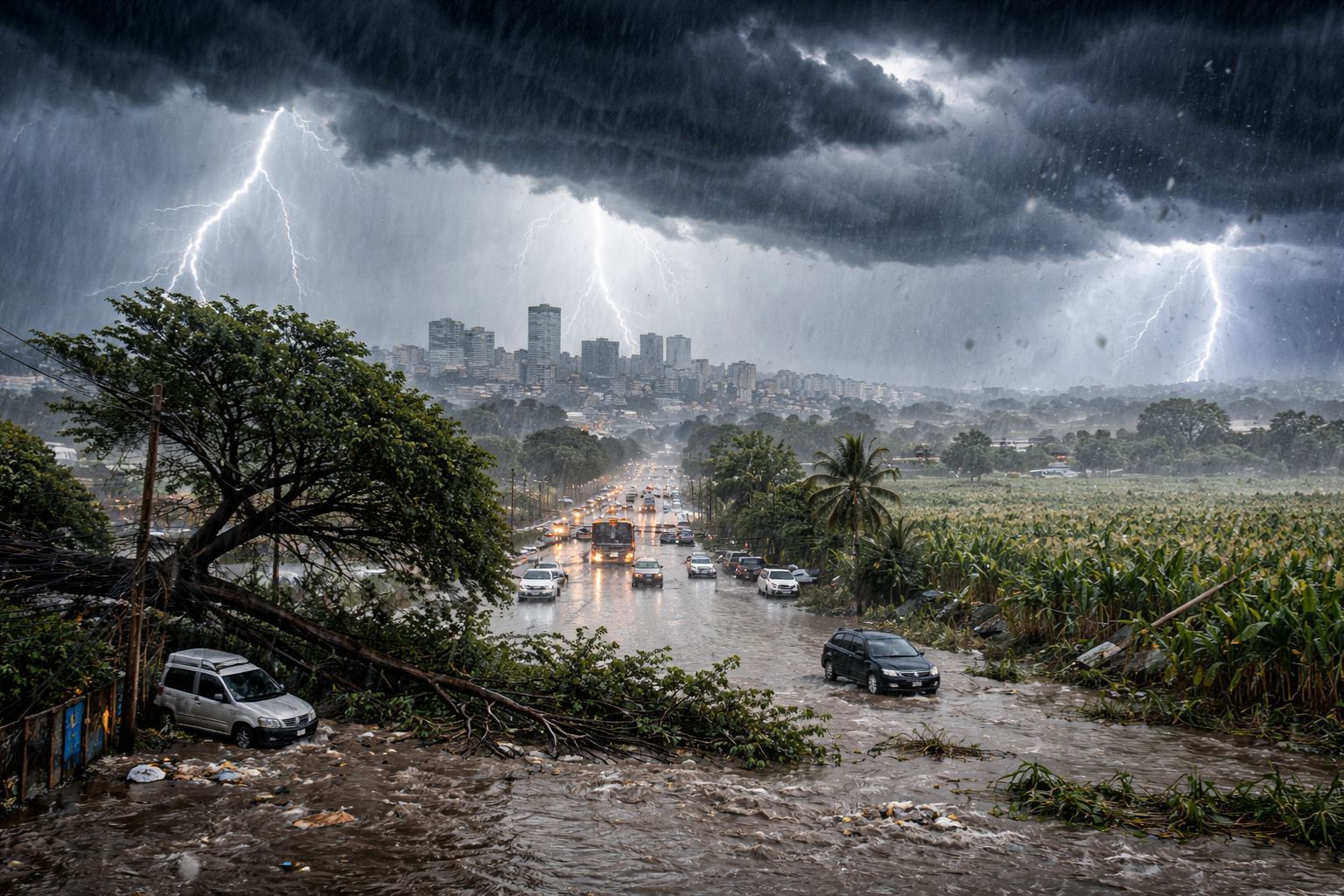
Twenty-one states in Brazil are under INMET alert this Tuesday (14), with a forecast of torrential rain that may accumulate up to 100 mm in the South region, winds of up to 100 km/h, and a risk of hail. The scenario is expected to persist for 72 hours with storms caused by a depression in high levels of the atmosphere.
The Brazil wakes up this Tuesday (14) under a meteorological scenario that requires heightened attention from north to south of the country. Twenty-one states have alerts issued by INMET (National Institute of Meteorology), and the forecast for the next 72 hours is for torrential rain capable of causing flooding, falling trees, power outages, and damage to crops. The southwest and northwest of Rio Grande do Sul will enter an orange alert for danger starting at 6 PM, with accumulations that may reach 100 mm, winds of up to 100 km/h, and a risk of hail. The scenario is caused by a depression in high levels of the atmosphere that maintains instability for long periods.
The concern goes beyond the South. In the North and Northeast of Brazil, the action of the Intertropical Convergence Zone (ITCZ) maintains frequent rains with a risk of storms, while the Southeast and part of the Midwest are experiencing the opposite situation, with stable weather, intense heat, and low humidity associated with a high-pressure system. Meteorologists from Conexão GeoClima explain that “we are not talking about an isolated event, but a persistent pattern, where the rain lasts for several hours or even days,” a scenario that requires constant monitoring in the more vulnerable areas across Brazil.
Which regions of Brazil face the greatest risk in the next 72 hours
According to information from the portal ndmais, the area of greatest danger is concentrated in the west of Rio Grande do Sul, which receives the most severe alert issued by INMET this Tuesday. The orange alert indicates a risk of intense rain with accumulations of up to 100 mm, winds that may reach 100 km/h, and the possibility of hail, a combination capable of causing significant damage to rural and urban properties. Projections from Conexão GeoClima indicate that accumulations may exceed 180 mm over a period of 72 to 84 hours in Argentina, a neighboring country that shares the same atmospheric system.
-
Scientists Convert Food Waste into Aviation Fuel, Successfully Test 50% Blend with Conventional Kerosene to Cut Emissions and Promote Sustainable Flights

-
OnePlus N6 Smartphone to Launch in India with 8,000mAh Battery and 45W SuperVOOC Charging, Lasting Up to Three Days
-
Scientists Plan to Release Air Bubbles Underwater to Protect Antarctica’s “Doomsday Glacier” from Melting

-
Chinese R6000 Drone Combines Airplane and Helicopter Features, Carries Up to 12 People for Multiple Missions


In addition to Rio Grande do Sul, INMET issues a yellow storm alert for border regions of Santa Catarina and Paraná with Argentina, as well as the south of Mato Grosso do Sul. In these states, the forecast includes winds of up to 60 km/h, rain of up to 50 mm per day, and a risk of hail. For the North and Northeast of Brazil, the ITCZ maintains persistent rains affecting states such as Amazonas, Ceará, Maranhão, Pará, and Pernambuco, several of them under orange alert. The geographical extent of the phenomenon is what makes this week particularly concerning.
The 21 states of Brazil that are under alert from INMET
The list of states under alert reveals the continental dimension of the meteorological event. In Brazil, the affected regions range from the far south to the northern border of the country. INMET has issued alerts for Acre, Alagoas, Amapá, Amazonas, Bahia, Ceará, Maranhão, Mato Grosso, Mato Grosso do Sul, Pará, Paraíba, Paraná, Pernambuco, Piauí, Rio Grande do Norte, Rio Grande do Sul, Rondônia, Roraima, Santa Catarina, Sergipe, and Tocantins. Among these, Amazonas, Ceará, Maranhão, Pará, Paraíba, Pernambuco, Piauí, Rio Grande do Norte, Rio Grande do Sul, and Roraima have areas under orange alert, the highest level issued.
The distinction between the types of alerts matters for those living in these regions. The yellow alert indicates potential danger, with rainfall between 20 and 50 mm per day and winds of up to 60 km/h. The orange alert represents real danger, with accumulations above 50 mm, winds exceeding 60 km/h, and a concrete risk of hail, flooding, and structural damage. For residents of Brazil living in hillside areas, near rivers, or in regions with a history of flooding, the orange alert requires immediate preventive measures.
What is causing the persistent pattern of rain in Brazil
The main factor behind the instability affecting Brazil is a depression at high levels of the atmosphere, a system that generates upward air movement and favors the formation of heavy clouds for prolonged periods. Unlike a conventional cold front that passes in one or two days, this configuration keeps the rain for several hours or even consecutive days, significantly increasing the risk of high accumulations and flooding in areas where the soil is already saturated.
In the North and Northeast of Brazil, the mechanism is different but the result is similar. The ITCZ, a convergence zone of winds near the equator, maintains frequent and intense rains that affect coastal and inland states. The combination of these two systems, the altitude depression in the South and the ITCZ in the North, creates a scenario where practically all of Brazil is under some level of instability, except for the Southeast and part of the Midwest, where a mass of dry air keeps the weather stable, the heat intense, and the relative humidity low.
The concrete risks for those living in alert areas in Brazil
When meteorologists talk about accumulations of 100 mm or winds of 100 km/h, the numbers may seem abstract. In practice, the effects are tangible and potentially dangerous. Accumulated rain of 100 mm in a few hours can turn streets into rivers, sweep away vehicles, flood homes in low-lying areas, and cause landslides on slopes. Winds of 100 km/h can topple large trees, tear off roofs, and destroy metal structures such as signs and coverings of gas stations.
For the agribusiness sector, which drives the economy of much of Brazil’s interior, hailstorms represent the most feared risk: a hail shower lasting just a few minutes can destroy an entire crop that took months to grow. Prolonged power outages are also expected in rural areas, where transmission lines are more vulnerable to falling branches and dust. INMET’s recommendation is that residents of affected areas avoid traveling through flooded locations, stay away from trees and metal structures during storms, and monitor alert updates.
What to expect for the rest of the week in Brazil
The persistent pattern of rain is expected to continue until at least Thursday (16), when the depression at high levels will begin to weaken over Southern Brazil. However, the ZCIT will remain active over the North and Northeast, which means that states like Amazonas, Pará, Maranhão, and Ceará may face heavy rains throughout the week. The Southeast remains under the influence of a dry air mass, with elevated temperatures and relative humidity that may drop below 30% in some cities in São Paulo and Minas Gerais.
For those living in alert areas, the next practical decision is to prepare for the worst and hope for the best. In case of emergency, the Civil Defense numbers (199) and Fire Department (193) should be contacted immediately. Removing loose objects from yards, unplugging devices during thunderstorms, and having an emergency backpack with documents and medications are simple measures that can make a difference when the storm arrives. Brazil is under alert, and the best response to an alert is preparation.
Twenty-one states in Brazil are under alert for torrential rain, hail, and strong winds in the next 72 hours. Do you live in any of the affected regions? Have you felt the effects of the rains? Tell us in the comments how the weather is in your city.