
 Portuguese
  Spanish
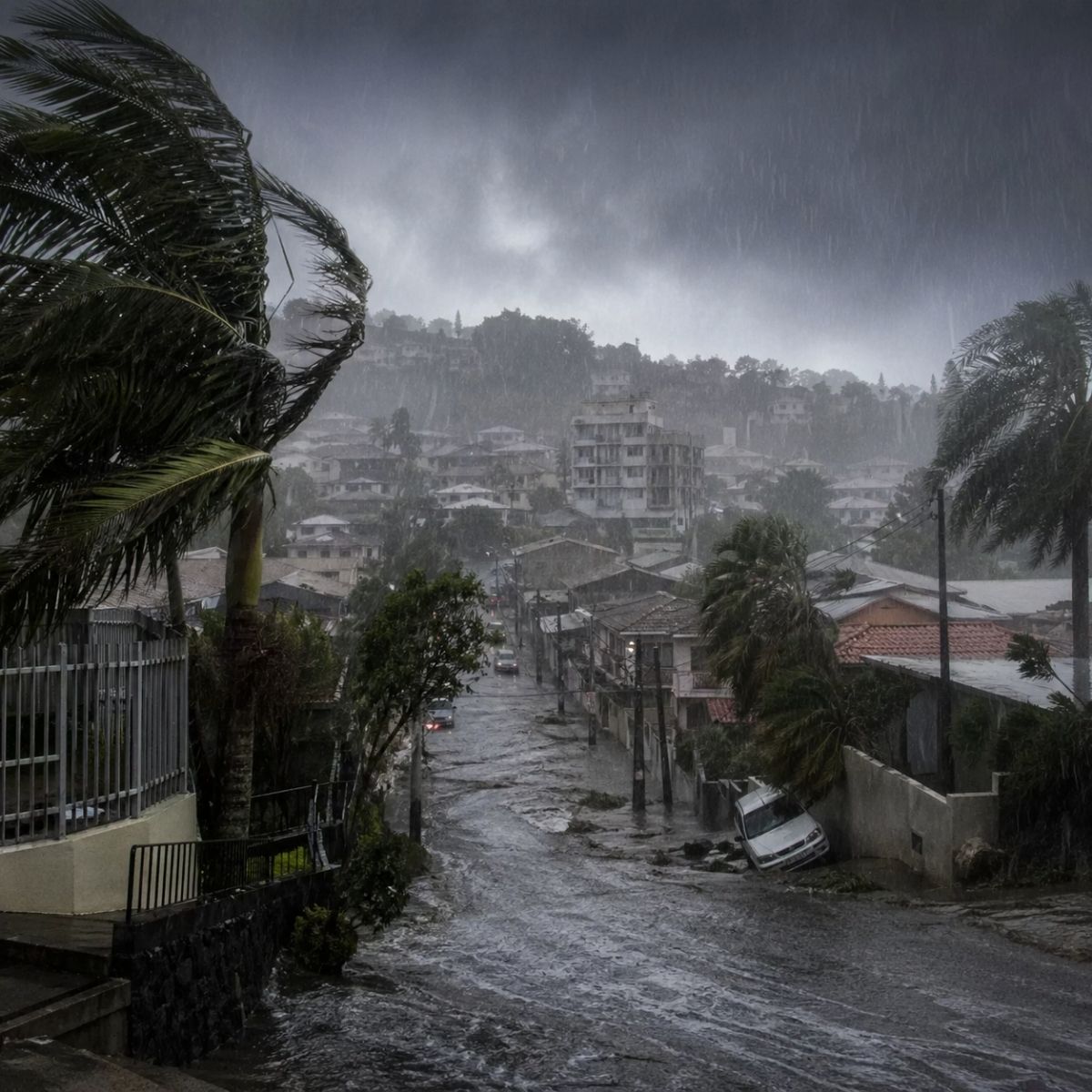
Santa Catarina Civil Defense issued a storm alert valid between Tuesday (28) and Wednesday (29) for intense rain with wind gusts, lightning, and hail, with risk of flooding in the North Coast and Lower Itajaí Valley, right after the coldest dawn of 2026 with frost in the Santa Catarina Mountains.
The Civil Defense placed Santa Catarina on alert for a storm that may affect several regions of the state between Tuesday night (28) and Wednesday night (29), a sudden change that occurs just hours after the coldest dawn of 2026. The warning issued by the Civil Defense indicates a low to moderate risk of occurrences associated with floods, localized flash floods, falling branches and trees, roof damage, and damage to the electrical grid, a scenario that requires extra attention from residents in areas vulnerable to water accumulation and landslides. The same cold air mass that dropped temperatures to minus 3.3°C in São Joaquim on Tuesday morning brings with it atmospheric instability that will intensify on Wednesday, favoring heavy rain accompanied by lightning, wind gusts, and the possibility of hail in isolated spots.
Climate contrast is the hallmark of this week in Santa Catarina. On Tuesday morning, the Santa Catarina Mountains awoke covered in frost with the lowest temperatures of the year, and less than 24 hours later the state may face storms capable of causing floods and falling trees, a transition that the Civil Defense classifies as typical of autumn, a season where summer and winter characteristics alternate without warning. Epagri/Ciram monitoring confirmed that São Joaquim registered minus 3.3°C and that several mountain regions awoke covered in ice, a scenario that gave way to heavy clouds throughout the day as humidity began to return.
Which regions does the Civil Defense identify as most vulnerable to the storm

The North Coast and the Lower Itajaí Valley are the areas where rain may be more persistent and the risk of flooding is higher. These regions concentrate rivers that historically overflow during episodes of intense precipitation, and the combination of soil saturated by previous rains and the additional volume expected for Wednesday creates favorable conditions for a rapid rise in water levels in urban areas with insufficient drainage. The Civil Defense monitors river behavior and issues updates as precipitation data is confirmed or changes in the coming hours.
-
Half of Brazil’s Federal Public Works Projects Stalled: Audit Reveals 11,469 Abandoned Constructions and Billions Spent Without Delivering Schools, Hospitals, or Roads
-
End of an Era: Major Company Shuts Down Factory After 64 Years, Leaving Over 150 Unemployed; Facility Produced 85,000 Tons Annually of Essential Tire Material
-
End of an Era: Major Company Shuts Down Factory After 64 Years, Leaving Over 150 Unemployed; Facility Produced 85,000 Tons Annually of Essential Tire Material
-
End of an Era: Major Company Shuts Down Factory After 64 Years, Leaving Over 150 Unemployed; Facility Produced 85,000 Tons Annually of Essential Tire Material
The other regions of Santa Catarina are also under observation. The map released by the Civil Defense shows areas in yellow where the risk is higher and areas in green that are under continuous monitoring, indicating that even localities outside the main alert zone can be surprised by isolated storms that form quickly and dump significant volumes of water in a short period. The nature of autumn storms is precisely this unpredictability: the system can gain or lose strength as it interacts with the topography and air currents circulating over the state.
What the Civil Defense recommends the population do during the storm
The Civil Defense guidelines are direct and should be followed by those living in risk areas. In case of intensifying winds, the recommendation is to seek shelter and stay away from trees, billboards, power poles, and any object that could be torn off and thrown by gusts. Drivers should avoid driving on flooded streets because the water depth is not always visible and a few centimeters can be enough to sweep away a vehicle, and pedestrians should stay away from streams and canals that can overflow in minutes during heavy rain.
For residents of slopes and riverside areas, even greater attention is needed. The Civil Defense advises that signs such as cracks in the ground, leaning poles or trees, muddy water coming out of the terrain, and unusual noises coming from the ground indicate the possibility of landslides or flooding and should prompt immediate evacuation to a safe location. Contact with the Civil Defense can be made by calling 199 in any municipality in Santa Catarina, and it is ideal to contact the agency before the situation worsens rather than waiting until escape becomes risky.
Why cold weather and storms appear together in Santa Catarina this week

The sequence of extreme cold followed by a storm is no coincidence: both phenomena are caused by the same polar cold air mass that advanced over Santa Catarina. The arrival of the polar mass dropped temperatures on Tuesday morning and created frost conditions in the Serra, but as this cold air meets the humidity coming from the ocean and the warm air currents that still persist over the coast, the atmosphere becomes unstable and generates the storms that the Civil Defense announces for Wednesday. It’s as if the same meteorological system produces two opposite effects in sequence: first it freezes, then it unloads.
Santa Catarina’s Civil Defense issued an early warning on Monday (27) alerting to a sharp drop in temperature that was confirmed on Tuesday, and now updates the alert to include the storms expected between Tuesday and Wednesday. This early communication is essential because it allows the population to prepare while there is still time, and the experience of previous events shows that deaths and damages in storms are directly associated with the lack of preventive action by those who receive the alert but choose to ignore it. Civil Defense fulfills its role by issuing warnings; the responsibility to act according to the guidelines falls on each citizen.
What to expect from the weather in Santa Catarina after Wednesday’s storm
The trend for the rest of the week is gradual stabilization. After the passage of the system causing Wednesday’s storms, Santa Catarina should see improvement with a reduced risk of flooding and wind gusts, as well as a decrease in cloudiness and a return to milder afternoon temperatures, although mornings will remain cold with lows between 10°C and 15°C in most of the state. Civil Defense will continue to monitor conditions and issue new alerts if the scenario changes, but the expectation is that the worst of the instability will be concentrated between Tuesday and Wednesday.
For those planning outdoor activities in the coming days, the Civil Defense recommends following updates through official channels before leaving home. The Santa Catarina Civil Defense app and the agency’s social media channels publish real-time information on meteorological conditions and specific alerts by municipality, a tool that allows informed decisions to be made about travel and activities that can be postponed if the risk justifies it. The predicted storm is temporary, but the damage it can cause is permanent for those who are unprepared.
And you, do you live in a region that is under Civil Defense alert? Have you already taken precautions for Wednesday’s storm? Leave your opinion in the comments.


