Portuguese
  Spanish
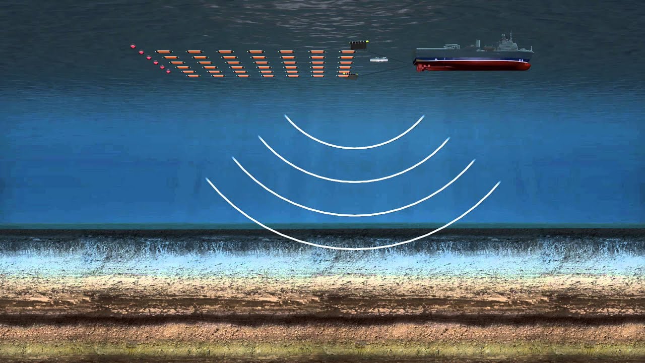
Does Most of the Modern Brazilian Industry Use Fossil Fuels from Offshore Discoveries? But Do You Know the Technology to Find Oil and the Types of Operations Involved?
Seismic research consists of conducting an oceanographic ultrasound, performed through sound waves captured by seismic cables, with the aim of finding oil and gas reserves in the seabed.
The vessels used in this research are ships that carry a series of necessary research equipment, such as compressed air sources, which emit low-frequency sound waves that travel to the ocean floor and return to the surface, being captured by the ship’s seismic cables. These signals are interpreted and generate geophysical data that allow for the analysis of the seabed, thus identifying areas with the highest chances of containing oil and gas reserves. The seismic ship contains several storage locations (for seismic cables, compressed air bottles, and others), a hangar, workshops, a large operational area, and laboratories with different functions.
-
Over 2,000 Tons of Discarded Fishing Nets Since 2020 Repurposed into Durable Caps, Fins, and Parts

-
Seals and Sea Lions Lose Habitat and Food as Climate Change Advances, Impacting Ice, Prey, and Coastal Communities

-
Brazilian Innovator Uses 3D-Printed Device to Cool Two Rooms with One Air Conditioner
-
China Uses 432 Robots to Move a 7,500-Ton Historic Building in Shanghai, Preserving Architecture While Creating Space for Underground Center


There are few ships of this type. This in practice means that the information available about this type of ship is not extensive.
Seismic research is the first step to be carried out in the chain of activities developed for exploring and producing oil. It consists of mapping and recognizing the various layers that make up the seabed.

Curiosity: Sharks Can Bite the Cable, Disrupting the Accurate Reading and Interpretation of Seismic Data
Second Officer of Navigation, Michel Ribeiro, reports something interesting, let’s put it in quotes so you can understand the account:
“Excellent work! I had the opportunity to work on a seismic ship from CCG ALIZE. These seismic cables have a very high economic value, millions of dollars each. We went out to make repairs on the birds, which are the depth controllers. The energy that passed through the cables caught the attention of sharks that would bite pieces off the cables, creating a reading failure at the specific location where they attacked. For me, it was a pleasure to have to change the birds, we would go by speedboat to make the swap. A truly wonderful experience!”
Source: Rafaela Bezerra, Technologist, Technician in Chemistry and Construction. Reference for technical details: Oceânica UFRJ.