
 Portuguese
  Spanish
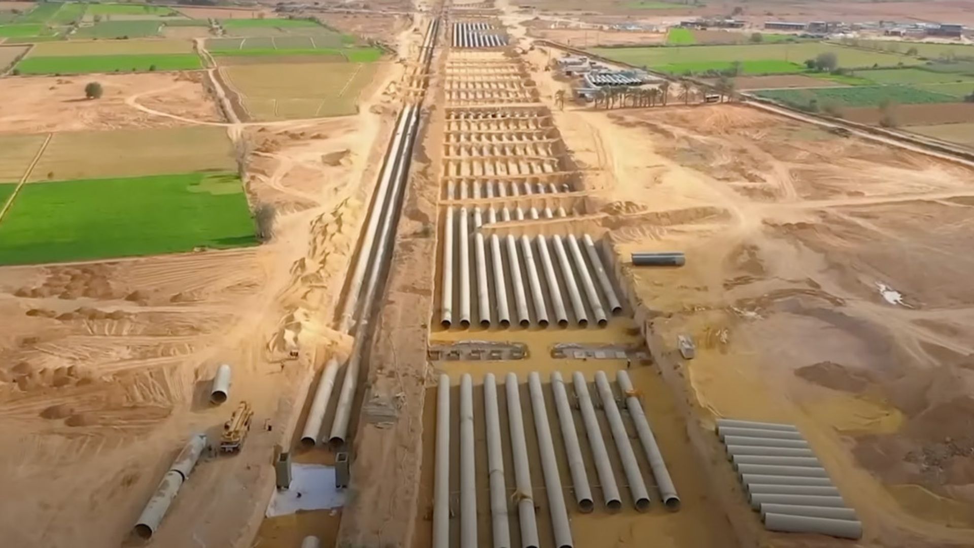
Water Corridor Advances Through The Egyptian Desert And Redefines Water Use Outside The Nile Valley, With Heavy Engineering, Digital Control, And State Investment To Expand Agricultural Areas And Reduce Demographic Pressure Concentrated In Less Than 5% Of The National Territory.
A water corridor built in the western desert of Egypt is becoming the centerpiece of the New Delta Project, a government initiative to bring irrigation and expand agricultural areas outside the traditional Nile strip.
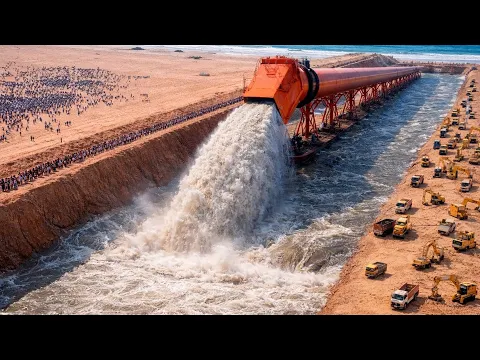
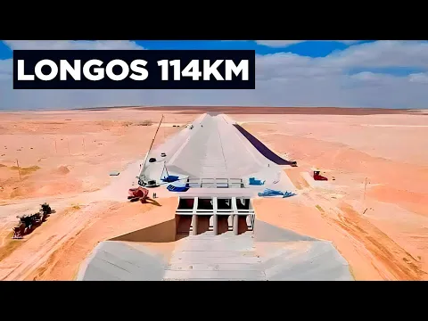
The work is described in materials and technical reports about the project as an artificial “river” approximately 114 kilometers long, formed by an open canal and sections in large-diameter pipes, in addition to reservoirs, sluices, and pumping stations.
The goal is to transform arid areas into production hubs, using water from the Nile system and, above all, treated agricultural drainage and sewage water.
-
Billionaire says the most valuable skill will help overcome job elimination caused by AI, following Bill Gates’ fears

-
A Dutchman created a ‘box’ that makes trees grow in the desert almost without water and without irrigation: the invention has already brought seedlings to dozens of countries and achieves up to 90% survival where common planting did not exceed 10%.

-
Abandoned warehouse hid a giant collection of rare computers, with over 2,000 artifacts from the 1930s to the 1980s.
-
Scientists warn that melting ice is triggering an alarming chemical transformation in preserved areas, and the first signs are already concerning researchers worldwide.


By relocating part of the water infrastructure to the west, Egypt is trying to address an increasingly tight equation: growing population and limited arable land concentrated near the river.
World Bank data indicates that the country had 116.5 million inhabitants in 2024, a number that helps explain the pressure on housing, services, and food security.
Why The New Delta Became A Strategic Priority
The image of Egypt is often associated with monuments of the past, but geography imposes very current limits.
With large desert areas and most agricultural activity historically concentrated in the Nile valley and delta, agricultural expansion projects have come to be viewed as strategic for internal supply.
In this context, the New Delta was presented as a set of works to recover land, create water infrastructure, and support new productive settlements.
One of the bases of the plan is to reuse water.
Instead of solely relying on direct capture from the Nile, the system includes volumes of treated water, especially from the El Hammam station, cited by companies and organizations linked to the engineering of the project as one of the largest treatment complexes in the world.
The announced capacity reaches 7.5 million cubic meters per day.
Where The Water Comes From And How It Crosses The Sahara
The route disclosed for the water corridor connects capture and treatment points to a transport grid that combines open canal and long pressurized sections.
In specialized reports on the subject, the so-called “second canal” associated with the El Hammam station appears with about 170 kilometers of total length, carrying millions of cubic meters per day towards the planned agricultural areas south of the Dabaa region.
In practice, the logic is to distribute water by gravity when possible.
When necessary, pumping stations come into operation to overcome elevation changes and maintain stable flows.
This design also explains the presence of intermediate reservoirs, which function as regulators to reduce sharp fluctuations and provide predictability to supply at different points in the network.
Heavy Engineering Against Sand And Extreme Heat
The described construction relies on a sequence of typical steps for large canals: earthworks, subgrade stabilization, bed excavation, and waterproofing.
In the desert, the additional obstacle is the mobility of the terrain, with dunes that change shape and the natural tendency of sandy soil to drain water quickly.
Therefore, the work is described as a continuous operation of leveling, compaction, and altitude control along the canal axis.
Frequent topographic checks are used to maintain the slope within the expected range, even over long stretches in the open desert.
The choice of a U-shaped section and large widths meets the objective of safely transporting high volumes with hydraulic security.
When the topic shifts to waterproofing, the logic is to reduce losses due to infiltration and protect the canal against erosion.
The solution combines concrete slabs, expansion joints, and sealing, in addition to the use of plastic membranes in sections considered more vulnerable from a geotechnical standpoint.
The technical argument is straightforward: without a good lining, a significant portion of the water can be lost along the way, compromising the system’s efficiency.
There is also concern about heat as a response to the environment.
On days when maximum temperatures in the desert exceed 45°C, the expansion of materials and wear of structures accelerate, which explains the use of joints, sealants, and protective layers.
Sensors, Satellites, And Digital Water Management
Another axis of the project is intelligent water management.
The network is described as being equipped with level, pressure, and flow sensors, in addition to remote monitoring, including by satellite.
These data allow the operation of pumps to be automated and the distribution adjusted according to demand.
The stated objective is to reduce waste, quickly detect leaks, and improve energy efficiency.

This type of control gains relevance in an extensive grid and hostile environment, where physical access to all points is costly and time-consuming.
At the same time, the intensive use of pumping and treatment raises energy and operating costs, making operational efficiency a central aspect of the project’s viability.
New Agricultural Frontier Seen From Space
With water reaching previously unproductive areas, the most visible agricultural design is that of center pivot irrigation, which forms large green circles observable in satellite images.
NASA records indicate the expansion of irrigated areas west of the Nile delta, associating this growth with the effort to bring water and infrastructure to the New Delta region.
The text also describes the creation of integrated agriculture and livestock complexes, planned industrially.
Confinement structures, production of feed from local crops, and self-sufficient water supply are part of the model.
The proposal is to reinforce the domestic food supply and reduce external dependencies, although the results depend on factors beyond engineering, such as costs, logistics, type of crop, and water availability in the long term.
At the center of the project is the attempt to shift part of the economic and population growth outside the narrow corridor of the Nile.
By opening a new agricultural frontier in the desert, Egypt bets that infrastructure, technology, and water management can redefine the historical limits of the territory.


Seguro que sise balaha quiere acercar el agua del nil a los sioni…
12 trabajadores! Para tamaña obra, o son parientes de Superman o la noticia no esta bien chequeada!! Igualmente estan obras vanguardistas dejan mal parados a los lideres del resto del mundo
Uma obra necessaria. A busca d saidas precisa ser mantida em qualquer tempo. se tem a necessidade e competencia para execuçao . Tem mais é q acontecer.