

 Portuguese
  Spanish
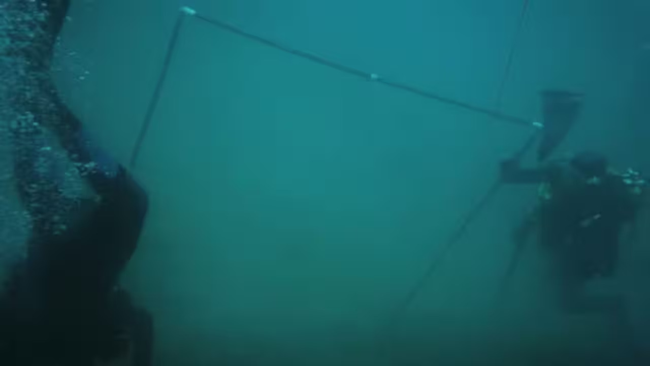
Discovery of Wreckage on Madagascar Island Confirms Shipwreck of Portuguese Vessel Nossa Senhora do Cabo, Lost in 1721 After Pirate Attack
An archaeological discovery in 2025 revealed an important chapter in Portuguese naval history. Researchers announced the probable location of the ancient warship Nossa Senhora do Cabo, lost over three centuries ago.
The vessel was identified near Nosy Boraha, a small island off the east coast of Madagascar, shedding light on a tragedy that occurred in 1721.
The finding was conducted by the Center for Historic Shipwreck Preservation, based in Massachusetts, United States.
-
A doctor from Minas Gerais warns that sleeping with the fan pointed at the body all night is not as harmless as you think; it dries out the respiratory tract, causes mucus buildup, spreads dust mites, and can even irritate the cornea of the eyes.

-
Ecuadorian volcano at 6,268 meters is more than 2,000 meters closer to space than Everest, which is 8,848 meters, because the Earth is wider at the equator.
-
Public school students in the hinterlands of Maranhão create a bioinsecticide with neem and castor to protect corn crops, transform rural waste into biogas and biofertilizer, and bring sustainable technology to producers at ExpoSertão.

-
Ötzi, the 5,300-year-old mummy found in the Alps, reveals a still active microbiome, and the Iceman’s yeast points to an energy-saving fermentation.


To reach the identification, specialists analyzed historical documents, hull structures, and artifacts found at the wreck site.
The discovery drew attention not only for the value of the cargo carried but also for the context of navigation and the actions of pirates in the region.
Mission and Valuable Cargo of Portuguese Vessel
The Nossa Senhora do Cabo departed from Goa, an old Portuguese colony in India, in early 1721. Its destination was Lisbon.
The vessel was carrying a large amount of wealth, including bars of gold and silver, jewelry, textiles, and religious objects.
Additionally, important figures were onboard, such as the Portuguese viceroy of Goa, the archbishop of the city, and about two hundred enslaved people from Mozambique.
The estimated value of the cargo in today’s terms is €138 million. These goods represented the commercial interests between East and West.
They were also part of the Portuguese strategy to maintain colonial power and supply the court amidst maritime disputes and the constant risk of piracy.
Pirate Attack After Storm
On April 8, 1721, the ship was struck by a severe storm near Réunion Island. To avoid shipwreck, part of the cannons had to be thrown overboard, drastically reducing its defense capacity. In this moment of vulnerability, pirates attacked the vessel.
The area of Nosy Boraha, then known as Île Sainte-Marie, was known to harbor European pirates.
The absence of oversight and the strategic position made the location a point of interest for looters.
After the invasion, the pirates stole some of the goods, and according to reports, intentionally sank the ship to erase the traces of their crime.
Archaeological Finds at the Wreck Site
More than 3,300 items have been removed from the site since the beginning of the excavations. Among the recovered objects are gold coins with Arabic inscriptions, porcelain, religious icons, and an ivory plaque with golden details. It reads “INRI,” a reference to the Latin inscription attributed to Jesus of Nazareth.
A large part of the wreckage is covered by sand and sediment, which may hinder further excavations.
Nevertheless, the recovered items already provide important clues about commerce, religion, and customs of that time.
Uncertain Fate of the Crew and Stolen Goods
It is still not clear what happened to all the crew members. The viceroy was freed after a ransom was paid.
However, the fate of the enslaved people and the archbishop remains unknown. Some of the treasures remained on the seabed and nowadays make up the collection of artifacts recovered by archaeologists.
There are also indications that other ships looted by pirates sank near the same area of Nosy Boraha.
This possibility has kept the interest of the scientific and archaeological community for future expeditions in the Indian Ocean.
Impact of the Discovery on Historical Maritime Routes
The location of the wreckage of the Nossa Senhora do Cabo helped confirm ancient accounts about the routes chosen by Portuguese navigators.
The presence of the ship near Madagascar reinforces the thesis that the Mozambique Channel was a strategic passageway.
Factors such as winds, ocean currents, and pirate attacks directly influenced commanders’ decisions.
As a result, researchers are reviewing old nautical maps and updating studies on trade between Europe, Africa, and Asia in the 18th century. The role of regions like Île Sainte-Marie gains new importance in this context.
Advanced Technology in Wreck Investigation
Archaeologists used various modern technologies to examine the wreckage. Among them are side-scan sonar, remotely operated vehicles (ROVs), and carbon dating methods.
These tools allowed for the identification of hull fragments, personal items, and parts of the deck structure in deep and sediment-covered areas.
The combination of these tools with historical records made it possible to achieve one of the most complete reconstructions of a colonial shipwreck in the Indian Ocean.
The data obtained also help understand shipbuilding techniques and maritime transport habits of the 18th century.
A Discovery That Reinforces the Value of Historical Research
The location of the Nossa Senhora do Cabo represents a significant advancement in maritime archaeology. In addition to providing answers about a little-documented shipwreck, it sheds light on aspects of trade routes, colonial conflicts, and social practices of that period.
Even with many questions still unanswered, the recovery of artifacts and the confirmation of the wreck site contribute to expanding knowledge about the Portuguese presence in the Indian Ocean and the role of pirates in 18th-century naval history.
With information from Portal Uai.


Be the first to react!