
 Portuguese
  Spanish
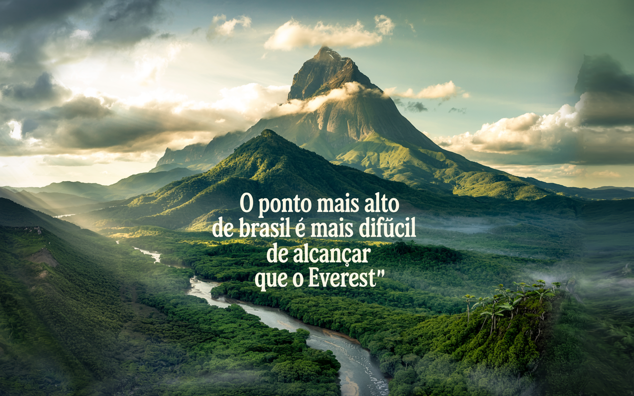
The Pico Da Neblina Is The Highest Point In Brazil, At 2,995 Meters, But Its Access Is So Challenging That It Surpasses Even Everest In Logistical Difficulty. Understand Why Few Manage To Get There.
Few people know, but the highest point in Brazil is not in the Mantiqueira Mountains, nor is it visible from tourist highways or famous peaks like Itatiaia. The Pico da Neblina, at an impressive 2,995 meters altitude, is embedded in the heart of the Amazon Rainforest, surrounded by dense vegetation, rushing rivers, and indigenous territory. Located in the far north of the state of Amazonas, within the Pico da Neblina National Park, accessing this mountain requires physical preparation, special authorization, and days of hiking through one of the most isolated regions of the country.
For many, climbing Everest is an extreme goal, but logistically feasible, with established infrastructure and dozens of commercial expeditions each year. On the other hand, the Pico da Neblina presents unique challenges that make its visit a true Amazonian expedition — more difficult than reaching the top of the world, according to mountaineering and adventure experts.
Today you will learn about the history, geography, challenges, legal requirements, and the future of adventure tourism in the highest place in the national territory.
-
Thailand Converts 8 Tons of PET Bottles into 3,500 School Backpacks, Showcasing Circular Economy with Over 40 Factories Involved

-
Mysterious Bats Spotted in Paris’s Père Lachaise Cemetery, Drawing Tourists to the “Vampire Cemetery”

-
From Selling Street Food to Leading a $300 Million Construction Firm: The Journey of a Brazilian Entrepreneur

-
Abandoned Penthouse in Houston Reveals Million-Dollar Suite with 24-Karat Gold, Tiffany Crystals, and Opulence Even Elvis Might Have Snubbed


Where Is The Pico Da Neblina Located?
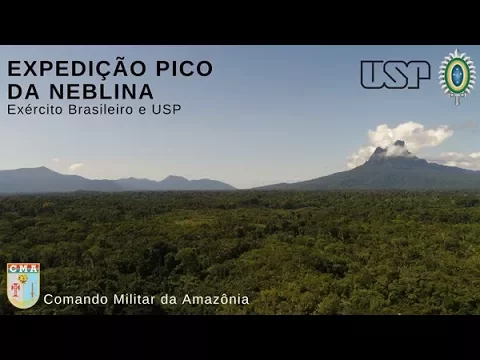
The Pico da Neblina is located on the border between Brazil and Venezuela, within the municipality of São Gabriel da Cachoeira (AM), about 220 km west of the municipal seat. The mountain lies in the Pico da Neblina National Park, created in 1979 by the Chico Mendes Institute for Biodiversity Conservation (ICMBio), and is part of the Imeri Mountain Range, in the Guiana Highlands.
The site is located within Yanomami indigenous lands, one of the regions with the highest environmental preservation in the world and access controlled by federal regulations and agreements between ICMBio and Funai.
The Official Altitude Of Pico Da Neblina

For decades, it was believed that the Pico da Neblina was 3,014 meters high, but in 2004, IBGE, using GPS technology and satellite images, updated the data: its actual altitude is 2,995.30 meters. Even so, it remains the highest point in Brazil, surpassing the neighboring Pico 31 de Março, which reaches 2,974 meters.
Why Is It Harder To Reach Than Everest?
In technical terms, Everest is taller and requires extreme physical preparation, but its access is facilitated by established infrastructure, commercial flights to Kathmandu, well-marked trails, and constant presence of local guides, sherpas, and temporary shelters. The Pico da Neblina, while being nearly 6 km lower, requires:
- Prior authorization from ICMBio and Funai;
- Organized expeditions with accredited guides and Yanomami translators;
- River transport to the trailhead;
- Hiking for up to 10 days through dense jungle, with river crossings and steep climbs;
- Strict sanitary and environmental controls.
In other words: the obstacle is not altitude, but the logistical access and cultural and environmental preservation of the region, which imposes significant limitations on conventional tourism.
Restricted Access: What Is Required To Visit The Pico Da Neblina?
Since 2003, access to the Pico da Neblina has been completely closed as a way to preserve the Yanomami indigenous peoples and the forest ecosystem. Only in 2019 was an agreement signed between ICMBio, Funai, and indigenous associations for the gradual reopening of tourism visits — under strict rules and focusing on sustainable tourism.
Current Rules (Official Data From 2024):
- Visiting the peak is only allowed with agencies accredited by ICMBio and with a mandatory Yanomami guide.
- It is necessary to fill out forms, pay environmental fees, and obtain formal authorization.
- Groups are limited to about ten visitors at a time, with a predefined schedule.
- The itinerary takes about 15 days, with 10 days of intense hiking, wild camping, and survival food.
Typical Expedition Itinerary To The Pico Da Neblina
- Arrival in São Gabriel da Cachoeira (AM) – By air from Manaus.
- River transport to the Yanomami base, on the Cauaburi River.
- Trail through the Amazon jungle, passing through:
- Imeri Base
- Tucano River
- Waterfalls
- Indigenous Camps
- Arrival at the base of Pico da Neblina
- Final ascent to the summit, with 2 days of acclimatization and climbing
- Complete return, by the same path
Yanomami Culture And The Importance Of Preservation
The territory where Pico da Neblina is located belongs to the Yanomami People, one of the last recently contacted peoples in Brazil, with culture, language, and spirituality strongly linked to the land.
The reopening of the peak for tourism was only possible with the direct involvement of indigenous leaders, who participate in the management, oversight, guiding, and even the logistical operation of the expeditions. All visits include respect for rituals, local customs, and cultural protocols, and it is prohibited to:
- Take photos without authorization;
- Make commercial recordings without permission;
- Discard trash or alter the natural environment.
Geography And Biodiversity Of Pico Da Neblina
The region of Pico da Neblina houses one of the richest biodiversities in the world, with plant and animal species exclusive to the Imeri Mountain Range. The altitude creates a microclimate of cloud forest, with:
- Temperatures between 5 °C and 15 °C at the summit;
- High humidity and constant fogs;
- Endemic species of orchids, bromeliads, and colorful frogs;
- Presence of jaguars, howler monkeys, and extremely rare birds.
It is a true biological sanctuary — which explains the strict visitation rules.
The Pico Da Neblina In Brazilian Mountaineering
Despite the difficulties, the Pico da Neblina is a symbol of overcoming for Brazilian mountaineers. Unlike Andean or Himalayan peaks, conquering it demands less about altitude and more about:
- Physical and mental resilience;
- Resistance to humidity and Amazonian heat;
- Adaptation to a remote environment, without signal, without external support.
Experienced mountaineers report that reaching the top of Brazil is more challenging than many peaks above 6,000 meters due to the jungle, mud, and isolation.
Adventure Tourism And Economic Impacts
With the controlled resumption of visits, new opportunities arise for Yanomami communities, such as:
- Income generation through guiding and rustic lodging;
- Preservation of ancestral knowledge;
- Strengthening territorial protection against illegal invaders.
Additionally, responsible ecotourism can attract international attention to protected Amazon — a real alternative to predatory extraction and illegal mining.
The Pico da Neblina is not just the highest point in Brazil: it is a symbol of the complexity of the national territory, where extreme nature, ancestral culture, and public policy intertwine in an unparalleled logistical challenge. Climbing it is not only a geographical achievement but a dive into the soul of the Amazon — requiring preparation, respect, and connection.
For adventurers seeking more than a photo at the summit, the Pico da Neblina represents one of the most intense and transformative experiences on the planet. A tourism that transforms, preserves, and rescues the relationship between human beings and the Earth.
Consulted Official Sources
- Chico Mendes Institute for Biodiversity Conservation (ICMBio)
- Brazilian Institute of Geography and Statistics (IBGE)
- Brazilian Ministry of Tourism
- Funai – National Foundation for Indigenous Peoples
- Professional expeditioners and authorized reports (mountaineers certified by CBME)


Mensagem top. Ao mesmo tempo que fala sobre os guias e sobre as oportunidades dadas com a abertura do turismo, também enfatiza os riscos e perigos, pode ir até determinado ponto e ficar ou tem que ir até o final sem direito de desistir? Vai que o guia que leva é o mesmo que trás, por hora só título de curiosidade mesmo rsrs.
E os montes onde caem neve no Brasil não mora ninguém. Densidade democrática muito baixa, Urupema em SC tem 2.500 pessoas. E não vale a pena conhecer. É chato, não tem nada.
Á MATÉRIA não menciona se é ou não utilizada pelas nossas forças armadas;Talvez se então esperar gue outros países entrem aqui é pessam licença aos índios para instalar RADARES DE DEFESAS E CLIMAS ETC…
Como afundaram o porta aviões SÃO PAULO de vez de instalar um mini quatel móvel ou fixo ou hospital ou base aérea de elicoptero marinha é e assim que nossa AMAZÔNIA (FICA AS MOSCAS).desabafo de um (PE) uma vez PE sempre PE.
Conheço lá, município de São Gabriel da Cachoeira, AM. A fronteira e o município tem bases do Exército e não são aqueles meninos branco e magrelos de cidade não. São soldados indígenas espertos, fortes e treinados, conhecem a floresta com palma da mão. O puco da Neblina está numa reserva, não é pra qualquer mochileiro-enzo se aventurar. As fronteiras do AM com Venezuelana tem bases militares, base maior em Manaus companhia de selva (CIGS), a fronteira com Colômbia tem base milita Brasília, na tríplice fronteira (Brasil-Colombia-Peru) tem base Exército,Marinha e Aeronáutica, município de Tabatinga, AM. Há caças supersônicos da FAB o tempo todo sobre os seus da Amazônia inclusive abatendo monomotor de tráfico de outros países.
Como sería levado para lá um porta aviões da envergadura do São Paulo? De helicóptero?