
 Portuguese
  Spanish
Abrupt weather change expected to surprise tourists on the São Paulo coast during the holiday, with heat initially and intense storms on Sunday, including heavy rain, strong winds, rough seas, and a sharp drop in temperature in a short period.
The extended Labor Day holiday begins with predominant sun and heat on the São Paulo coast, but the forecast indicates a **marked change in weather between Saturday, May 2, and Sunday, May 3**, requiring attention due to the rapid transformation of atmospheric conditions.
With the approach of meteorological systems coming from the South of the country, **a cold front associated with an extratropical cyclone** is expected to advance along the coast, causing heavy rain, lightning, wind gusts, and a significant change in sea conditions throughout the weekend.
Given this scenario, residents, tourists, and drivers circulating through Baixada Santista, the North Coast, and mountain regions need to redouble precautions, as Sunday concentrates the most critical period, with potential for high accumulated rainfall in a short interval.
-
Federal Police involved in the case to identify the person responsible for hacking the Civil Defense system, which sent ten false alerts, frightened residents of different capitals, and turned messages about real risks into notifications with “misanthropy” and even alien attacks.

-
Extreme drought causes ghost village to reappear at the bottom of the reservoir that supplies Athens, revealing houses, a school, and ruins swallowed since the 1980s as the lake shrinks and exposes the water crisis threatening the capital of Greece.

-
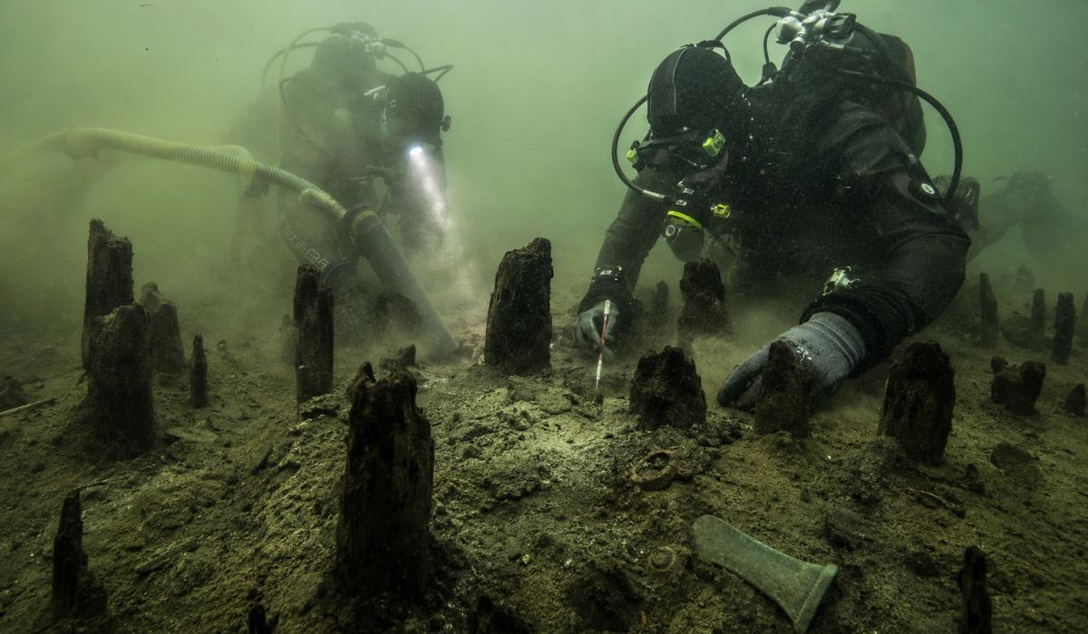
An entire village lay asleep at the bottom of a lake for 3,000 years: divers suction sediments in Italy and reveal more than 600 wooden stakes, bronze tools, and traces of a Bronze Age settlement hidden underwater.
-
They call it the “Shopee house” and even cardboard, but the R$ 20,000 house is a certified Wood Frame from Alea, financed by Minha Casa Minha Vida: understand if it’s worth more than masonry.


Cold front changes weather on the São Paulo coast
While the first half of the holiday maintains typical characteristics of warm days, Friday, May 1, and Saturday, May 2, are expected to register high temperatures, with **maximums ranging between 26°C and 32°C** in different points of the coastal strip.
The change begins to take shape with the advance of a cold front over the South and Southeast, driven by an extratropical cyclone offshore, while a cold air mass advances in the rear and intensifies the thermal contrast.
Gradually, cloudiness increases over the São Paulo coast, winds begin to blow from other directions, and high humidity creates favorable conditions for the formation of instability areas, making the transition noticeable from Saturday night.
Sunday concentrates higher risk of storms
On Sunday, May 3, the scenario changes more forcefully, being considered the period of greatest attention for the entire coastal strip, especially due to the intensification of atmospheric instabilities forecast for the day.
According to Climatempo, there is a possibility of **heavy rain with accumulations exceeding 60 mm in a few hours**, a condition that increases the risk of flooding, flash floods, and other disruptions in urban areas and more vulnerable regions.
In hillside areas, riverbanks, or neighborhoods with a history of flooding, monitoring should be constant, as saturated soil and concentrated rainfall increase the likelihood of occurrences associated with excess water.
Furthermore, the combination of atmospheric instability favors the occurrence of **lightning and wind gusts**, which requires extra caution on beaches, marinas, and open areas, where exposure during storms poses a greater risk.
Rough seas and risk of heavy swell on the coast
Parallel to the weather changes, sea behavior also tends to alter throughout the weekend, influenced by the low-pressure system acting over the ocean, which intensifies sea agitation.
Under these conditions, there is a **risk of heavy swell and difficulty for navigation**, especially for small vessels, in addition to greater danger for bathers in areas with strong waves and more intense currents.
In stretches of the coastline considered more vulnerable, the advance of waves can occur during periods of high tide, amplifying impacts on coastal structures and requiring extra caution from those frequenting these areas.
Temperature drop surprises after heat
After two days of more intense heat, the arrival of cold air causes a significant change in the thermal pattern of the São Paulo coast, especially from Sunday, when the perceived temperature already begins to drop more noticeably.
In this context, maximums should be close to **23°C, representing a drop of up to 10°C compared to previous days**, a difference that becomes even more evident due to the presence of humid wind and reduced sun exposure.
The thermal sensation tends to be even lower, which requires preparation from those traveling to the beach, as the contrast between the days can surprise those expecting to maintain the same climatic pattern as the beginning of the holiday.
On Monday, May 4, although the cold front begins to gradually move away, the polar air mass still acts over the region, keeping the weather cooler and preventing the immediate return of higher temperatures.
Highways require attention on holiday return
With the change in weather conditions, the return from the coast may occur under intense rain, wet roads, and reduced visibility, factors that increase the risk of accidents, especially on mountain stretches.
Drivers using the Anchieta-Imigrantes System, the Rio-Santos highway, and other roads in the region should maintain constant attention, considering the possibility of fog, strong winds, and water accumulation on the road.
Given these conditions, it is essential to follow updates from authorities, respect signage, and avoid travel during periods of heaviest rainfall, reducing exposure to risk situations.
Furthermore, announcements from the Civil Defense and meteorological services should be observed frequently, especially in unstable scenarios, when rapid changes can occur within a few hours.
In situations of intense rain, the guidance remains focused on prevention, avoiding flooded areas, not crossing flash floods, and seeking safe places until conditions improve.


Be the first to react!