
 Portuguese
  Spanish
Road Created to Integrate the Country Crosses Sensitive Biomes, Faces Permanent Technical and Environmental Challenges, and Remains Incomplete After Decades of Punctual Works, Budget Disputes, and Changes in Priority, Maintaining Direct Impact on Logistics, Mobility, and the Life of Isolated Communities.
The BR-230 (Transamazon Highway) was planned to connect the Northeast coast to the interior of the Amazon.
As of 2025, it remains one of the most well-known federal highways in Brazil precisely for being incomplete at crucial points.
The official route goes from Cabedelo (PB) to Lábrea (AM).
-
Driver who “holds” the left lane can receive a hefty fine and 4 points on their driver’s license even if they think they are going at the correct speed for the road.

-
São Paulo Government puts R$ 343 million on the table and releases 31 km of duplication, 9.84 km of third lanes, 4 reinforced viaducts, and 8 grade-separated returns.

-
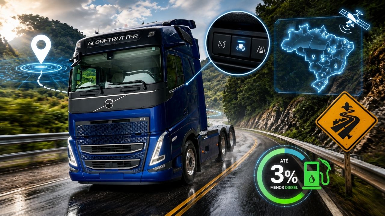
Volvo FH 2026 truck automatically reduces speed in risk areas in Brazil with GPS, activates engine brake without driver intervention, and combines safety with aerodynamics capable of saving up to 3% of diesel in some operations.

-
A viaduct over 40 years old in a city in Minas Gerais was closed due to the risk of collapse, blocked routes for months, exposed maintenance failures, and now requires a R$ 1.7 million project to prevent a collapse in the urban heart for decades.


It spans approximately 4,260 kilometers, with long paved segments interspersed with stretches still in their natural bed or with primary coating.
This type of surface significantly deteriorates during the rainy season.
Conceived and started during the military dictatorship, the Transamazon Highway was presented as a axis of national occupation and integration.
The project was part of the National Integration Program (PIN).
The proposal combined a discourse of territorial integration with colonization policies along the road corridor.
This planning occurred during a period when the federal government defined areas considered priorities around the highway.
Route of the BR-230 and States Crossed

In practice, the BR-230 functions as an east-west backbone.
The highway starts on the Paraíba coast, crosses semi-arid areas, and advances toward the Legal Amazon.
Along the way, the route frequently crosses Paraíba, Ceará, Piauí, Maranhão, Pará, and Amazonas.
Therefore, even when traffic is low in certain segments, the road remains the primary land connection for isolated cities.
These municipalities depend on the road for regular supplies and access to public services far from large centers.
In areas of Pará, for example, the highway is a part of the daily lives of cities like Marabá, Altamira, and Itaituba.
These municipalities connect, via BR-230, to other federal highways and regional production chains.
Still, the standard is not uniform along its entire length.
There are segments with adequate asphalt and signage.
Others remain under construction.
In various parts, the dust of the dry season gives way to mud when the rains intensify.
Why the Transamazon Highway Has Never Been Fully Paved
The explanations for incomplete paving involve engineering, public budgeting, and environmental licensing.
In Amazonian areas, the volume of rainfall and soil behavior raise implementation costs.
The impact is even greater during the maintenance phase.
When the subgrade becomes waterlogged, it loses structural resistance.
This requires permanent drainage, a greater number of culverts, and constant reinforcement of the road base.
These solutions increase the cost per kilometer compared to highways built on more stable terrains.

Another relevant factor is the territorial context.
The BR-230 crosses or approaches environmentally sensitive areas.
It also passes through regions with traditional communities and indigenous peoples.
This scenario increases the demand for studies and conditions for the release of works.
The processes tend to be lengthy.
They may suffer judicial challenges.
They frequently result in revisions of routes or construction methods.
All of this directly affects the pace of execution.
Moreover, the demand profile influences investment decisions.
In certain segments, the vehicle flow is lower than in consolidated logistics corridors in the country.
Historically, this has reduced the budget priority of the Transamazon Highway compared to other federal highways.
Even when there are forecasts for works, continuity depends on annual budgets and successive government decisions.
Rains, Clay Soil, and the Challenge of Keeping the Road Passable
In the Amazon, the problem is not limited to building the highway.
Keeping the road minimally passable is a permanent challenge.
In sections without definitive pavement, the rainy season opens craters and causes embankment collapses.
In critical points, passage may be interrupted for days or weeks.
The response usually involves constant patrolling, material replenishment, and emergency drainage improvements.
These interventions aim to ensure minimal circulation.
Bringing machines, fuel, and teams to remote areas also increases costs.
In some places, access depends on ferries or precarious secondary roads.
This fragile logistics compromises schedules and increases costs.
The result is a highway marked by cycles of deterioration and partial recovery.
Punctual Works and Historical Bottlenecks of the Transamazon Highway
Despite the limitations, the BR-230 continues to receive localized interventions.
The works usually focus on bottlenecks that interrupt regional flow.
An example is the bridge over the Xingu River, in Pará.
The structure was announced by DNIT as part of an effort to replace ferry crossings.
The change directly affects the connection between municipalities in the region.
Such projects have an immediate impact on local mobility.
However, they do not resolve the heterogeneity of the corridor as a whole.
The Transamazon Highway continues to be marked by islands of continuous paving.
In other points, the trip remains conditioned by weather, bed preservation, and the level of nearby rivers and igarapés.
Importance of the BR-230 for Cities, Economy, and State Presence
Even without complete paving, the BR-230 maintains a central role in regional integration.
In the paved sections, the highway facilitates the flow of agricultural and extractive production.
It also reduces access time to consumption centers and services.
In sections still without definitive pavement, the road serves as a basic supply axis.
For thousands of residents, it is the main route to schools, hospitals, markets, and public agencies.
The history of the Transamazon Highway is intertwined with the formation of urban centers along its route.
This process is associated with the occupation policies implemented during the PIN.
The topic remains present in studies about the territorial integration strategy adopted during that period.
Today, the debate about the future of the BR-230 revolves around two central points.
On one hand, the need to improve infrastructure where the road is vital for the local population.
On the other, the obligation to comply with stricter environmental and social standards than those in place when the project was launched.
In this context, the discussion tends to focus on priority segments, special artworks, and engineering solutions that reduce disruptions.
How to reconcile the demand for mobility and development with environmental preservation and budget realities on a highway traversing some of the country’s most sensitive areas?


Be the first to react!