Portuguese
  Spanish
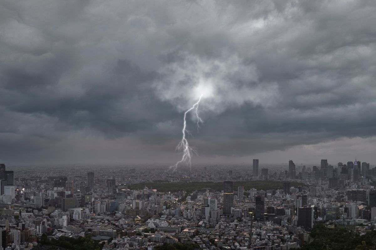
After Days Of Heat, Santa Catarina Sees Highs Near 37°C In The West And 35°C In The Rest Of The State, But Starting Thursday There Is A Forecast For Storms. Civil Defense Points To A Moderate To High Risk Of Flooding, Flash Floods, And Roof Blow-Offs, Especially In The Itajai Valley, Greater Florianopolis, And North.
Santa Catarina Enters A Sequence Of Days Of Strong Heat, With Thermometers Reaching 37°C In Some Regions, While Civil Defense Reinforces The Alert For A Change In Weather With Storms That Should Spread Throughout The State.
The Change Happens Amid Moderate To High Risk For Flooding, Isolated Flash Floods, And Roof Blow-Offs, Mainly In The Itajai Valley, Greater Florianopolis, And In Northern Santa Catarina, With Instability Advancing Towards The Weekend And Making The Sea More Agitated On The Coast.
Heat Dominates The Next Days In Santa Catarina
The Forecast Points To A Scenario Of High Temperatures In Santa Catarina, Highlighting The Period Between Tuesday (27) And Wednesday (28). In This Interval, The Highs Approach 37°C In The West And Reach Near 35°C In The Rest Of The State, Maintaining The Feeling Of Stifling Heat In Various Regions.
-
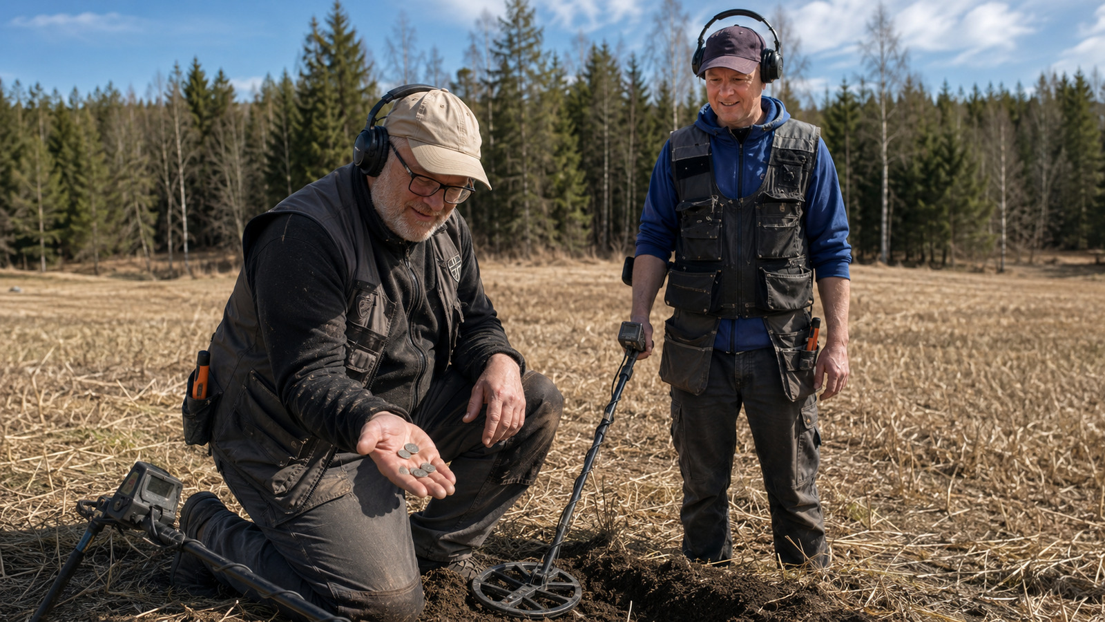
Metal Detector Enthusiasts Uncover Largest Viking Coin Hoard in Norwegian History with 2,970 Silver Pieces Near Rena

-
5 km Lunar Pipeline Could Supply Oxygen to Astronaut Bases, Replace Transport Robots, and Become First Major Infrastructure Project Beyond Earth

-
U.S. Attempted to Tame Hurricanes with Silver Iodide and Aircraft for Nearly 20 Years
-
Teen Inventors Win $50,000 for Pen-Sized Device Using Ultrasound to Remove 94% of Microplastics from Water


In Addition To The Highs, The Lows Also Vary Considerably According To The Terrain. In The Mountains, Thermometers Range Between 10°C And 14°C, While In The Other Regions The Lows Oscillate Between 16°C And 21°C. This Contrast Helps Reinforce The Perception Of Heat Throughout The Day, Especially Where The Afternoon Heats Up And The Night Does Not Cool Off Much.
Civil Defense Warns Of Storms, Flash Floods, And Roof Blow-Offs
With The Heat, The Weather Changes And The Trend Is For Storms In Santa Catarina Starting Thursday (29).
The State Secretariat For Protection And Civil Defense (SDC) Indicates Moderate To High Risk Alert For Events Associated With Instability.
The Alert Highlights Three Main Impacts: Flooding, Isolated Flash Floods, And Roof Blow-Offs.
Attention Increases Especially In Areas Where The Combination Of Intense Rain In A Short Period And Gusts Can Generate Quick Disruptions, Such As Flooded Streets, Water Flowing Rapidly, And Damage To Roofing And More Vulnerable Structures.
Where The Risk Increases: Itajai Valley, Greater Florianopolis, And North
Among The Regions Cited As More Sensitive To The Scenario Of Storms, The Alert Emphasizes The Itajai Valley, Greater Florianopolis, And Northern Santa Catarina.
In These Areas, The Risk Of Stronger Episodes Is Highlighted As Greater, Precisely Due To The Historical Quick Response To Events Of Intense Rain And The Possibility Of Wind Associated With The Storms.
The Practical Message Is Direct: Even If The Rain Does Not Fall With The Same Intensity Across The Territory At The Same Time, The Storms Can Hit Specific Points With Enough Force To Cause Localized Flash Floods And Roof Blow-Offs, Requiring Extra Attention In Low Neighborhoods, Slopes, And Places That Already Accumulate Water Easily.
Timeline Of The Weather Change Until The Weekend
The Period Of Greatest Heat Concentrates Until Wednesday (28), And Starting Thursday (29) The Pattern Changes With The Entry Of Storms In Santa Catarina.
The Instability Continues Until Friday (29), With Storms Described As Less Intense Than The Day Before, But Still Present.
Over The Weekend, The Weather Remains Unstable, With An Emphasis On The Santa Catarina Coast.
Even When Storms Appear More Irregularly, The Situation Continues To Require Caution, As Showers And Storms Can Occur In An Isolated Manner.
South Wind And Agitated Sea On The Santa Catarina Coast
In Addition To The Showers, The Weekend Draws Attention Due To The Agitated Sea On The Coast, Associated With The Increase Of The South Wind.
This Type Of Situation Quickly Alters The Conditions Of The Sea, Bringing Stronger Waves And A More Unstable Environment For Coastal Areas.
The Text Also Mentions A Low-Pressure Center In The Ocean Favoring Showers And Well-Isolated Storms On The Coast.
This Reinforces The Pattern Of Pointed Instability, Where It Does Not Always Rain In All Cities At The Same Time, But Where It Rains May Be Enough To Generate Disruptions.
With This Scenario Of Heat Followed By Storms In Santa Catarina, Have You Already Felt This Sudden Change In Weather In Your City Or Are You Still Just Feeling Stifled?