 Portuguese
  English
  Spanish
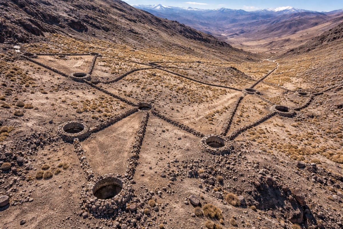
The University of Exeter archaeologist located 76 chacus on the Camarones River in northern Chile to reveal an ancient network of capture, mobility, and human occupation at altitude
A large-scale discovery in northern Chile has unveiled an ancient system that remained hidden for centuries in the Andean landscape. In the region of Arica and Parinacota, a set of 76 chacus was identified in the Camarones River basin and has drawn attention for its size, technique, and historical impact.
The find shows that human groups organized monumental structures in extreme altitude areas to efficiently conduct collective captures. More than an archaeological curiosity, this set helps recount how ancient communities lived, circulated, and secured resources in a challenging territory.
The revelation also changes the perception of occupation in the Chilean altiplano. Instead of a rare or transient presence, what emerges is a scenario of permanence, adaptation, and planning over many centuries.
-
The Government has already released the new RG for 52 million Brazilians with a single CPF, integrated biometrics, a digital version on Gov.br, and national validity.

-
Mr. Jayr, at 78 years old, lives high up in the Serra do Condado, where he was born with 13 siblings. He produces milk, makes award-winning artisanal cheeses, and preserves a family tradition marked by hard work, faith, and love for the land.
-
Luciano Hang claims persecution after Havan was notified for using the Brazilian flag on shopping bags.

-
Ypê gets a stay and can resume manufacturing suspicious items, but Anvisa maintains the alert, advises consumers not to use the products, and competitors advance.


Stone walls 1.5 meters high and up to 150 meters created a capture funnel
The chacus were V-shaped and built with dry stone walls positioned to function as a corridor. The structure directed moving groups to a circular enclosure at the endpoint, where escape became much more difficult.
On average, the walls reached 1.5 meters in height and about 150 meters in length. At the final stage of the route, the system ended in a fenced space with wells approximately 2 meters deep, which reinforced the retention effect.
The engineering is impressive because it did not rely solely on the construction itself. The design took advantage of the terrain, slopes, and natural circulation in open areas. Thus, the entire landscape was transformed into a tool for collective capture, with a logic that is both simple and sophisticated.

Area of 4,600 km² revealed almost 800 small settlements linked to the system
The investigation covered about 4,600 km² in the Camarones basin and focused the analysis on high areas of the mountain range. The use of satellite images allowed mapping not only the traps but also a wide distribution of traces of human presence associated with this mode of occupation.
Next to the main structures, about 800 small settlements appeared scattered throughout the territory. These points suggest temporary permanences, planned displacements, and continuous use of strategic areas for supply and circulation.
This scenario expands the scope of the discovery. These are not isolated structures in a remote environment. What is emerging is an organized network, with support points, areas of recurring use, and connections between different zones of the high plateau.
The reading of the territory changes scale when the traps are observed alongside these settlements. The space begins to be understood as an active landscape, shaped by human groups who knew exactly where to stay, when to move, and how to use the environment to their advantage.
Practice began in 6000 BC and advanced until the 18th century
The chronology associated with the chacus helps explain why the find gained international prominence. The evidence points to practices that begin at least in 6000 BC and continue until the 18th century, showing a much greater continuity than previously estimated for high-altitude areas.
This alters a traditional view of northern Chile. Instead of imagining an early abandonment of the most hostile zones, the discovery suggests a persistent occupation, with human groups maintaining their own survival strategies even amid social and economic transformations.
According to Antiquity, an international academic journal specializing in archaeology, the concentration found in Camarones is one of the most expressive ever documented in the Andean context and reinforces the coexistence of gathering, hunting, and agropastoral practices in the same space.
This point is decisive because it shows the overlap of ways of life. The landscape was not used in a single way during a single phase. It supported different experiences over time, with human permanence in an environment that required precise knowledge of the terrain.

Giant structures ensured food, raw materials, and control of the territory
The function of these traps was linked to obtaining essential resources for ancient Andean communities. Collective capture provided access to food, raw materials for clothing, and valuable inputs in a survival context at high altitude.
This helps to understand why the construction was so robust. Erecting long walls, organizing final enclosures, and choosing passage points in elevated areas required collective effort and accumulated knowledge. The return was worth it because the operation allowed for economies of scale.
The importance of these practices is also reflected in local rock art. The representations suggest collective actions and rituals associated with the capture process, indicating that the activity went beyond immediate utility. It was part of the social organization and cultural memory of these communities.
When this symbolic element is combined with the economic dimension, the discovery gains even more strength. The chacus cease to be merely ancient ruins and become concrete evidence of how technique, labor, and culture intertwined in the high plateau.
There were few examples before, and now the number jumps to 76
Until recently, this type of structure was known in very limited numbers in the Andes. With the documentation of 76 traps in a single basin, the scale of the phenomenon changes dramatically and forces researchers to reconsider previous estimates.
There are also signs that new structures may exist further south, which expands the potential for future investigations. Even without turning every indication into a definitive count, the scenario is already sufficient to show that this technology was much more widespread than previously thought.
The comparison with ancient traps from other arid regions of the planet arises naturally due to the funnel shape and the logic of collective guidance. Still, the documented set in Chile has its own characteristics and stands out for its uniqueness in South America.
This difference weighs in the archaeological debate because it shows that large engineering solutions for mass capture were not restricted to other parts of the world. They were also part of Andean history on a scale that is now much more visible.
Sentinel 2 and Google Earth revealed an ancient landscape that had been hidden for centuries

The identification of the chacus was only possible with the support of modern surface observation tools. Images from Sentinel 2 and Google Earth helped locate discreet marks in a vast, dry territory that is difficult to traverse by traditional methods.
This use of technology shows how current archaeology can reinterpret entire landscapes with greater precision. What once seemed like mere natural relief now reveals lines, enclosures, and connections that indicate large-scale human planning.
The result goes beyond visual discovery. The structures confirm that ancient populations developed complex solutions to live at altitude, organize movements, and ensure resources collectively. This reinforces the technical capacity of these groups and amplifies the historical significance of the region.
In the end, the Camarones basin ceases to be just a remote area of the Chilean mountain range and begins to be seen as a territory of high historical density. When 76 giant traps reappear with the help of satellites, the past changes in scale and repositions Latin America.


-

-

-

-

-

-

10 people reacted to this.