
 Portuguese
  Spanish
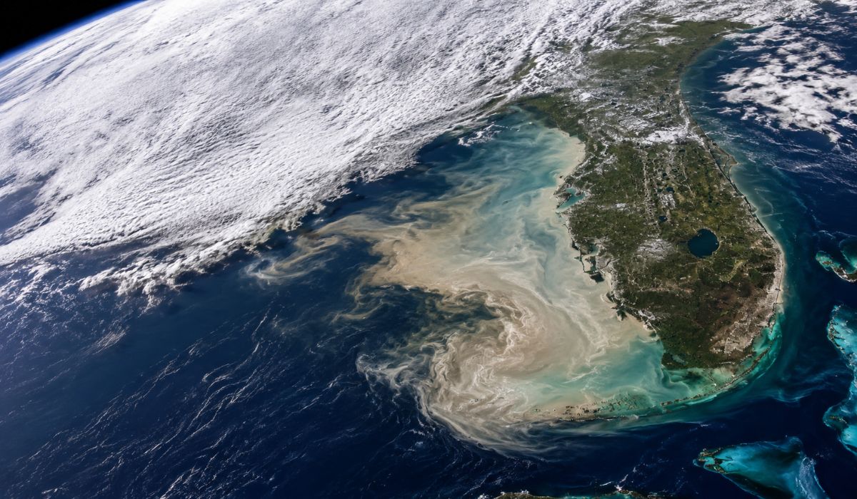
A NASA satellite image shows an unusual change in the Florida sea, linked to the advance of Arctic air and oceanic processes that reveal invisible details from the surface.
An image captured by the Terra satellite from NASA, on February 3, 2026, showed a bluish band of suspended marine sediments over the continental shelf west of Florida, in the Gulf of Mexico.
The record, released by the NASA Earth Observatory, indicates how a wave of Arctic air that hit eastern North America also temporarily altered the appearance of the shallow waters near the Florida Keys.
The phenomenon was not associated by NASA with pollution or algae bloom.
-
Engineers Develop Jacket That Converts Air Humidity Into Drinkable Water, Producing Up to 900 ml Daily for Hikers, Campers, Rescuers, Rural Workers, and Military in Remote Areas

-
NASA Plans to Repurpose Mars Rover for Lunar Mission, Sending a 1-Ton Nuclear-Powered Vehicle to Explore the Moon’s South Pole Without Solar Dependence
-
Early Humans Made Beds Nearly 200,000 Years Ago in African Caves, Study Reveals

-
Japanese Smart Bike Detects Cyclist’s Intent to Turn and Potential Falls


According to the space agency, the light hue appeared mainly due to mud rich in calcium carbonate, stirred up from the seabed by winds and currents linked to the cold front.
The material remained suspended in the water and formed spiral patterns visible in satellite images.
The comparison made by the NASA Earth Observatory shows the difference between January 24, 2026, before the arrival of the cold air, and February 3, 2026, when the water already appeared clearer over the West Florida Shelf, a wide shallow area of the continental shelf.
The region is described by the agency as a “carbonate ramp,” due to the concentration of sediments formed from marine organisms.
Arctic air wave hit Florida and changed the color of the sea
At the end of January and the beginning of February 2026, masses of Arctic air advanced over eastern North America and caused intense cold in parts of the United States.
NASA reports that snow and ice covered extensive areas of the country, with records as far south as Georgia, while Florida counties experienced below-zero temperatures at the beginning of February.
The meteorological explanation involves the dynamics of the polar vortex, a term used by the United States National Weather Service to describe a large area of low pressure and cold air around the poles.
This system exists permanently in polar regions but can expand during winter and favor the displacement of cold air to lower latitudes, with the influence of the jet stream.
In this context, the same atmospheric pattern that brought freezing air to cities and roads also produced effects on the ocean.
Upon reaching Florida, the cold air helped cool shallow waters over the continental shelf.
With strong surface winds, the seabed was stirred up, and fine particles accumulated on the ocean floor rose to more visible layers.
Calcium carbonate explains the light-blue plume in the Gulf of Mexico
Calcium carbonate is a common compound in rocks like limestone, but in this case, NASA attributes the origin of the material to biological processes.
The suspended mud seen in the image is mainly formed by remnants of corals, algae, shells, and other organisms living on the continental shelf.
When these beings die, their carbonate-rich structures settle on the seabed over time.
Being shallow and extensive, the West Florida Shelf accumulates this type of sediment in large quantities.
Under normal conditions, much of this material remains at the bottom.
During wind and cooling events, however, the particles can be stirred up and suspended in the water column, changing the way sunlight is reflected.
James Acker, a data support scientist at the NASA Goddard Earth Sciences Data and Information Services Center, explained to the Earth Observatory that the mud was lifted mainly by the wind-stirred waters during the cold air event.
According to him, the cooling of the shallow water increases its density compared to the open ocean water around it.
With this increase in density, the water can sink and move off the shelf with the tidal movement.
In this process, part of the sediments is carried towards the edge of the continental shelf.
The combination of these factors helps explain why the plume appears in stripes, curves, and swirls, rather than as a uniform stain.
Satellite images reveal swirls near the Florida Keys
The most concentrated part of the plume appears north of the Florida Keys, with emphasis on the region near Key West and Dry Tortugas National Park.
Images taken by Landsat 9, also analyzed by NASA, show smaller structures within the bluish band, including shapes known as “hammerhead eddies.”
These eddies can occur when narrow streams of cold, dense water, loaded with sediment, meet slower waters of the Gulf of Mexico.
According to NASA’s explanation, this encounter creates pairs of vortices that rotate in opposite directions, producing two curves connected to the same current.
Further southwest, near Dry Tortugas, the agency points out another dynamic.
The sediment-laden water exited the platform through south-facing channels and was quickly carried eastward by the Loop Current, an ocean current in the Gulf of Mexico.
This type of interaction was also observed after Hurricane Ian, which hit Florida in 2022 and stirred up sediments in the region.
The difference, according to the analysis presented by the Earth Observatory, lies in the type of disturbance.
Hurricanes tend to stir the seabed with greater intensity.
Cold fronts, on the other hand, can suspend sediments through the combination of wind, water cooling, and circulation over shallow platforms.
Marine plume helps scientists study sediments in the ocean
Besides the visual record, the image is used by scientists to observe how carbonate sediments move in shallow marine environments.
This process is part of studies on the circulation of carbon-rich particles in the ocean, although the specific contribution of cold fronts is still less documented than that of tropical cyclones.
NASA reports that researchers monitor this type of event because it helps indicate when and how materials accumulated on the seabed can be displaced to other areas.
In the case of tropical cyclones, studies cited by the agency point to these systems as relevant mechanisms for transporting carbon from shallow sediments to deeper waters.
Cold fronts, according to the Earth Observatory’s description, seem to act on a more local scale.
In these cases, the change in ocean color can be evident in satellite images, even without the same transport of material to deep areas observed after more intense tropical storms.
The case also shows the usefulness of satellites for monitoring rapid changes in oceanic areas that are difficult to observe directly.
Within a few days, orbital sensors recorded the change in water color, the advance of the plume, and the formation of eddies associated with ocean circulation.
For research, this type of image gathers information about wind, temperature, water density, sediments, and marine currents.
For the public, the record allows observing how an atmospheric event occurring over the continent can leave temporary marks on the ocean, hundreds of kilometers from the areas most affected by the cold.


