
 Portuguese
  Spanish
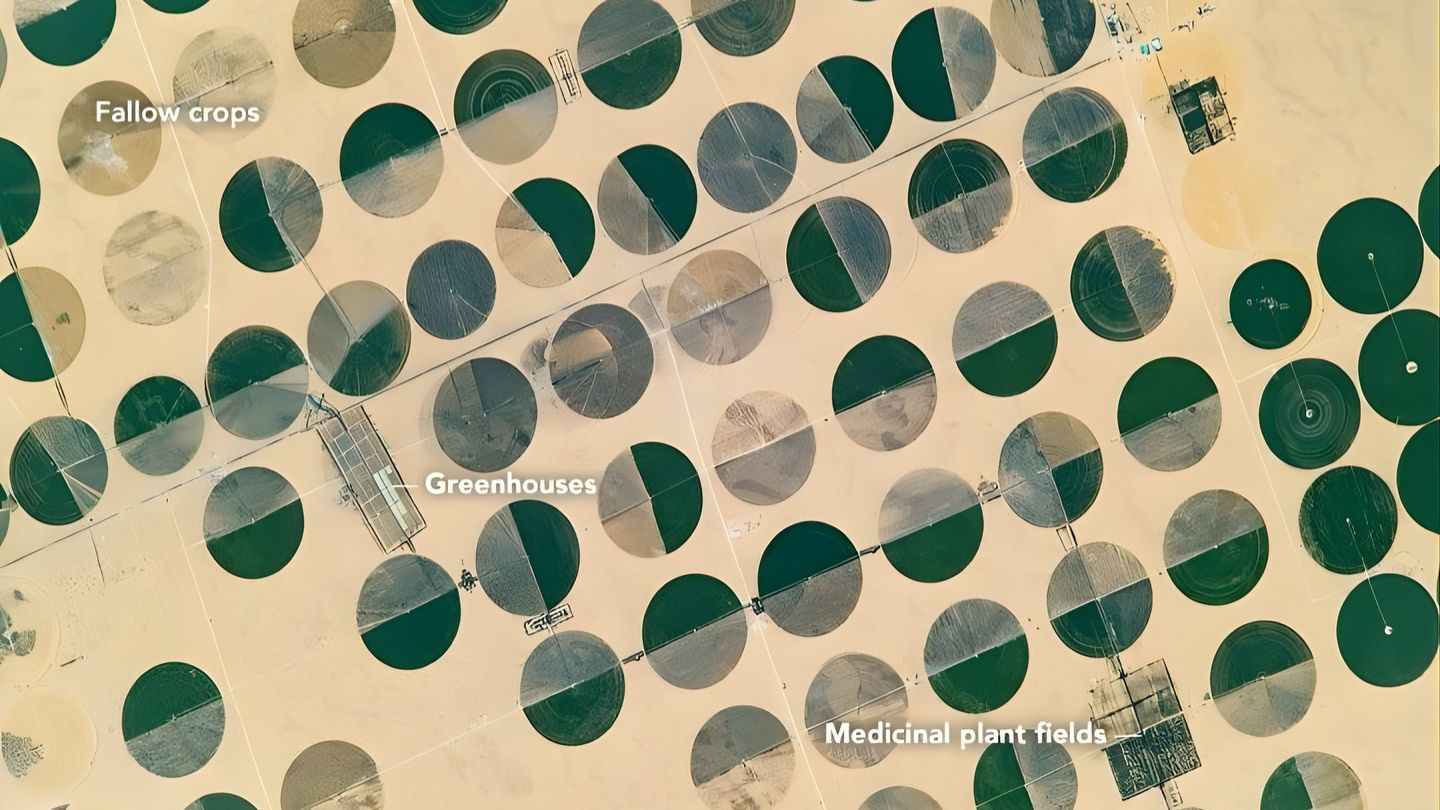
Satellite images reveal green circles in the Sudan desert and show how groundwater aquifers sustain agriculture in arid regions.
In satellite records analyzed over the 2000s and 2010s and widely publicized by the NASA Earth Observatory and later in images of Sharq El Owainat, the Sahara began to reveal a phenomenon that, at first glance, seems too artificial to be real: almost perfect green circles appearing in the desert strip near the border between Egypt and Sudan and in the southwest of Egypt, in one of the most arid regions on the planet.
These formations, visible from space with impressive clarity, can reach about 1 kilometer in diameter and create an extreme contrast with the surrounding environment, dominated by sand, rocks, and almost no precipitation. The repetitive geometric pattern is not the result of a natural process: according to the NASA Earth Observatory itself, it is a center pivot irrigation system, where water is pumped from wells at the center of each cultivated area and distributed by long rotating arms.
What these images reveal is a technology capable of transforming areas considered practically inhospitable into productive zones, sustaining crops in the desert with water engineering, energy, and extraction of groundwater from the Nubian Sandstone Aquifer System. In practical terms, it is this technical arrangement that allows for large-scale agriculture in sections of the Sahara where, without artificial irrigation, production simply would not be sustainable.
-
Low-Demand Brazilian Beef Offal Gains Popularity Abroad: Indonesia Purchases $19.5 Million, Boosting Revenue and Reducing Waste

-
Soy Expansion in Former Brazilian Savanna Sparks Water and Land Conflicts in Major Agricultural Frontier
-
Mexican Pest Threatens U.S. Cattle Herds at Historic Lows, Potentially Boosting Brazilian Beef Exports as Burger Prices Soar

-
Avocado Boom for European and U.S. Markets Fuels Water Crisis in Drought-Stricken Chilean Region


What are the green circles and how do they form
The circles observed in satellite images are the result of the use of center pivot irrigation, an agricultural method that consists of rotating equipment installed around a fixed point. This equipment distributes water evenly while rotating, creating circular-shaped crops.
The system operates from a long metal arm, which can reach hundreds of meters, equipped with sprinklers that release water along its length. As the equipment rotates around a central axis, it irrigates the entire surrounding area, forming an almost perfect circle when viewed from above.

This type of irrigation is especially efficient in flat and open regions, such as the Sudanese desert, where there are no significant natural obstacles.
The visual result is impressive: green and dense agricultural areas surrounded by a completely arid environment, creating patterns that appear to be drawn with geometric precision over the landscape.
Groundwater aquifers sustain agriculture in the desert
The most critical element for the functioning of these systems is not on the surface, but below it. The water used for irrigation does not come from rivers or frequent rains, but rather from deep groundwater aquifers, many of which are classified as fossil aquifers.
These reservoirs were formed over thousands or even millions of years, during periods when the climate of the region was much more humid than it is today. In the case of North Africa, these aquifers store water accumulated during ancient phases of the Sahara, when the region had lakes, vegetation, and a climate more favorable to life.
By drilling into the ground at depths that can exceed hundreds of meters, it is possible to access these reserves and pump water to the surface. This water then feeds the center pivot systems, allowing for continuous irrigation of the crops. This process is what makes the existence of these green circles in the desert possible.
Technical dimensions and scale of agricultural operations
Each circle visible in satellite images can reach between 500 meters and 1 kilometer in diameter, depending on the size of the installed system. This means that a single unit can irrigate dozens of hectares of land.
When multiple systems are installed close to each other, the result is a mosaic of green circles that spreads across large stretches of the desert. These areas are used for growing crops such as:
- Wheat
- Corn
- Alfalfa
- Forage for livestock
The scale of these operations can be significant, with agricultural projects occupying hundreds or even thousands of hectares in previously considered unproductive regions.
Extreme visual contrast captivates NASA and researchers
The images captured by satellites and analyzed by institutions such as NASA draw attention not only for the functionality of the systems but for the visual impact they produce.
From an orbital perspective, the green circles stand out intensely against the sandy background of the desert. This contrast is so striking that these areas have become frequent examples in studies on land use and landscape transformation by human activity.
Furthermore, these geometric patterns help researchers quickly identify areas of intensive agriculture in arid regions, facilitating the monitoring of water resources and land use.
Limitations and risks of using fossil aquifers
Despite the technical success of these systems, there is a critical point that has been debated by experts: the sustainability of using fossil aquifers.
Unlike renewable sources, such as rivers and rains, these aquifers are not replenished on a significant scale in the current climate of the Sahara. This means that the water extracted is, in practice, a finite resource.
The intensive use of these reservoirs can lead to a progressive reduction in water levels, increasing the cost of extraction and eventually making the continuation of agricultural operations unfeasible.
This phenomenon has already been observed in other regions of the world where fossil aquifers are exploited on a large scale.
Agriculture in the desert redefines the limits of global production
Even with the limitations, center pivot irrigation systems in the desert represent a significant transformation in how agriculture can be practiced in extreme environments.
They demonstrate that, with access to underground resources and appropriate technology, it is possible to convert arid areas into productive zones.
This model has been replicated in different parts of the world, including regions of Saudi Arabia, Libya, and the United States, always based on the same logic: intensive use of groundwater combined with mechanized irrigation systems.
The green circles in the Sudan desert show how far engineering and technology can go to overcome natural limitations, but they also raise important questions about sustainability and the use of finite resources.
In your view, does this type of agriculture represent a viable solution for the future or a model that could quickly deplete the natural resources that sustain it?


Be the first to react!