
 Portuguese
  Spanish
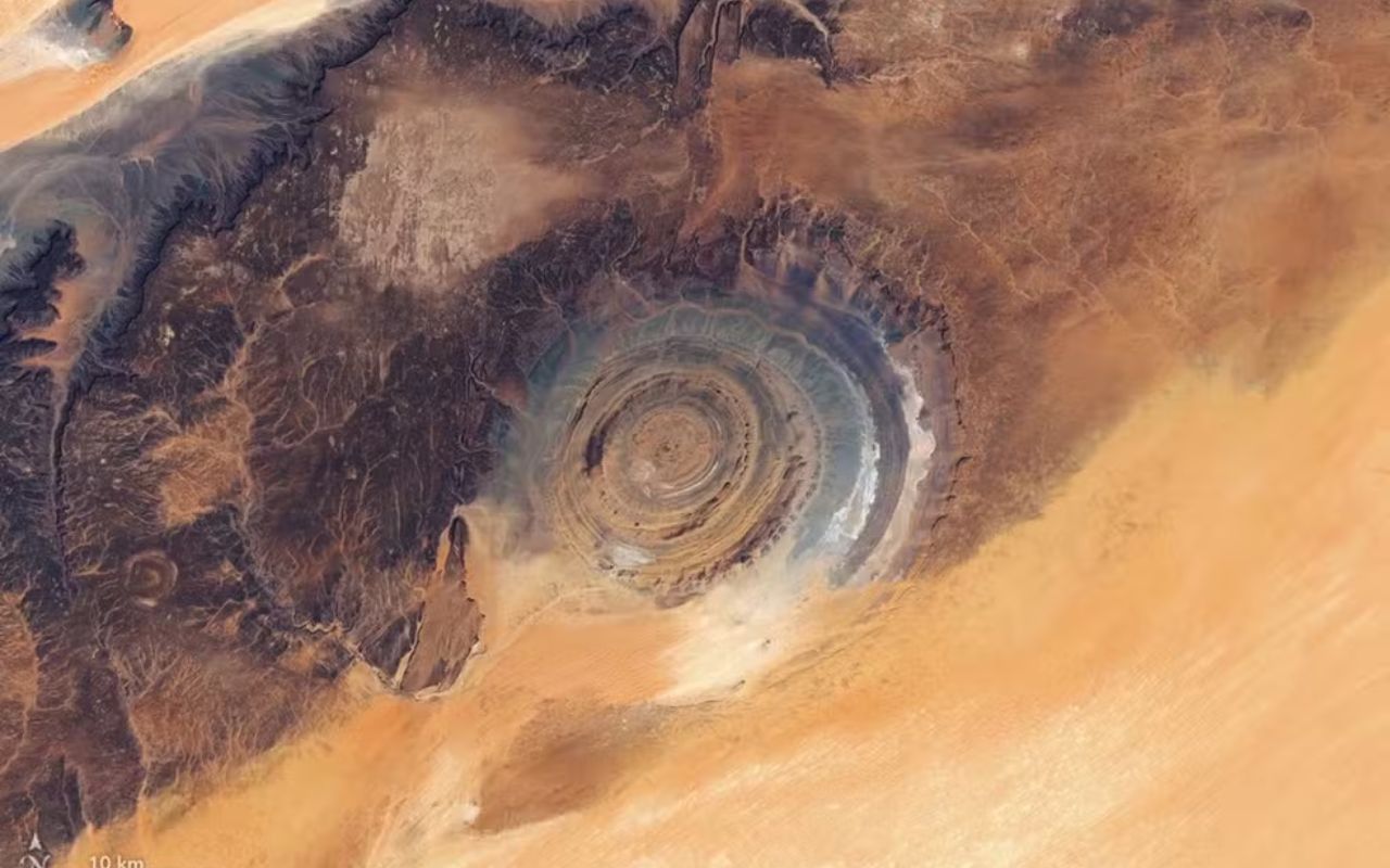
New NASA image shows the Richat Structure (Eye of the Sahara) from space with impressive details. Understand its origin and importance.
Released last Thursday (16), a new NASA image once again highlights the impressive Richat Structure, a formation located in the Sahara Desert, in Mauritania. The record, produced with data collected in March 2026 by the Landsat 8 and Landsat 9 satellites, showcases geological patterns that can only be fully perceived when analyzed from space.
Image from space highlights the “Eye of the Sahara”
In the midst of the vast arid landscape, the Richat Structure draws attention for its unusual circular shape. With about 40 kilometers in diameter, the formation has become known as the “Eye of the Sahara,” precisely because it resembles a giant iris when viewed from a high altitude.
The most recent image reveals well-defined circular bands, with variations in colors between orange and gray tones. These visual differences reflect the diversity of rocks present both in the structure and its surroundings.
-
World Cup Ball Chip Uses Technology to Detect Invisible Touches, Confirms Offside, Secures Portugal’s Victory Over Croatia

-
36-Meter Hydrogen-Powered Superyacht Arrives in Brazil to Debut German Engines and Showcase Future of Clean Navigation

-
Indian Students from Jaipur Win Top Prize at World’s Largest Science Fair with EcoFog, an Affordable Mesh to Harvest Fog Water Without Energy

-
Italy Sinks Massive 11-Story Concrete Structures in the Ligurian Sea to Create a 6.2 km Barrier, Clearing the Way for 400-Meter Ships in Genoa


How did the Richat Structure form?
For a long time, the circular shape led researchers to consider the hypothesis of a meteorite impact. However, more recent studies have shown that the explanation is different.
The formation is the result of a gradual geological process, which can be summarized as follows:
- Rocks were pushed up by underground volcanic activity;
- Over millions of years, erosion acted unevenly;
- This wear created the concentric rings visible today
This set of factors ultimately created the visible rings today, making the Richat Structure a unique phenomenon in the Sahara Desert.
A historic discovery that came from the sky
The formation has been known since the 1930s when French geographers described it and compared it to a “cufflink,” in reference to its circular shape.
Even so, it was only with space exploration that its true dimensions became evident. Decades after this first description, astronauts Ed White and James McDivitt captured images of the site during the Gemini IV mission, increasing scientific interest in the area.

In addition to its geological value, the surroundings of the Richat Structure also reveal important signs of human presence over time. The Adrar plateau concentrates traces that help tell part of this story.
Among the main records found are:
- Tools used by prehistoric populations
- Preserved rock paintings
- Remains of medieval cities linked to caravan routes
This combination makes the region a point where human past and natural transformations intersect.
NASA reinforces the importance of space observation
Observing the Richat Structure from the ground does not allow for an understanding of its complete shape. It is precisely the enlarged perspective, provided by satellite images, that reveals the circular organization of the formation.
For NASA, this type of record demonstrates how certain landscapes can only be correctly interpreted when analyzed on a global scale. In the case of the Sahara Desert, space technology helps expose a structure that, although on the Earth’s surface, remains practically invisible in its entirety to those on the ground.
Thus, the new image reinforces the ongoing fascination with the so-called “Eye of the Sahara,” one of the most striking examples of how observation from space transforms understanding of the planet itself.
With information from g1


Dude, that looks like a flying saucer!!
It is intriguing knowing that there are tools found in it’s surroundings. The historic speculation about Atlantis also focus about the possibility of the eye of the Sahara to be the lost city. There are archaeologists and non scientists claiming a lost Western African civilization, that preceded the Egyptian and actually influenced them. If NASA tries to give geological explanations for such a structure similar to the descriptions of Atlantis, the intention might be to distract tourists and enthusiasts aswell local governments, to let it untouched. Maybe there is some truth that powerful governments might not want us to know. One of them is about cyclic catastrophic events that have wiped previous civilisations.