
 Portuguese
  Spanish
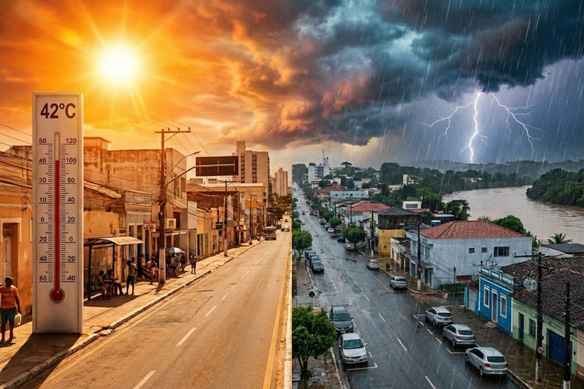
In Brazil, The Combination of Intense Heat and Strong Showers Keeps Saturday (21) Under Attention: Inmet Issues Red Alert for Rain Accumulation in Eight States, with Possibility of More Than 60 mm/h or Over 100 mm/day, Besides Flooding, Overflowing Rivers, and Unstable Slopes in Vulnerable Areas.
In Brazil, Saturday (21) brings together two ingredients that usually increase the potential for disturbances: predominant heat throughout the day and showers that can come strong and concentrated, with areas under maximum alert until the end of the period. The scenario is monitored by meteorological agencies, particularly Inmet and regional analyses indicating rapid weather variation.
In the most critical areas, the concern is not just with the rain itself, but with the chain effect: flooding in urban points, overflowing rivers, and instability of slopes where the soil has already been poorly responding to excess water. The South and Northeast appear as the most sensitive focuses in the accumulation alert, while other regions also enter the radar for storms and elevated volumes.
Maximum Alert and Accumulation: Why the Impact Can Be Quick
When Inmet signals a red alert for accumulation, the central message is that the volume of water can exceed drainage capacity in a short time, especially if the rain falls intensely and locally.
-
Europe unveils armored tank with remote turret, 1,500 horsepower, and 120-millimeter cannon

-
Old hard drives may hide neodymium, dysprosium, praseodymium, and terbium, and a United States company is expanding its network with a new 93,000-square-foot facility to recover rare earths used in electric cars, artificial intelligence, defense, and renewable energy.

-
Giant crane lifts up to 3,000 tons, requires special logistics to reach the site, and can transform 18-hour operations into just 3 hours, speeding up the hoisting of oil platforms, refineries, and plants in giant industrial projects.

-
A discarded microwave may contain 22-carat gold in internal components; study recovered a 450 mg nugget from electronic boards.


In Brazil, this type of situation tends to be more problematic in urban centers with many impervious points and in areas close to rivers, streams, and channels that react with rapid elevation.
The reference to figures like more than 60 mm/h or over 100 mm/day helps to understand “how much” it can rain and why this changes the risk.
Even without constant rain all day long, concentrated showers in a short interval can cause flash floods, invade garages, overload storm drains, and create pools of water in low-lying areas, in addition to increasing the chance of landslides where there are slopes and saturated soil.
South and Northeast in the Spotlight: Where the Risk Concentrates
In Brazil, the maximum alert for accumulation draws attention primarily to the South and Northeast, with indications of elevated risk early on in states such as Maranhão, Paraná, Santa Catarina, Piauí, Tocantins, Bahia, Pernambuco, and Minas Gerais.
It is a broad area, involving urban areas, regions transitioning to the interior, and stretches where rivers and tributaries can respond quickly to increased volume.
Among the highlighted areas as most affected are sections like Sudeste Piauiense, Sudoeste Piauiense, Centro-Norte Piauiense, São Francisco Pernambucano, Centro Norte Baiano, Extremo Oeste Baiano, Vale São-Franciscano da Bahia, Centro Sul Baiano, Leste Maranhense, Norte de Minas, and Oriental do Tocantins.
In municipalities within these sections, the combination of heavy rain, limited drainage, and relief with slopes can make the scenario more delicate, with points of recurring flooding and greater sensitivity to landslides.
Southeast: Heat, Showers at Critical Times, and Attention to Slopes
In Brazil, the Southeast comes into focus, particularly Minas Gerais, especially in the Northern portion, under red alert.
In addition, there is a forecast of heavy to moderate rain in the extreme South of São Paulo and also on the São Paulo coast, where storms may occur at specific times of the day, necessitating attention in areas with a history of flash floods and water pools.
The showers tend to gain strength between late morning and early afternoon in Minas Gerais, Rio de Janeiro, and Espírito Santo, a time that usually coincides with greater warming and moisture availability.
It is in this context that two very practical alert points come into play: urban flooding and landslides, with special attention to the Serrana Region of RJ and the Zona da Mata of MG, where slopes can become unstable with soil saturation.
Central-West: Instabilities Early and Influence of Low Pressure
In Brazil, the Central-West has rain early in the East and Center of Mato Grosso and in the West, East, and interior of Goiás, with a risk of storms mainly in the Northern portion of these states.
This distribution suggests a day of variation, where overcast skies and sunny breaks alternate, and when the rain “fits in,” it can come in heavy showers.
In the West and Southwest of Mato Grosso do Sul, the projection is for light rain with a possibility of intensification in the afternoon, associated with low pressure in Paraguay.
Even when the start of the day seems less threatening, the increase in instability during the warmer period can change the scenario in a short time, and heat remains predominant, keeping the environment suitable for rapidly developing clouds.
North: Storms, Heat, and Double Attention with Rising Rivers
In Brazil, the North Region also registers instabilities early on in Amazonas, Pará, Tocantins, Roraima, and Acre, with a tendency to intensify throughout the day and risk of storms.
In areas where rain tends to be heavy and persistent, the sensitive point becomes the response of watercourses and the condition of roads and bridges in more vulnerable stretches.
Besides the immediate impact on mobility, the accumulation of water throughout the day can increase secondary risks, such as localized overflow, erosion on banks, and heightened flooding points in urban areas.
With heat prevailing, the showers can vary greatly from neighborhood to neighborhood, which demands attention even when the rain seems “distant” visually.
What Changes in Routine and How to Reduce Risks Without Alarm
In Brazil, hot days with strong showers in the environment: where water tends to accumulate, which streets become flood channels, and which routes pass near streams or slopes.
If the region already has a history of flooding, small decisions make a difference, such as avoiding basements and garages during peak instability times, prioritizing movements before the more prone period to storms, and reducing exposure in low-lying areas.
For those living in slope areas, the central point is to observe signs of change in the terrain after heavy rain, such as the appearance of small cracks, soil displacement, and increased runoff in places where there previously weren’t any.
In a maximum alert scenario, the logic is practical: the greater the volume in a short time, the smaller the margin for error in vulnerable points, especially near rivers, channels, and embankments.
In Brazil, this Saturday (21) combines intense heat with heavy rain in showers, and what defines the size of the problem is where and how that volume falls: over 100 mm in a day or more than 60 mm in an hour can turn an ordinary afternoon into a map of disturbances, especially in the South and Northeast, without excluding other regions from the storm radar.
In your city, how does this scenario usually manifest: is the biggest fear flooding on low streets, rivers rising near home, or slopes becoming unstable? And what do you do first when the weather changes quickly, do you change routes, avoid a neighborhood, monitor river levels, or have you already had a scare that became a lesson?


Be the first to react!