Portuguese
  Spanish
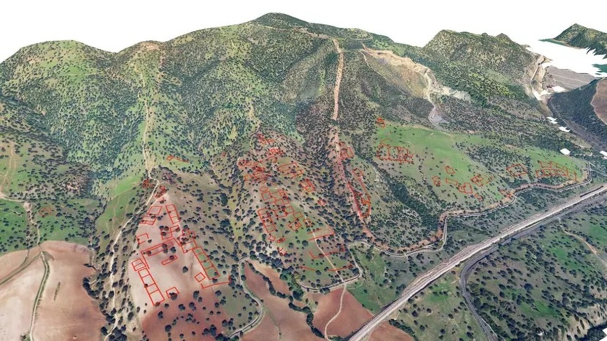
Successive Mappings With LiDAR Technology Identified Anomalies in the Terrain Compatible With a Great Monumental Capital Destroyed in the 11th Century, Rekindling an Archaeological Debate With Over a Thousand Years and Raising the Concrete Possibility of Future Scientific Excavations in Southern Spain
The search for the legendary lost city Madinat al-Zāhira may have advanced after a study indicated its location in the hills of Pendolillas, east of Córdoba, based on LiDAR surveys that identified anomalies compatible with a monumental capital of about 120 hectares.
A Mythical Lost City of Islamic Archaeology
For over a thousand years, the location of Madinat al-Zāhira has been one of the most debated topics in Islamic archaeology. The city is remembered as an architectural wonder that combined Islamic, Roman, and Visigothic styles, featuring luxurious palaces, extensive gardens, and mercury pools designed to make a technological impact.
Built by the Umayyad caliphate of al-Andalus, Madinat al-Zāhira played a central role in the political structure of the empire.
-
15-Year-Old American Builds Ocean Generator with PVC Pipe and 3D-Printed Propeller for $12, Wins National Prize, Presents at White House, and Makes Forbes 30 Under 30 List

-
$12 Billion Invested in AI Data Centers in Semi-Desert Mexican State, But 17 of 18 Municipalities Now Face Water Shortages, Residents Receive Water Only 3 Days a Week
-
How Much Does Starlink Satellite Internet Cost for Cars, Trucks, and RVs? Prices for Antenna, Accessories, and Plans

-
Scientists Convert Food Waste into Aviation Fuel, Successfully Test 50% Blend with Conventional Kerosene to Cut Emissions and Promote Sustainable Flights


Its trajectory was abruptly interrupted in 1010, when it was looted during a civil war, disappearing from the historical map and fueling centuries of academic speculation.
Evidence Raised With LiDAR Technology
A researcher from the University of Córdoba recently presented new evidence suggesting the identification of the site. In an article published in the journal Meridies, Antonio Monterroso Checa described three surveys conducted using LiDAR technology.
The Light Detection and Ranging technique revealed anomalies in the ground that indicate the presence of a large archaeological site.
According to the study, the observed characteristics correspond to what would be expected from the so-called lost city of Almanzor, a central figure of the end of the Spanish Umayyad Empire.
Urban Dimension and Architectural Patterns Detected
The area delineated by the researcher covers approximately 120 hectares, a size considered sufficient to host a monumental capital with political and administrative functions. The irregularities in the terrain suggest buried structures organized in terraces, with rectangular and square architectural designs.
According to a report from the site Ancient Origins, these patterns indicate variations of an orthogonal grid, a characteristic compatible with planned cities.
The layout refers to models already identified in other palatial centers of the period, reinforcing the coherence of the interpretation.
Relation With Madinat al-Zahrā and the Regional Context
The study points to direct parallels with Madinat al-Zahrā, located west of Córdoba and recognized as a World Heritage site by UNESCO in 2018. This comparison supports the hypothesis of continuity of urban models from the caliphate.
The elements detected so far form a set considered coherent with archaeological expectations.
For Checa, the presence of these connections reinforces the possibility that the city remains buried in the analyzed hills, awaiting confirmation through future excavations.
Historical Lineage and Continuous Use of the Territory
The argument was deepened based on the history of occupation of the area. The hills of Pendolillas have remained associated with royal authority over the centuries. In the 15th century, the site was recorded as a dehesa linked to the Royal Domain, according to historical records.
During the reign of Philip II, the area became the official seat for the State horse breeding, known as the Royal Stud, as reported by Arkeonews. This continuity reinforces the symbolic weight of the territory.
Next Steps and Scientific Expectation
The combination of LiDAR data, historical context, and architectural patterns raises the concrete possibility that Madinat al-Zāhira has finally been located.
The hypothesis rekindles the debate about the beginning of systematic excavations at the site, a topic that remains open.
If confirmed, the discovery would represent a significant advance in understanding Umayyad urbanism in al-Andalus.
For now, the gathered evidence indicates that the legendary city may not be lost, just buried, while the scientific community awaits new developments.