Portuguese
  Spanish
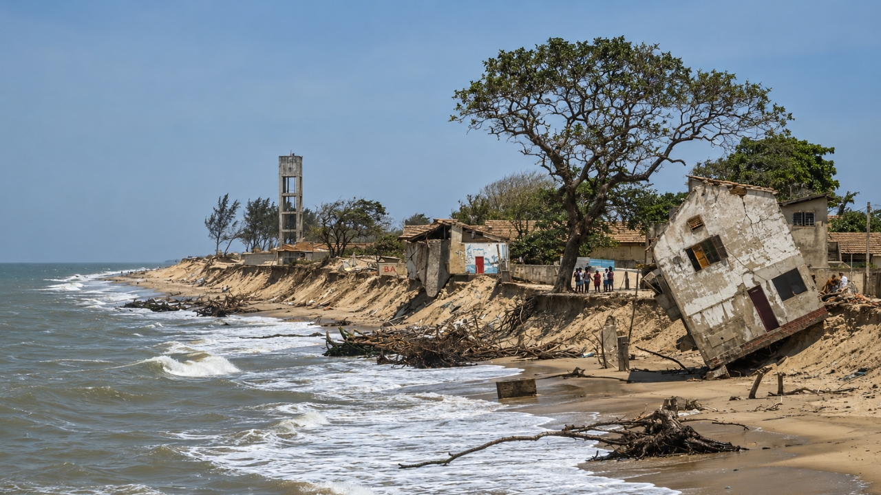
On the coast of Rio de Janeiro, Atafona shows how coastal erosion can transform an urban area into ruins over time, affecting residents, fishing, tourism, and the relationship between the Paraíba do Sul River and the advancing ocean.
In Atafona, a district of São João da Barra in Northern Rio de Janeiro, coastal erosion has ceased to be a distant threat and has become part of the daily life of those living at the mouth of the Paraíba do Sul River. There, streets, houses, bars, businesses, and old buildings have been swallowed by the advancing sea over decades.
The most striking data appears in a survey cited by Mongabay and republished by UOL: the São João da Barra City Hall has already estimated that around 500 homes and businesses have been destroyed. The same report indicates that more than 2,000 people may have been forced to leave the affected area.
Atafona has become one of the most well-known portraits of coastal erosion in Brazil because the destruction did not happen all at once. It advances slowly, year after year, erasing parts of the city before the residents’ eyes.
-
48-Year-Old Woman Wins Million-Dollar Prize, Gifts Neighbor First International Trip as Thanks for Years of Support

-
Women Once Mocked for Collecting Trash Form Group to Turn Organic Waste into Compost, Generate Daily Income, and Improve Market Cleanliness in One of the World’s Lowest GDP per Capita Countries
-
Archaeologists Uncover 40,000 Roman Bronze and Copper Coins from the 3rd Century in Fire-Destroyed French Neighborhood

-
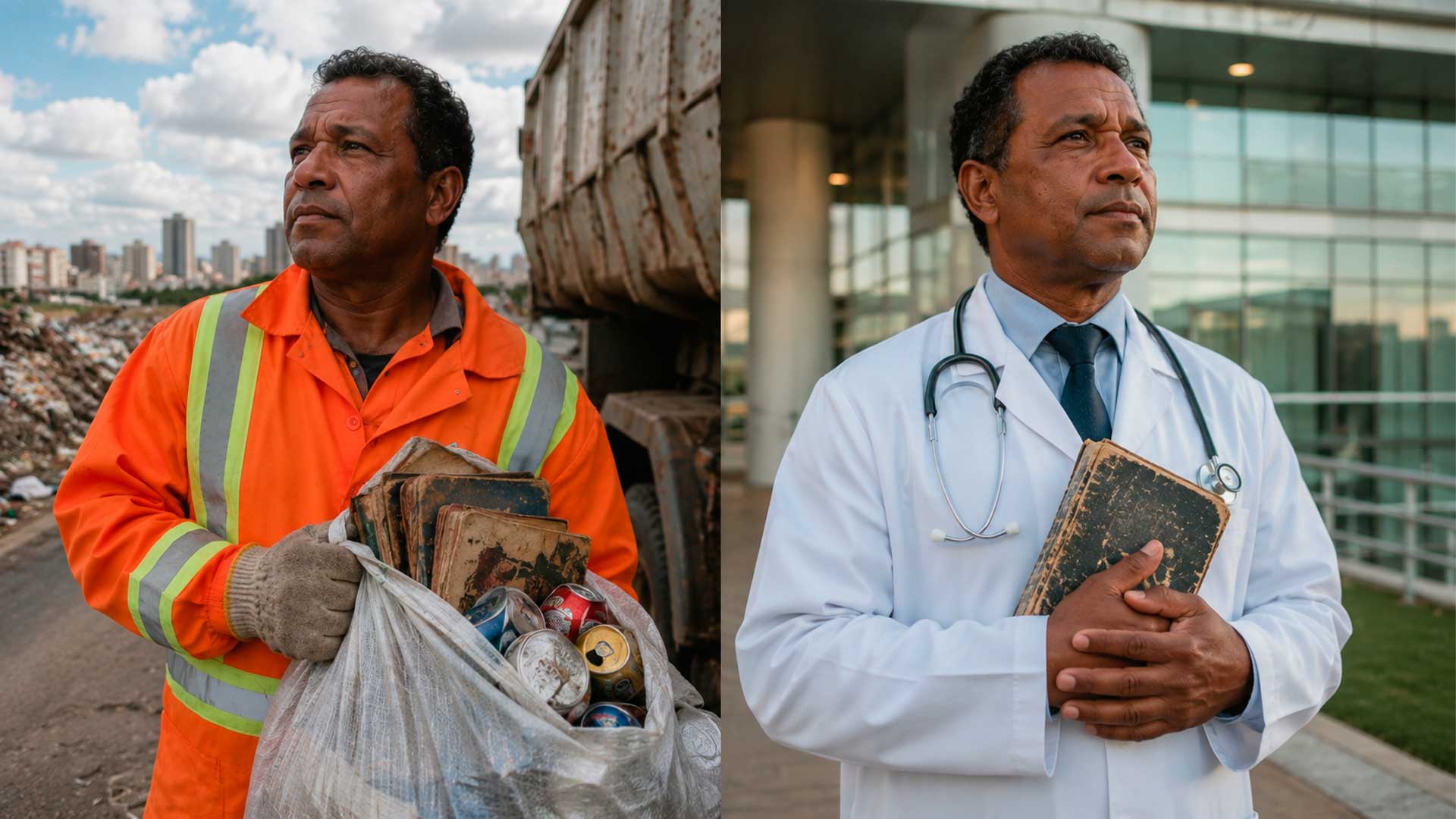
From Collecting Trash in Brazil to Becoming a Doctor: Cícero’s Journey with a Full Scholarship


The district where the beach turned into ruins
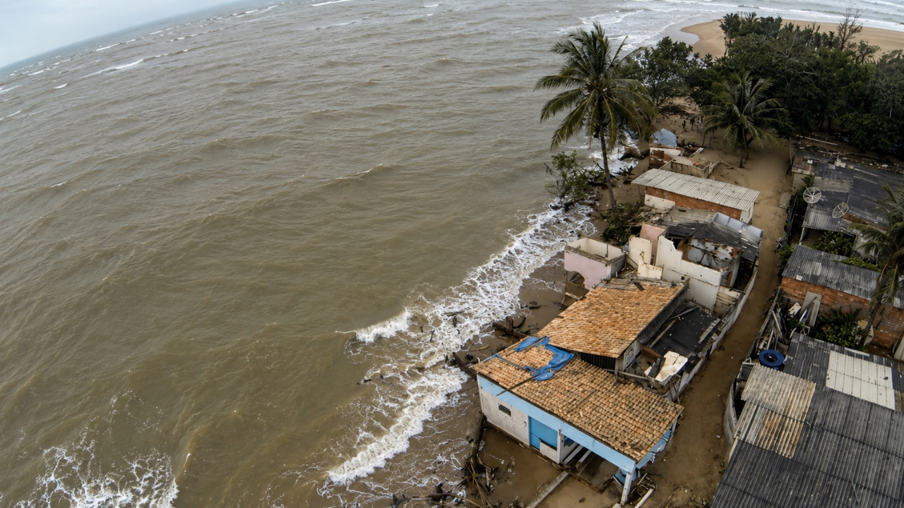
Atafona is located in a sensitive region: the mouth of the Paraíba do Sul River, where the meeting of river, sea, wind, waves, and sediments defines the stability of the coast. When this balance is disrupted, the beach stops receiving enough sand and the sea begins to gain ground.
According to the report by Mongabay, republished by UOL, the average sea advance in Atafona reaches 3 meters per year. National Geographic Brazil provided another perspective: erosion advances an average of 2.7 meters per year, but has reached 8 meters in some periods, such as between 2008 and 2009.
These numbers help explain why residents speak of a city that is disappearing little by little. It’s not just about a lost strip of sand. What is at stake is urban territory, family memory, fishing, tourism, and safety.
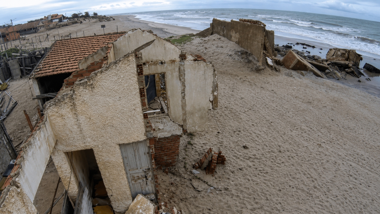
More than 500 buildings and 14 blocks
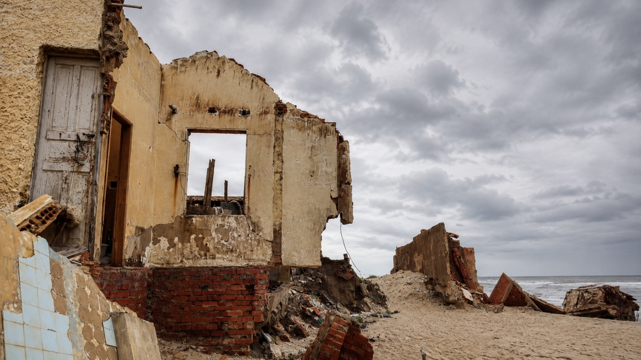
National Geographic Brazil states that more than 500 buildings have already been destroyed in Atafona and that 14 blocks have been completely submerged since the acceleration of the erosive process. Among the structures mentioned in the reports are houses, bars, markets, a four-story hotel, a school, a boat fuel station, churches, and vacation homes.
The image of the ruins has become part of the local landscape. In some areas, remnants of walls, concrete, and ironwork appear where there were once streets and residences. For visitors, the scene may seem touristic. For residents, it is the concrete reminder of a loss that has not ended.
Eco reported that even Civil Defense signs have started to warn about areas unsuitable for swimming due to the debris. The risk is not only in the advance of the water but also in the remains of the constructions destroyed by the sea.
The problem began decades ago
Erosion in Atafona is not recent. The research cited by Mongabay points to records on the Island of Convivência since 1954. A few years later, the process also appeared on Atafona beach and intensified from the 1970s onwards.
A study published in 2024 in the Brazilian Journal of Geomorphology, with authors linked to UFF, analyzed the coastline between 1954 and 2018. The work identified continuous erosion near the mouth, with an approximate rate of 5 meters per year in Atafona.
The same study points out that, between 1976 and 2019, erosion affected an area equivalent to 12 blocks. Another survey presented in the Sinageo proceedings showed that, between 2005 and 2016, 40 buildings were lost, 7 blocks were affected, and the eroded area reached about 29,000 square meters.
The river lost strength and the beach lost defense
The sources consulted do not treat Atafona as a case caused by a single factor. The advance of the sea is associated with a combination of elements: reduction of the strength of the Paraíba do Sul river, dams, water diversions, silting, less arrival of sediments to the beach, wave dynamics, winds, tides, vulnerable urban occupation, and more intense climatic events.
The central point is the lack of sediments. When the river carries less sand to the mouth, the beach loses part of its natural replenishment. The sea continues to remove material from the coast, but the river can no longer return it in the same proportion.
Eco highlighted that the Paraíba do Sul supplies more than 14 million Brazilians and mentioned the diversion of about two-thirds of the river to the Guandu system, used in the supply of the Rio Metropolitan Region. Meanwhile, UFF mentions a reduction of almost 30% in a survey on the delta. The Brazilian Journal of Geomorphology cites a drop of about 35% in the lower course between 1934 and 2015.
The percentages vary because they refer to different measurements and periods. Even so, they all reinforce the same context: the river became less capable of sustaining the coast.
Residents live between displacement and memory
The human impact appears in the stories of those who saw the water approach their doorstep. Mongabay cited residents who watched walls fall, streets disappear, and families leave properties once considered safe.
National Geographic Brazil also reported cases of families who lost successive homes. Eco recorded the story of residents connected to fishing who remained close to the sea because they depend on it for work, even with the increasing risk.
Thus, Atafona is not just an environmental case. It is a forced change in the lives of those who built routine, income, and memory in an area that no longer offers the same stability.
The future still depends on studies and costly choices

There is no simple consensus on a definitive solution. Researchers cited by Eco mention alternatives such as groynes, breakwaters, dredging, artificial beach nourishment, and sand transposition. All require high cost, maintenance, and impact assessment.
In 2026, the São João da Barra City Hall reported progress in the process to hire a technical, economic, and environmental feasibility study aimed at coastal erosion in Atafona and Açu. The city hall itself announced the selection of a company for this study in April 2026.
The challenge is that any construction needs to consider the dynamics of the coast. Intervening in one section can shift the problem to another, especially in a region where river and sea function as parts of the same system.
An alert that goes beyond Atafona
Folha published, based on a UN report and a tool from NASA scientists with IPCC projections, that Rio de Janeiro and Atafona may record an average sea level rise of 16 centimeters between 2020 and 2050. The report also states that the two areas have already observed a rise of 13 centimeters between 1990 and 2020.
Therefore, Atafona matters beyond its ruins. The district shows how a city can disappear not by an instant disaster, but by a sum of decisions, environmental pressures, and accumulated changes. What the sea took there was not just sand. It was streets, houses, businesses, and the visible proof that the Brazilian coast is already experiencing problems that can no longer be treated as a distant future.