
 Portuguese
  Spanish
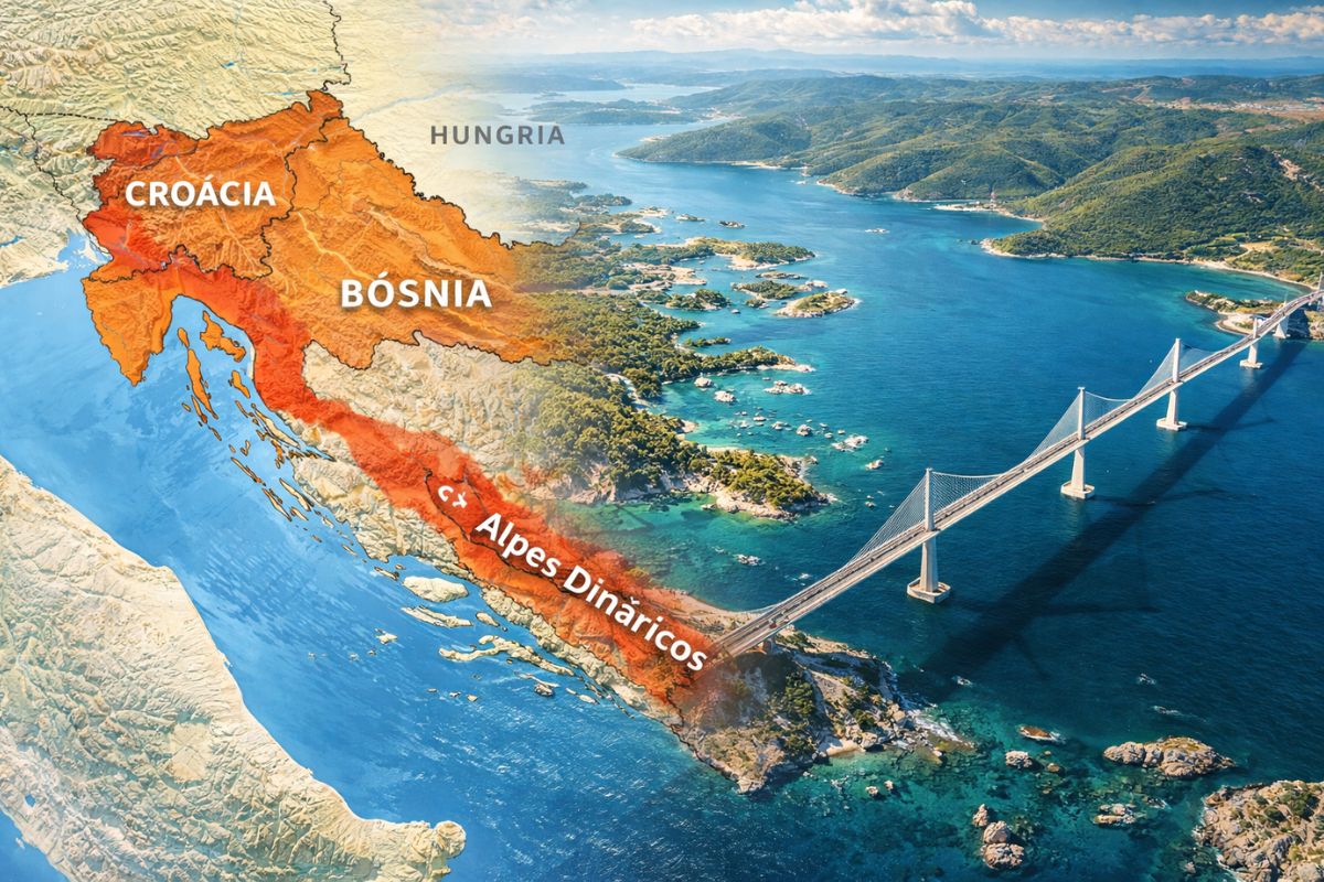
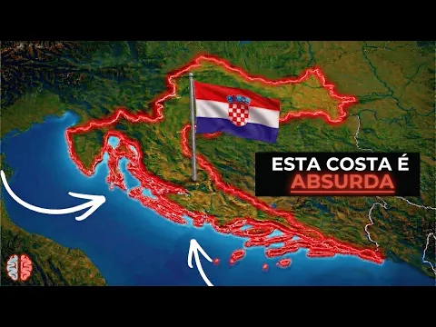
The map shows a crooked coastal country: Croatia concentrates almost all the beach around it, sums 5,830 km of coastline, more than 1,200 islands, and gained a giant bridge inaugurated in 2022
On the map, Croatia does not present itself as a “normal” block of territory. It looks like a boomerang, or even a dragon’s jaw, with Zagreb as the “eye,” drawing a contour that catches attention at first glance and creates a direct effect on its neighbors.
The result of this shape is quite concrete: on the map, Croatia “embraces” the coast and leaves Bosnia with a tiny corridor of 20 km to access the sea, while it compensates with a gigantic coastline, a huge archipelago, and a bridge that only appeared in 2022 to solve a geographical problem that divided the country.
A shape that the map delivers in two lines

According to the video, Croatia appears almost like a geography joke: “Croatia swallows Bosnia.” The image is exaggerated, but the map provides ammunition for this reading, as the country stretches along the coast for more than 500 km, but in a crooked way, as if it had decided to “keep” the Adriatic for itself.
-
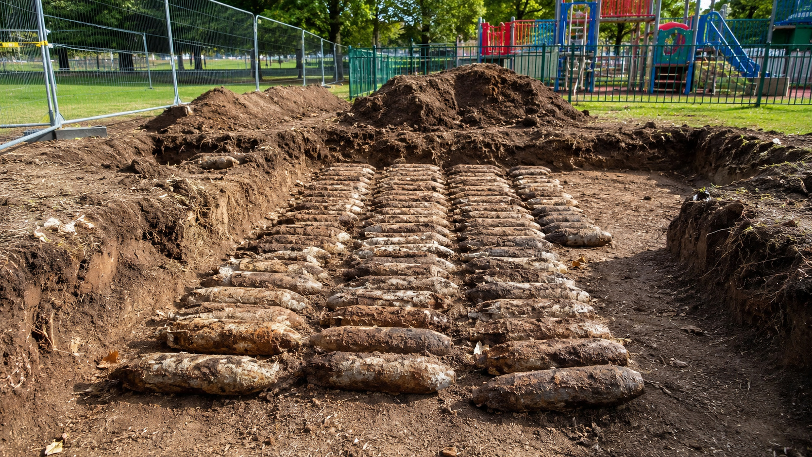
Workers renovating a playground in northern England uncover 176 World War II bombs buried underground; training artifacts still contained explosives.

-
Brazilian Architect Transforms Waste into Sustainable Homes with Solar Power and Rainwater Systems for 40 Years

-
Security Guard Becomes Doctor at Louisiana Hospital Where He Once Worked, Studied Chemistry Between Shifts

-
Woman Rescued from Luxury Complex in Brazil Worked Without Pay for 55 Years, May Be Entitled to Over $300,000


This “absurd” shape appears when you follow the outline of the country: instead of a continuous and simple drawing, Croatia stretches, bends, contours, and creates passages that seem made to block others’ paths.
The 20 km corridor on the map left for Bosnia

The most striking point of the map is Bosnia’s access to the sea. Bosnia is left with a corridor of only 20 km, described at the base as a minimal space to “breathe” on the coast, while Croatia retains almost all the remaining coastline around.
That is why the base calls this “the greatest geographical theft in Europe.” The expression is provocative, but it conveys the feeling that the shape of the territory gives to those who observe the map without context: a country with a lot of sea and a neighbor practically cornered.
The same logic appears in the north with Slovenia

Jacques Disse Geo says that Croatia repeats the geographical “trick” with Slovenia in the north. The idea, again, is not a technical border fact, but rather the impression that the map conveys, of a country that “opens its arms” and creates passage limitations.
This type of shape helps explain why Croatia is often cited as an example of a border that does not seem “natural” when you look at the map for the first time.
Dinaric Alps: the line that separates the coast from the interior
The shape of Croatia is not curious only because of the coastline. The base highlights a mountain range, the Dinaric Alps, crossing the country and separating the coast from the interior.
This creates a very clear division: on one side, coastal Croatia, associated with Dalmatia, and on the other, continental Croatia, referred to in the base as Slavonia. The map does not only show political boundaries; it suggests two worlds within the same territory.
The giant bridge of 2022 that “stitched” the country together

Because of that famous stretch of Bosnian coast, the base states that Croatia was physically divided in two until very recently. To travel from north to south, it was necessary to cross a border.
The turning point came in 2022 when they built a huge bridge to circumvent the problem. In practice, this bridge redrew the internal path of the country and transformed a piece of the map into something less constrained for movement.
5,830 km of coastline and more than 1,200 islands change the game
If the neighbor has a minimal piece of sea, the source says that Croatia has one of the longest coastlines in the world, with 5,830 km. And a good part of this comes from the number of islands: more than 1,200, a total that the source compares as superior to that of the Bahamas or Maldives.
In addition to quantity, there are curiosities: the source mentions Carca or CRES, islands that are exactly the same size and compete for the title of the largest island in the country. On the map, this reinforces the idea that Croatia is not just a continent; it is an archipelago spread along the coast.
A small country on the inside, giant on the outside
Croatia has only 3.8 million inhabitants, according to the source. But there is a massive diaspora: it is estimated that more than 4 million descendants of Croats are spread across countries like Germany, the United States, and Argentina.
This contrast affects the perception of the human map of the country: there are more Croats outside than inside, which creates a cultural presence that goes beyond the territory.
Independence in 1991 and rapid integration into Europe
The source highlights that Croatia is a recent country as an independent state: it has existed since 1991, after the fall of Yugoslavia and its declaration of independence.
Even so, it would have developed rapidly, integrating into the Schengen area and adopting the euro. On the political map of Europe, this helps explain why Croatia appears today more connected to the European bloc than its age as a country would suggest.
A postcard that contrasts with the “strange” map
After all the talk about crooked shapes and unusual borders, the source describes Croatia as a visual spectacle.
Among the crystal-clear waters of the Adriatic, medieval walls of White Stone, Venetian heritage with red-tiled roofs, and the emerald green waterfalls of Plitvice Park inland, the country turns into a life-sized postcard.
In the end, the map may be the trigger of curiosity, but Croatia seems to gain strength precisely in the contrast: a strange geographical design on the outside, and a set of striking landscapes on the inside.
Which country, in your opinion, has a map shape that always seems “out of the ordinary” when you first glance at it?


