Portuguese
  Spanish
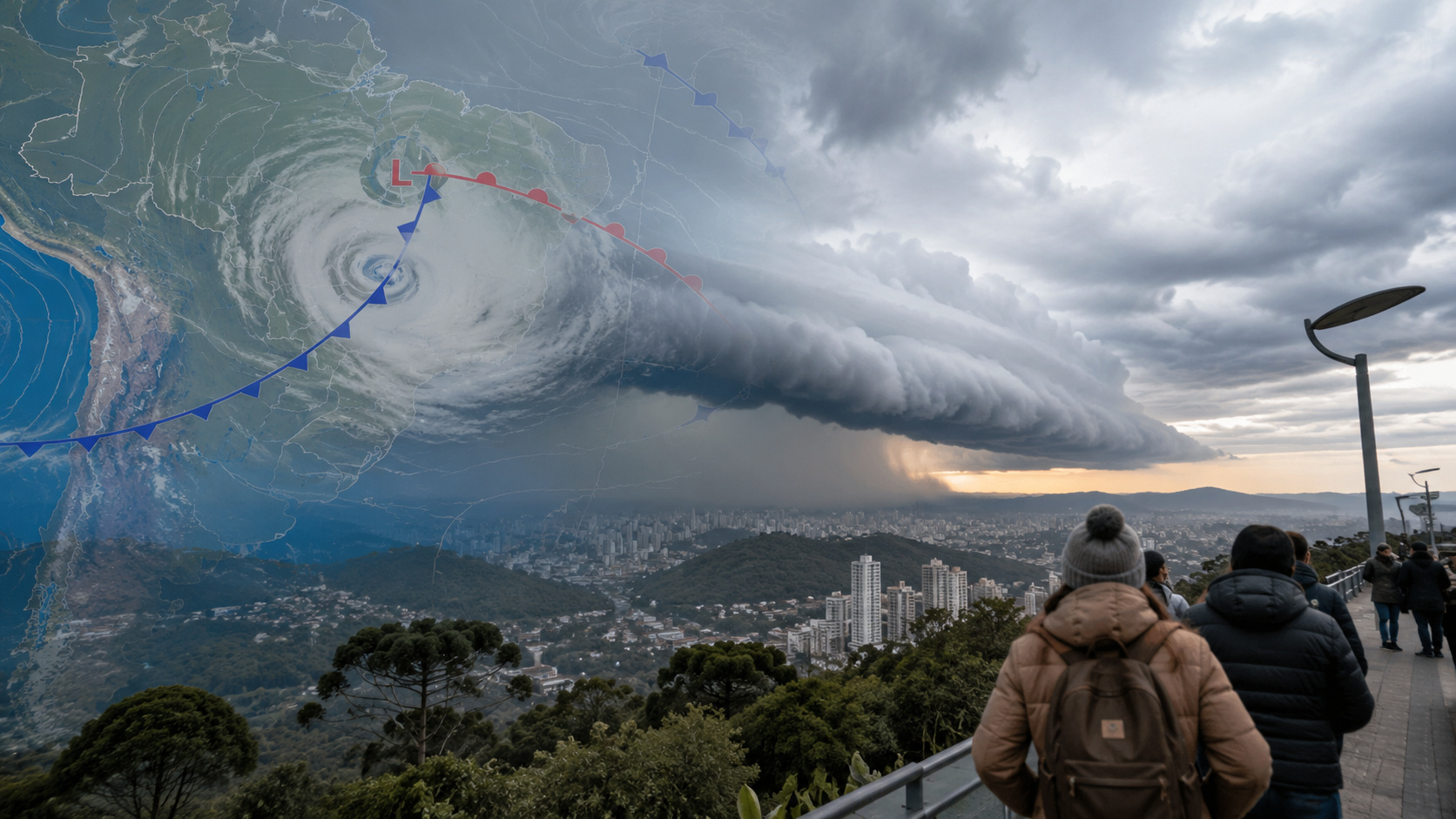
Formation of a cyclone in the South of the country and the arrival of a powerful polar air mass are expected to cause one of the most significant weather changes at the beginning of June, with heavy rain, intense cold, and the possibility of frost in various areas of Brazil.
A new change in weather conditions is expected to affect a large part of Brazilian territory in the coming days. According to information released by Meteored, the formation of a low-pressure system associated with a cold front will give rise to a cyclone in the Southern Region, while an intense polar air mass will advance over the country. The phenomenon is expected to cause rain, a sharp drop in temperatures, and the possibility of frost between June 8 and 15.
The meteorological scenario is noteworthy because it occurs right after a week marked by below-average temperatures in various Brazilian regions. In recent days, a cold air mass has already been influencing the climate in the South, Southeast, Midwest, and even part of the Northeast, keeping thermometers at lower levels than usual for this time of year.
The expectation now is for a new intensification of this pattern, expanding the impacts on millions of Brazilians.
-
The Trap of Modern Technology: How Screen Overload and Digital Connections Can Impact Your Mental Health and Well-being

-
Wyoming Couple Grows Tropical Fruits Year-Round in -40°C Using Geothermal Greenhouse, Demonstrating Earth’s Heat Can Produce Oranges and Lemons in Snow Without Traditional Heating

-
Ship Returns from Brazilian Coast with Thirty Newly Discovered Life Forms
-
Nigerian Professor Invents Electricity-Free Refrigerator Using Clay Pots and Wet Sand, Extending Shelf Life of Vegetables to 27 Days; 7,000 Units Distributed in Energy-Deprived Villages


System begins to form in the South and favors the advance of rains
According to the report published by Meteored, the change process begins to gain strength starting Saturday, the 6th, when an area of atmospheric low pressure, known by meteorologists as a trough, begins its deepening over the Southern Region.
This system emerges in the wake of a cold front and favors the increase of cloudiness over Rio Grande do Sul and Santa Catarina. As a consequence, areas of these states may already record light rains and increased atmospheric instability.
On Sunday, the 7th, the situation becomes more significant. The forecast indicates more expressive rain showers over Rio Grande do Sul, accompanied by greater cloud cover and intensification of winds in some locations.
By Monday, the 8th, the system advances and begins to influence Santa Catarina, Paraná, and Mato Grosso do Sul. Subsequently, on Tuesday, the 9th, the instability reaches areas of the Southeast Region, expanding the phenomenon’s scope.
Meanwhile, meteorological models indicate that the system will continue to develop throughout the week until it reaches characteristics typical of an extratropical cyclone.
The predicted rainfall accumulations are noteworthy. Some areas in the south of Rio Grande do Sul, Mato Grosso do Sul, and the São Paulo coast may record volumes between 50 and 75 mm throughout the week, numbers considered significant and capable of causing localized disruptions, especially in areas with poor urban drainage.
Polar air mass intensifies the cold and increases frost risk
In addition to the rains, another factor concerning specialists is the arrival of a new intense polar air mass.
According to the meteorological data released, the advance of the cold air will begin to be felt on Monday, the 8th. However, its effects will become more evident in the following days, when temperatures will drop more sharply in different states.
By Thursday, the 11th, the cold is expected to affect a large part of the Southern Region, as well as areas in the Southeast and Midwest.
The lowest temperatures are forecast for Rio Grande do Sul, Santa Catarina, Paraná, São Paulo, southern Minas Gerais, and southern Mato Grosso do Sul. In these locations, the minimums may fall below 10°C, significantly increasing the favorable conditions for the formation of localized frosts.
This scenario requires special attention from farmers, drivers, and residents of areas more vulnerable to intense cold, as frosts can cause impacts on agriculture and difficulties for the population in certain regions.
Moreover, the polar air is also expected to influence parts of Mato Grosso, Goiás, the Federal District, Minas Gerais, and Espírito Santo. There is also the possibility of the cooling reaching areas of Bahia during the second half of the week.
Below-average temperatures are expected to mark the week between June 8 and 15
Climate models indicate that the joint action of the cyclone and the polar air mass will result in a significantly colder week than usual for this time of year.
The temperature anomaly projections show values below average in a wide range of the national territory, covering states in the South, Southeast, and Midwest.
Among the places expected to feel the effects more intensely are Paraná, São Paulo, and Mato Grosso do Sul, where the cold may persist for several consecutive days.
Experts highlight that episodes like this are common during the meteorological winter, but the intensity forecast for this new polar air incursion warrants constant monitoring of meteorological updates.
In this scenario, the recommendation is for the population to follow official weather forecast bulletins, especially those related to their city or region. This allows for adequate planning for travel, outdoor activities, agriculture, and protection against low temperatures.
With the system’s approach, the coming days are expected to be marked by rapid changes in atmospheric conditions, reinforcing the importance of paying close attention to forecasts.
Original source: Meteored Brasil.