
 Portuguese
  Spanish
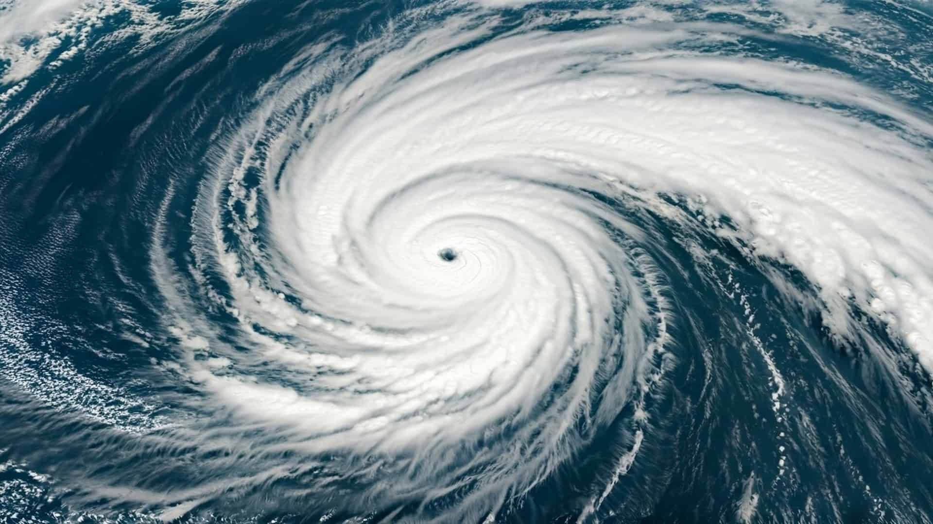
An extratropical cyclone in the Atlantic Ocean keeps southern Brazil on alert and paves the way for the entry of a polar air mass capable of bringing the thermometer to zero degrees in the mountains of Santa Catarina and Rio Grande do Sul. Frost is forecast for the weekend and storms between Paraná and Santa Catarina.
On May 21, 2026, Thursday, the Civil Defense of Santa Catarina, the National Institute of Meteorology (Inmet), and the Marine Meteorological Service of the Brazilian Navy issued joint alerts for the advance of a polar air mass over the South of the country, driven by an extratropical cyclone active in the Atlantic Ocean. According to the agencies, the system keeps the coast between Rio Grande do Sul and Santa Catarina under a bad weather warning, with waves up to 3 meters, and paves the way for intense cold, with minimum temperatures that can reach zero degrees in the mountains of Santa Catarina and Rio Grande do Sul between Friday (22) and Saturday (23).
The advance of this polar air mass is the central point of the alert. According to Inmet, in addition to the sharp drop in temperature, frost is forecast in the mountains of Santa Catarina between Friday and Saturday, while instability areas are expected to cause storms between Paraná and Santa Catarina, with heavy rain in the south-central of São Paulo over the weekend. The combination of rough seas on the coast, freezing cold inland, and localized storms creates a scenario of heightened attention for residents, fishermen, farmers, and drivers throughout the Southern Region of Brazil.
How the cyclone paved the way for the polar air mass
The phenomenon begins in the ocean. An extratropical cyclone is a low-pressure system that forms from the meeting of air masses with different temperatures, common in the South Atlantic at this time of year. As it spins and moves, this cyclone acts like a kind of pump that pulls cold air from the southernmost latitudes of the continent towards Brazil. It is precisely this movement that paves the way for the advance of the polar air mass over Brazilian territory.
-
17-Year-Old Brazilian Develops AI to Aid Students with ADHD and Dyslexia, Capturing Google’s Attention with Flexia

-
Internet Cables Installed Under Cities Detect Over 100 Water Leaks in Three Months, Cover 650 Kilometers, and Help Save 2 Million Liters Daily

-
Australia Plans to Export Desert Solar Energy to Singapore via 4,300 km Undersea Cable in a $35 Billion Project
-
Archaeologists Discover 9,000-Year-Old Stone Hammer with Perfect Hole During Routine Inspection for Norwegian Bike Path


In practice, the cyclone and the polar air mass act complementarily. While the low-pressure system causes strong winds, rough seas, and swells on the coast, the polar air advancing behind it drops temperatures inland. This sequence explains why, in a few days, the South of Brazil goes from a milder pattern to a scenario of freezing cold, with a risk of frost. The entry of the polar air mass is the second chapter of a process that begins with the cyclone offshore.
Freezing cold and frost in the mountains of Santa Catarina and Rio Grande do Sul

The Civil Defense of Santa Catarina predicts intense cold especially between Thursday night (21) and Friday morning (22), with the possibility of frost in the mountainous regions over the weekend. In recent years, similar episodes have recorded negative minimums in cities like São Joaquim and Urupema, in the Santa Catarina mountains, and in municipalities of Campos de Cima da Serra, in Rio Grande do Sul.
Frost forms when the temperature near the ground drops to very low levels, with clear skies and low humidity in the air during the early morning. Under these conditions, the water vapor present on the surface freezes, forming the characteristic thin white layer on plants, roofs, and vehicles. For agriculture, this phenomenon requires special attention, as frost can damage sensitive crops, vegetables, and pastures. The arrival of the polar air mass makes this risk concrete for producers in the higher regions of the South of the country this weekend.
Waves up to 3 meters and rough seas on the coast of SC and RS
Even before the cold arrives with force, the cyclone is already causing effects at sea. The Marine Meteorological Service of the Brazilian Navy issued a bad weather warning for the coastal strip between Rio Grande do Sul and Santa Catarina, with a forecast of South to Southeast direction waves up to 3 meters high between Thursday night (21) and Friday morning (22), in the stretch between Mostardas, on the gaucho coast, and Florianópolis, the capital of Santa Catarina.
The Civil Defense of Santa Catarina detailed that the sea becomes especially rough between Greater Florianópolis and the Southern Coast, with waves between 2 and 3 meters and peaks that can reach 3.5 meters. The agency classified the risk as high for occurrences related to maritime agitation, especially in fishing, navigation, and nautical sports activities. The phenomenon occurs due to the so-called swell, undulations formed in the open sea by the cyclone’s wind, which travel long distances until reaching the coast, even after the system moves away from the coast. Even far from the coast, the cyclone that precedes the polar air mass is already felt at sea.
Storms between Paraná and Santa Catarina and heavy rain in São Paulo
As the cold advances through the interior, instability areas associated with the same system are expected to cause storms between Paraná and Santa Catarina, according to Inmet. These storms may be accompanied by lightning, wind gusts, and intense rain in a short period, increasing the risk of localized flooding, falling trees, and traffic disruptions in both regions. The civil defense agencies advise avoiding flood-prone areas and makeshift shelters during the strongest downpours.
In the south-central region of São Paulo, heavy rain is forecasted for Saturday as the cold front associated with the system moves towards the Southeast. This pattern of concentrated rain, followed by a drop in temperature, is typical of the passage of cold fronts driven by a polar air mass. Meteorologists recommend closely monitoring updated warnings, as the intensity and exact location of the storms may vary depending on the cyclone’s movement and the pace of the polar air entering the continent.
The contrast with heat and rain in the Northern Region of Brazil
While the South faces intense cold, rough seas, and frost risk, the Northern Region of Brazil remains in an opposite scenario. Inmet’s forecast indicates showers and thunderstorms, especially in the states of Amazonas, Amapá, Roraima, and Pará, with accumulations that can exceed 70 millimeters in some areas. This contrast is a striking feature of the Brazilian climate, where the same atmospheric configuration produces radically different effects depending on the latitude.
The explanation lies in the dynamics of air masses. While the polar air mass pushes the cold from the extreme south of the continent towards Brazilian territory, the North remains under the influence of humid tropical systems, favoring the formation of intense convective rains. This climatic mosaic, with record cold in the South and humid heat in the North at the same time, highlights how a single country of continental dimensions can experience completely different meteorological realities on the same day. The action of the polar air mass is just the most visible piece of this atmospheric puzzle.
How to prepare for the arrival of the polar air mass in the South
In light of the alert, civil defense agencies recommend a series of precautions. For the cold, the advice is to reinforce clothing, especially for children and the elderly, keep environments heated with adequate ventilation to avoid the accumulation of toxic gases from heaters, and pay attention to homeless people, who are the most vulnerable to low temperatures. Domestic and farm animals also need shelter on the coldest nights.
For rough seas, the recommendation is to avoid fishing, navigation, and water sports during the peak of the swell, and to be extra cautious in areas prone to coastal flooding. For frost, farmers should protect sensitive crops whenever possible. As for the storms, it is advisable to avoid risk areas and follow updated warnings from Inmet and state civil defenses. The passage of the polar air mass tends to be quick but requires concentrated attention in the coming hours and days throughout the Southern Region.
The episode brings together, in a few days, three phenomena that usually appear together in the fall and winter of Southern Brazil: the extratropical cyclone in the ocean, the rough sea on the coast, and the entry of the polar air mass inland. The result is a scenario of freezing cold, frost in the mountains, and localized storms, which requires preparation from the population and attention from public authorities. For a country with Brazil’s climatic diversity, closely monitoring each alert is the best way to reduce risks and damages.
How is the weather in your city with the arrival of this polar air mass? Do you live in a mountainous region and have you prepared for the possibility of frost this weekend? Leave your comment, tell us the lowest temperature you have ever faced in the South, and share the article with family, neighbors, and friends who need to protect themselves from the intense cold in the coming days.


