
 Portuguese
  Spanish
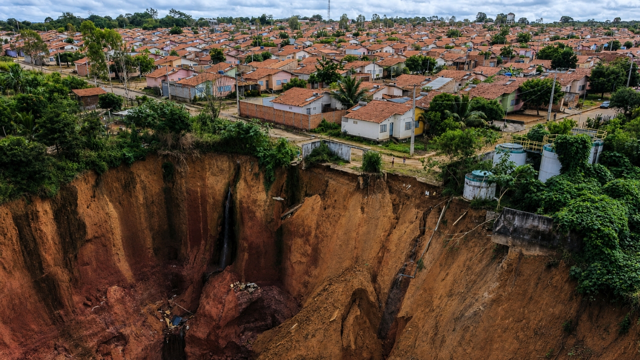
The gullies advancing in the interior of the Northeast expose an urban crisis marked by fragile soil, intense rains, disorderly occupation, and drainage failures. The problem threatens about 1,200 residents and places hundreds of houses in high-risk areas.
The land is giving way.
In Buriticupu, in the interior of Maranhão, huge gullies advance near houses, streets, and buildings, creating one of the most impactful urban images in the country. The problem did not start now. According to the Geological Survey of Brazil, the erosive process has been monitored since 2014, but it has been ongoing for decades and gained strength with rains, sandy soil, disorderly occupation, and lack of adequate drainage.
The strongest data appears in Decree No. 002/2025 of the Municipality of Buriticupu. The municipality declared a public calamity in areas affected by erosions and pointed out about 1,200 people, in approximately 250 homes, living in high-risk situations.
-
Elderly Man in His 70s Spends Nearly 30 Years Digging 3 km Canal to Transform Arid Land into Farmland in Rural India

-
Submerged Town Reemerges in São Paulo as Reservoir Levels Drop, Revealing Ruins and Memories of Displaced Families
-
Astronauts Returning from Space Show Altered Gut Bacteria and Loss of Protective Microbes, Highlighting Potential Risks for Mars Missions

-
São Paulo to Convert Historic Downtown Building into Affordable Housing for Low-Income Families


What are the craters advancing through the city

Although popularly called craters, the formations are gullies, deep erosions mainly caused by the action of rainwater on fragile and unprotected soils.
The Geological Survey of Brazil explains that the phenomenon can advance rapidly, especially during the rainy season. In Buriticupu, the terrain has a sandy and very friable substrate, a condition that facilitates the growth of small, medium, and large-scale erosions.
This combination helps to understand why the landscape has changed so much. What starts as an opening in the soil can turn into a large ravine, swallowing sections of streets and leaving houses on the edge of the void.
1,200 residents live at risk in affected areas
The municipal decree cites neighborhoods such as Caeminha, Centro, Vila Isaías, Santos Dumont, Eco Buriti, Terra Bela, Sagrima, and Terceira Vicinal among the affected areas. The situation led the Municipality to authorize emergency measures, such as evacuation in case of imminent risk, use of private properties in situations of public danger, and emergency contracting for works and services related to the disaster.
The numbers vary according to the source and the year analyzed. The Geological Survey of Brazil had already pointed out, in a 2018 assessment, about 1,400 people in ten high geological risk locations. The 2025 decree speaks of 1,200 people and about 250 homes at high risk.
From 26 to 33 gullies, according to surveys
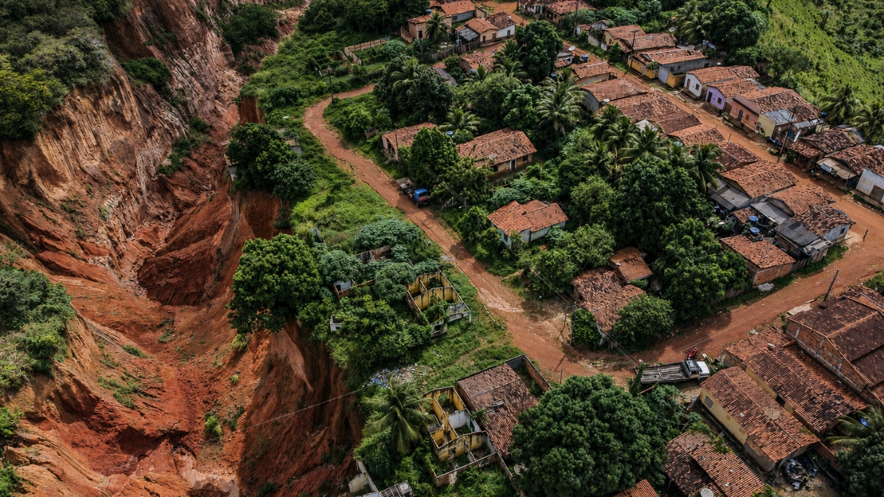
In 2023 and 2025, official sources and reports cited 26 gullies in Buriticupu, some up to 600 meters long and 70 meters deep, according to information gathered by the Ministry of Integration and Regional Development.
In 2026, the Institute for Technological Research reported that the municipality already had 33 craters. Technicians analyzed about 25 points with active erosive processes to prepare diagnostics and containment recommendations.
A study on the spatial evolution of the gullies between 2014 and 2022 indicated a 74.76% increase in total length and a 104.01% increase in degraded area. The same research identified a risk to the integrity of buildings in 18 gullies.
Rains, fragile soil, and city without adequate drainage
The explanation is not in a single factor. Studies cited by GeoUECE Magazine relate the advance of the gullies to soil erodibility, irregular terrain, road impermeabilization, the direction of rainwater and sewage to slopes, and the occupation of vulnerable areas.
Agência Brasil interviewed Professor Marcelino Farias from the Federal University of Maranhão, who classified Buriticupu as a case of poor urban soil use. The assessment points to a dangerous mix: fragile terrain, deforestation, lack of planning, and absence of efficient drainage projects.
The result appears in the daily lives of residents. Houses are close to unstable edges, streets lose continuity, and families live in fear that a new rain will widen the cracks in the ground.
Works, Justice, and pressure for answers
The Ministry of Integration and Regional Development recognized the emergency situation in February 2025, allowing the municipality to request federal resources for civil defense actions. The department also reported the transfer of R$ 32.9 million in August 2024 for civil defense actions, projects, and drainage works in Buriticupu.
In the judicial sphere, the Public Prosecutor’s Office of Maranhão filed a Public Civil Action in 2022. In 2025, the court ordered measures such as isolation and signage of risk areas, updating the registry of families, social rent for residents at imminent risk, and a construction plan.
In 2026, the Public Prosecutor’s Office reported that the court denied a new deadline to the City Hall and demanded proof of obligations, with a fine foreseen in case of non-compliance.
Buriticupu is more than a city marked by giant holes. The case shows how the lack of urban planning, drainage, and environmental protection can turn rain into a permanent threat, pushing families to live daily with the risk of seeing their own neighborhood gradually disappear.


