
 Portuguese
  Spanish
Weather change is expected to advance rapidly across Brazil, with storms, strong winds, and a new drop in temperature in the South, Southeast, and Midwest states, while a cold front associated with a cyclone reorganizes areas of instability between the weekend and the beginning of July.
A new cyclone associated with a cold front is expected to change the weather in Brazil between the weekend and the beginning of next week, with forecasts of storms, heavy rain, strong winds, and a new drop in temperature in the South, Southeast, and Midwest.
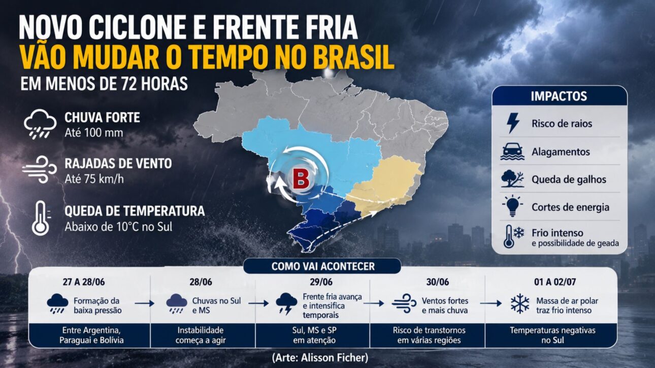
According to Meteored, the system’s formation begins between Saturday (27) and Sunday (28), when a low-pressure area is expected to deepen between Argentina, Paraguay, and Bolivia, favoring the organization of heavy clouds.
Before reaching areas of the Southeast, the instability is expected to hit Mato Grosso do Sul, Paraná, Santa Catarina, and Rio Grande do Sul, where there are conditions for rain showers still during the weekend.
-
Brazilian School Network Turns 7 Tons of Recyclables into 43 Wheelchairs, Aiming to Break Record by 2026

-
194-Year-Old Giant Tortoise, World’s Oldest Living Land Animal, Honored by Guinness for Birth Predating Victorian Era, Eiffel Tower, and Tower Bridge
-
Autonomous Toilet with UV Cleaning Available for Purchase at $13,000

-
Drone Reveals Abandoned 55-Story Luxury Residential Tower in Northeastern Brazil Since 2017


Subsequently, the cold front associated with the cyclone is expected to advance between Monday (29) and Tuesday (30), increasing the risk of storms also for São Paulo and maintaining a very unstable atmospheric scenario.
Rapid weather change
The formation of the cyclone occurs after the passage of a cold front that had already caused rain and a drop in temperature in parts of the country, especially in areas of the South, Southeast, and Midwest regions.
The National Institute of Meteorology reported that a frontal system advanced through Brazil this week and maintained conditions for rain and cold in these regions, creating a favorable environment for the continuation of instabilities.
With the arrival of the new system, the atmosphere becomes unstable again in less than 72 hours in areas still feeling the effects of the cold, reinforcing the rapid change in the weather pattern.
According to Meteored’s projections, the cyclone is expected to act accompanied by a cold front and a polar air mass, a combination capable of maintaining heavy rain and below-average temperatures at the beginning of July.
Between Sunday (28), Monday (29), and Tuesday (30), the risk of storms is expected to be higher in the southern states, in Mato Grosso do Sul, and in São Paulo, where the cold front is expected to gain strength.
In these areas, the joint action of the cyclone and the cold front is expected to favor heavy rain, lightning, and wind gusts, with the potential for disruptions in cities and rural areas.
Heavy rain may reach 100 mm
The projections released by Meteored indicate rain of up to 50 millimeters per hour, with totals close to 100 millimeters in some municipalities, especially during periods of greater organization of the heavy clouds.
In coastal areas, wind gusts can reach 75 km/h, which increases the risk of disruptions in cities more exposed to instability and requires attention to rapid changes in weather conditions.
When high volumes of rain occur in a short interval, the chances of flooding, falling tree branches, and small power outages increase, especially in more vulnerable urban areas.
The forecast also indicates a risk of lightning in the affected states, especially during the intensification phase of the storms, when the system finds favorable atmospheric conditions to form heavier clouds.
In the countryside, the combination of intense rain and strong wind can hinder rural activities in the South and part of the Midwest, especially in regions where the soil is already saturated.
In the cities, the most likely impacts involve water accumulation on roads, occasional power outages, and disruptions in commuting, especially during peak hours as the storms pass through.
Cold front advances with polar air
In addition to the rain, the system is expected to pave the way for a new mass of polar air starting Monday (29), although the more intense temperature drop is forecast for Tuesday (30).
At this time, thermometers may again drop below 10°C in the South region and in the south of Mato Grosso do Sul, reinforcing the winter pattern after the passage of the cold front.
In the first days of July, the cold air is expected to gain intensity and increase the sensation of cold in parts of the country, especially in higher areas and those further from the coast.
Between Wednesday (01) and Thursday (02), Meteored forecasts negative temperatures in the South region, especially in Rio Grande do Sul and Santa Catarina, with greater emphasis on mountainous areas during the early morning.
The forecast indicates a typical winter pattern, with persistent cold and the possibility of frost in higher points, although the episode is not expected to be as intense as the cold wave recorded this week.
Even so, the polar air mass should be sufficient to keep temperatures below average in parts of the South, prolonging the feeling of cold after the phase of more intense rain.
States under greater attention
Rio Grande do Sul, Santa Catarina, and Paraná should concentrate an important part of the system’s effects, both from the rain and the entry of cold air, as they are closer to the area of greatest instability.
Mato Grosso do Sul appears in the area of influence of low pressure since the weekend, while São Paulo should feel the intensification of storms with the advance of the cold front.
The change in weather should occur gradually, starting with the organization of low pressure between neighboring countries and then advancing over Brazilian territory as the system gains strength.
Due to this displacement, rain showers appear first in the South and Mato Grosso do Sul, before reaching areas of the Southeast and increasing instability in São Paulo.
On the coast, greater attention is given to stronger wind gusts, which can increase the risk of disruptions in exposed areas and require constant monitoring of local forecasts.
In the mountainous regions, the highlight becomes the sharp drop in temperature after the passage of the cold front, with harsher dawns and the possibility of negative marks at the beginning of July.
Forecast indicates instability and temperature drop
Meteored attributes the change in weather to the formation of a low-pressure area that should give rise to the cyclone and reorganize instabilities over part of the country in the coming days.
The cold front linked to this system is the main mechanism for the intensification of storms between Monday (29) and Tuesday (30), when the risk of heavy rain should increase.
INMET, in turn, had already recorded the action of a frontal system in the country, with rain and cold in areas of the South, Southeast, and Midwest during this week.
This context helps explain the maintenance of an atmospheric pattern favorable to instabilities and temperature drop at the beginning of winter, especially in areas influenced by the cold front.
With the arrival of the polar air mass, the rain loses strength in part of the affected areas, but the cold begins to dominate the scenario in southern states and the south of Mato Grosso do Sul.
The combination of storms at the beginning of the period and low temperatures after the cold front should mark the transition from June to July in part of Brazil.
Therefore, monitoring local forecasts remains important, as rainfall volumes, wind gusts, and predicted minimums can vary from one city to another.
In systems of this type, small changes in the trajectory of the cold front alter the distribution of storms and the intensity of the cold, especially in transition areas between the South, Southeast, and Midwest.


