Portuguese
  Spanish
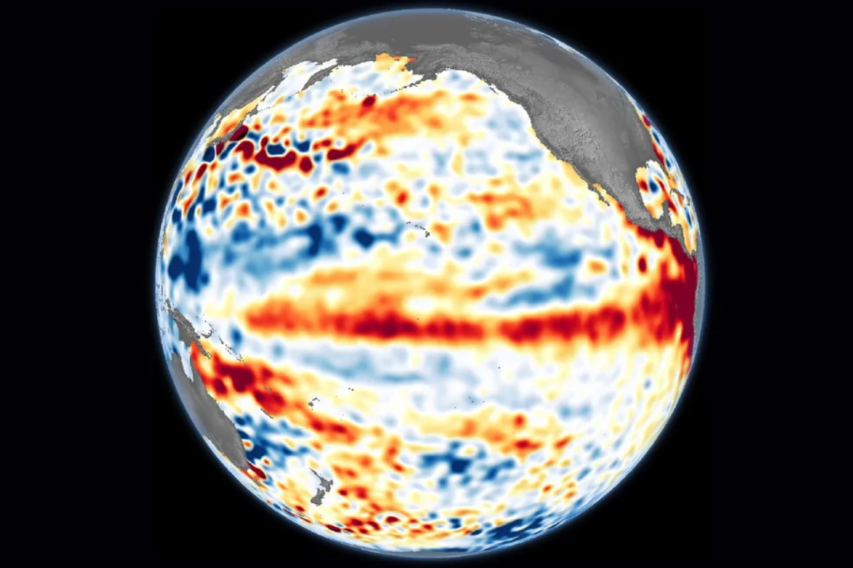
The abnormal warming of the Pacific is already raising alarms for changes in Brazilian climate in the coming months, with impacts on agriculture, water supply, and planning for a more unstable second half of the year.
Brazil may enter a new phase of climate attention as early as May. The trend is for the El Niño to advance, with rising temperatures and changes in rainfall patterns across various regions of the country.
In practice, this could mean more intense heat waves, flooding in the South, irregular rainfall in the Southeast and Central West, as well as stronger drought in the North and Northeast. The impact spreads and also affects agriculture.
What changes with the arrival of El Niño in Brazil
The El Niño occurs when the surface waters of the Pacific Ocean, along the equatorial line, become warmer than normal. This alters wind circulation and affects the climate in different parts of the planet.
-
Engineers Develop Fridge-Sized Machine to Produce 95-Octane Synthetic Fuel from Air and Water, Aiming to Sustain Combustion Engines Without Oil

-
Two-Armed Robot Uses AI to Reassemble Destroyed Pompeii Frescoes, Solving an “Impossible” Puzzle
-
New Law in Brazil Requires Breaks for Type 1 Diabetes Management at Work, School, and Public Exams

-
Scientists Confirm “Greening” of Antarctica: Ice on the World’s Coldest Continent Turns Green as Mosses Multiply Over Tenfold in Four Decades


With this change, Brazil usually feels very distinct effects between regions. The South tends to receive more rain, while the North and Northeast face reduced precipitation and a higher risk of drought.

May opens the window and August increases the risk
The forecast indicates a chance of occurrence as early as May. In the quarter of June, July, and August, the possibility of consolidation reaches 62% and continues to rise during the second half of the year.
Starting in August, the scenario becomes even stronger, with a probability exceeding 80% until the end of 2026. This raises the alert for persistent heat and more extreme weather events.
According to data released by NOAA, the U.S. agency for climate and oceans, the warming of the Pacific is already indicating an important change.
This movement reinforces the risk of heat waves, as well as opening the door for periods of irregular rainfall in the Southeast and Central West. In the South, concerns grow with storms and the possibility of flooding.
In the North and Northeast, the advancement of the phenomenon increases the chance of severe drought. States such as Maranhão, Tocantins, Piauí, and Bahia are among the most sensitive to this type of impact.
South may have excess rain and Northeast enters a zone of higher pressure
In the South, the combination of above-average rainfall and already moist soil can increase the risk of flooding and disruptions even in winter, with a broader effect between spring and summer.
In the Northeast, the scenario points to less rain and greater difficulty in the natural storage of water. This imbalance puts pressure on cities, rural areas, and reservoirs over the coming months.
Agriculture comes into focus with losses in planting and harvesting

The reduction of rainfall in the North and Northeast compromises crops that depend on soil moisture. The problem weighs more heavily on non-irrigated crops and can hinder planting and the initial development of plants.
In the South, excessive rain saturates the soil and makes it difficult for machinery to enter the fields. In critical phases, such as flowering and grain filling, productivity drops and the final quality also suffers.
Spring and summer may concentrate the broader impact
In the Midwest and Southeast, the phenomenon may also increase the frequency of dry spells in spring and early summer. This favors failures at the beginning of the crop cycles such as soybeans and corn.
There is also the possibility of a Super El Niño in 2026, but this scenario remains a low-probability hypothesis by the end of the analyzed period. Nevertheless, the risk is already changing climate and production planning.
The advance of El Niño puts Brazil in front of a more sensitive second semester, with above-average heat and unevenly distributed rainfall. The effect is not limited to the weather map and reaches the fields, cities, and the daily lives of the population.
With a 62% chance in the June, July, and August quarter and a probability above 80% starting in August, the phenomenon gains weight in forecasts and puts pressure on the region.