Portuguese
  Spanish
Storm causes destruction in different regions of Rio Grande do Sul, mobilizes Civil Defense, blocks highways, leaves hundreds homeless, and keeps the state at risk of new disruptions even after the rain lost strength on Saturday morning
The storm that hit Rio Grande do Sul between Friday afternoon, May 1st, and Saturday morning, May 2nd, left a trail of damage in at least 19 municipalities. According to the state Civil Defense, the intense rain caused floods, blocked highways, fallen trees, and over 500 displaced people, with the most severe scenario in Rosário do Sul, in the Western Border region, where the volume reached 324 millimeters in just seven hours.
The crisis involves the Civil Defense of Rio Grande do Sul, city halls, emergency teams, and residents of cities spread across different regions of the state. The episode draws attention due to the concentrated impact in just a few hours, the pressure on urban and rural areas, and the fact that the alert continues even after the rain’s intensity has decreased, as there is still a moderate risk of landslides and the possibility of new isolated storms throughout the weekend.
What happened and why the storm became so large
The episode became one of the most severe occurrences of the period in the state because it concentrated extreme volumes of rain in a very short interval. In Rosário do Sul, the impact was immediate and heavy, with 225 residences affected by floods and 512 people displaced, who had to seek shelter with family and friends.
-
World Cup Ball Chip Uses Technology to Detect Invisible Touches, Confirms Offside, Secures Portugal’s Victory Over Croatia

-
36-Meter Hydrogen-Powered Superyacht Arrives in Brazil to Debut German Engines and Showcase Future of Clean Navigation

-
Indian Students from Jaipur Win Top Prize at World’s Largest Science Fair with EcoFog, an Affordable Mesh to Harvest Fog Water Without Energy

-
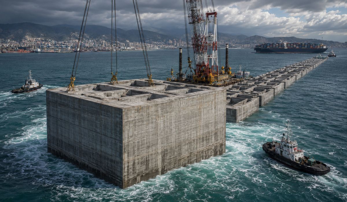
Italy Sinks Massive 11-Story Concrete Structures in the Ligurian Sea to Create a 6.2 km Barrier, Clearing the Way for 400-Meter Ships in Genoa


In addition to the city in the Western Border region, the storm spread its effects across different areas of Rio Grande do Sul and showed how intense rain, when combined with strong winds and already saturated soil, can quickly increase the risk of damage, disruptions, and new associated events, such as landslides, hail, and fallen trees.
The numbers that explain the strength of the storm in the state
The data collected by authorities helps to gauge the scale of the occurrence. There were 19 municipalities affected in different regions of Rio Grande do Sul, over 500 displaced people, 225 houses flooded in a single city, and accumulations of up to 324 mm in just a few hours.
The scenario also included wind gusts above 80 km/h in some municipalities, in addition to rainfall exceeding 200 mm in at least three cities: São Gabriel, Caçapava do Sul, and Vila Nova do Sul. In the capital, Porto Alegre, the volume surpassed 100 mm in 24 hours in neighborhoods such as Guarujá and Lami.
Rosário do Sul concentrated the most severe situation in the state
Rosário do Sul was the most affected municipality on the damage map so far. The volume of 324 mm in seven hours caused widespread flooding, affected 225 residences, and displaced 512 people, making the city the main symbol of the storm’s strength in the state.
The severity led the Civil Defense to send teams to the municipality to assess the possibility of declaring a state of emergency. Even with the scale of the impact, there has been no need to open public shelters so far, as the displaced people were accommodated by family and acquaintances.
Deaths under investigation and search for missing persons heighten concern
Authorities are investigating two deaths that may be related to the storm. One involves a 24-year-old man, who was reportedly hit by an electric shock in Canguçu. The other is a 25-year-old woman, hit by a falling eucalyptus tree in the rural area of Bom Retiro do Sul.
Additionally, there are searches for three missing fishermen in the Pelotas region. This situation heightens the tension surrounding the episode and shows that the storm’s impact was not limited to material damage or urban disruptions, but also extended to situations of direct human risk.
Other cities reported floods, hail, and families out of their homes
Outside Rosário do Sul, the advance of intense rain was also felt in several other parts of the state. In São Gabriel, 21 families left their homes. There were floods in Santa Maria, Uruguaiana, Encruzilhada do Sul, and Alegrete.
In Nova Palma and Júlio de Castilhos, episodes of hail were recorded, showing that the storm had varied behavior depending on the region. This dispersion of damage reinforces that the event was not localized, but rather a widespread episode, with impacts in different parts of Rio Grande do Sul.
Porto Alegre also entered the path of intense rain
In the capital of Rio Grande do Sul, rainfall exceeded 100 mm in 24 hours in neighborhoods such as Guarujá and Lami. The municipal Civil Defense recorded at least 14 occurrences, including flooding on roads, roof damage, and a tree falling on a residence in the Vila Nova neighborhood.
Despite the disruptions, no injuries were reported in Porto Alegre. Still, the case shows that the storm not only affected inland cities but also pressured the capital’s urban infrastructure, with impacts on traffic, safety, and residents’ daily lives.
Affected highways show that the storm also compromised mobility
The impact was not restricted to urban areas. The rain also compromised state and federal roads, hindering travel on important stretches. **RS-348** was **fully blocked between Faxinal do Soturno and Ivorá** after the rise of **Arroio Guarda-Mor** destroyed a temporary detour.
In another section of the same highway, between **Faxinal do Soturno and Dona Francisca**, the asphalt gave way and required a **stop-and-go** operation. **BR-290** was **completely closed at km 353**, between **Vila Nova do Sul and São Gabriel**, due to the rise of **Arroio Bossoroca**, being reopened only during the early hours of this Saturday.
What keeps the state on alert even after the rain loses strength
Although the rain lost intensity this Saturday morning, the risk has not disappeared. The **Civil Defense of Rio Grande do Sul** maintains an **alert for moderate risk of landslides**, especially in hillside areas. The warning affects cities such as **Caxias do Sul, Muçum, Parobé, and Três Coroas**, valid until the early hours of Sunday, May 3.
Before that, on Friday, the **National Institute of Meteorology** had issued a **red alert for great danger** for storms in almost the entire state, with a forecast of **rainfall above 100 mm per day, winds exceeding 100 km/h, and the possibility of hail**. The institute also warned of **flooding, structural damage, fallen trees, and power outages**.
What changes for the population as the risk continues
Given the ongoing alert, the guidelines remain clear. Authorities recommend that the population **avoid flooded areas and hillsides**, **unplug electrical appliances in case of instability**, and seek **safe shelter during storms**.
In emergency situations, the indicated contacts are the **Civil Defense, at number 199**, and the **Fire Department, at number 193**. As there is still a forecast of **new isolated storms throughout the weekend**, monitoring remains crucial to reduce risks and accelerate responses.
Why this storm requires attention even after the peak of the rain
The episode makes it clear that the problem does not end when the volume of rain decreases. After the peak of the **storm**, the accumulated effects on soil, rivers, hillsides, roads, and urban structures remain, which prolongs the risk and increases the need for vigilance.
In Rio Grande do Sul, the sum of **flooding, strong winds, hail, damage to highways, investigation of deaths, and search for missing persons** shows that the impact went far beyond a momentary change in weather. The state remains under attention because the event opened a sequence of threats that can still evolve in the coming hours.
With the rain losing strength, but the risk of landslides and new storms still open, has the worst already passed in Rio Grande do Sul, or can the state still face new surprises in the coming hours?