
 Portuguese
  Spanish
Aerial images reveal a rare contrast in the Linguado Channel, where the closure made decades ago changed the water circulation, favored sediment accumulation, and returned to debate with the duplication of BR-280 and the proposal for partial reopening of the section.
Aerial images taken in the Linguado Channel, on the North Coast of Santa Catarina, highlight the difference in the appearance of the water between the two sides of the embankment through which the BR-280 and the railway access to São Francisco do Sul pass.
Closed since 1935, the section returned to the center of discussions because the duplication of the highway reignited the proposal for partial reopening of the channel, a measure associated with the recovery of water circulation in the Babitonga Bay region.
In the crossing, the planned solution includes the opening of a 100-meter span in the embankment and the construction of a new road bridge, with eight meters of free height to allow navigation.
-
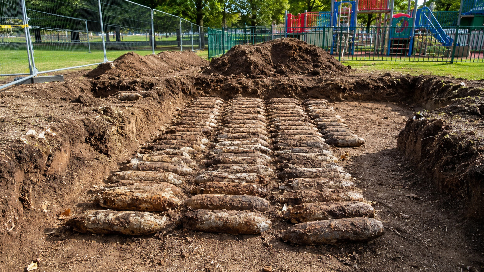
Workers renovating a playground in northern England uncover 176 World War II bombs buried underground; training artifacts still contained explosives.

-
Brazilian Architect Transforms Waste into Sustainable Homes with Solar Power and Rainwater Systems for 40 Years

-
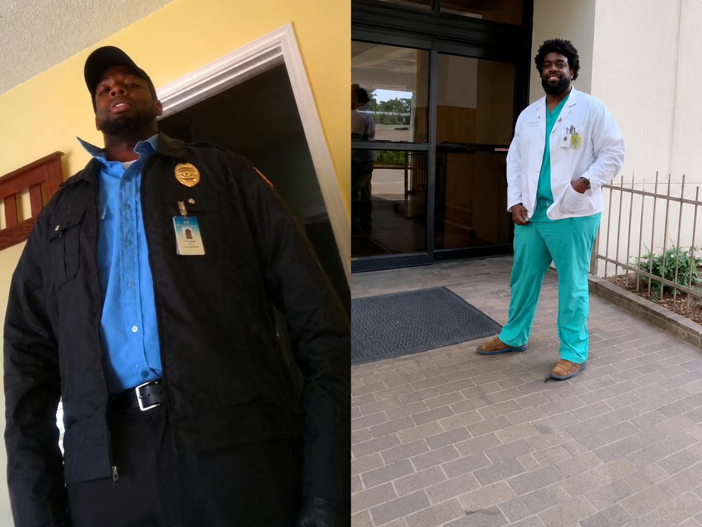
Security Guard Becomes Doctor at Louisiana Hospital Where He Once Worked, Studied Chemistry Between Shifts

-
Woman Rescued from Luxury Complex in Brazil Worked Without Pay for 55 Years, May Be Entitled to Over $300,000

The measure follows a recommendation from the Federal Public Ministry, accepted by DNIT, and is supported by technical studies on Babitonga Bay, an area directly influenced by the circulation changes caused by the channel closure.
With this change, the duplication of BR-280 could advance without preventing a future recomposition of water flow, a point considered central in discussions about infrastructure, navigation, fishing, and environmental quality.
According to the MPF, the project must include a bridge with four traffic lanes, passage over 100 meters of the embankment, and a central span capable of allowing the navigation of vessels up to 50 feet.

Despite the progress in the proposal, the effective removal of part of the embankment still depends on environmental licensing, resource definition, alignment between involved agencies, and a solution for the railway that also crosses the area of the former channel.
Embankment changed the circulation of Babitonga Bay
Before the closure, the Linguado Channel was part of the natural connection between Babitonga Bay and the Barra do Sul region, allowing greater water exchange between areas now separated by the embankment.
With the advancement of railway works at the beginning of the 20th century, the passage was reduced from approximately a thousand meters to about 120 meters, a section that came to be crossed by a swing bridge.
Designed to maintain local circulation, the metal structure allowed the passage of vessels and preserved part of the water flow between the two sides of the canal during the first decades of operation.
In the 1930s, however, the blockade was completed by order of the federal government, transforming the Island of São Francisco do Sul into a peninsula and consolidating a permanent physical change in the landscape.
The definitive closure occurred in 1935 and fixed the landfill used by the railway and, later, by the current BR-280, a road axis that today connects the port region to the mainland.
Since then, the interruption of the natural current has been associated with changes in the hydrodynamics of Babitonga, especially in the renewal of water and the accumulation of sediments in areas close to the blockade.
In aerial images, the contrast is striking because the water appears with different color and aspect on each side of the landfill, while low-movement points concentrate material deposited over the decades.
Historic bridge marked the connection with the port
Long before the complete blockade, the region was already used for transporting goods that arrived by sea and went to cities in Santa Catarina, in a dynamic linked to the port and local navigation.
In 1906, the construction of the railway began, a work associated with the connection between the mainland and the Port of São Francisco do Sul, during a period of logistical expansion in Northern Santa Catarina.
Murilo de Oliveira, director of Heritage at the Cultural Foundation and the Historical Museum Mayor José Schmidt, states that the railway advanced after the clearing of the forest and the arrival of the English company responsible for the concession.

Upon encountering the canal, the company designed a metal bridge to maintain the passage of vessels, preventing the railway work from completely interrupting navigation at that point in Babitonga Bay.
“When they came across the Linguado Channel, they designed a 140-meter bridge, with three spans of 40 meters, with the two ends fixed and the central span rotating to allow vessels to pass,” detailed Murilo.
Although inaugurated at the beginning of the 20th century, the iron bridges began to show signs of wear in the following decades, mainly due to the deterioration of the metal structure exposed to the weather.
According to Murilo, rust and the weakening of the bridge compromised the passage of trains, which led the federal government to opt for landfilling as an alternative to maintain railway circulation.
“The bridge, starting in 1930, began to show signs of deterioration, rust, and consequently, with the weakened bridge, it would not allow the passage of trains. So, the Federal Government decided to fill in the Linguado Channel,” he explained.
Reopening of the Linguado Channel divides residents and researchers
The proposal for partial reopening divides residents, fishermen, researchers, and public agencies because it involves environmental impacts, continuity of fishing, navigation safety, and infrastructure works on BR-280.
In Balneário Barra do Sul, where fishing plays a significant role in the local economy, part of the community fears that the movement of sediments accumulated at the bottom of the channel will affect the water and fishing activity.
The municipal secretary of Fishing, Sérgio Dias, stated that the concern is linked to the future of families who depend directly on the sea, especially in a community marked by generations of fishermen.
According to him, the fish from the region are currently considered healthy, and any change in the fill needs to be carefully analyzed before an intervention capable of stirring up old sediments.
“My biggest concern, as a fisherman, is what this will bring as a consequence for us in the future. Because I am the fourth generation. My grandfather, my father, myself, and now my son depend on fishing,” stated Sérgio.
Among researchers studying the Babitonga Bay, the assessment is different, as the partial reopening is seen as a measure capable of bringing environmental gains in the medium and long term.

Professor Claudio Tureck, from Univille and a member of the Pró-Babitonga Group, states that surveys conducted since 2018 analyzed deep sediments, possible contamination by heavy metals, and water behavior in the area.
These studies were presented to DNIT and served as one of the technical bases for the partial opening proposal, precisely because they gather data on sediments, water circulation, and environmental quality.
In a scientific publication from 2024, researchers analyzed metals in sediments from Babitonga Bay and indicated that the observed concentrations were below the level 1 values defined by Conama Resolution 454/2012.
“We believe that reopening the Linguado Channel can be beneficial for the Babitonga and increase fishing productivity,” stated Claudio Tureck.
BR-280 project depends on licensing and studies
The current discussion goes beyond the duplication of BR-280 because the crossing of the Linguado Channel brings together interests of infrastructure, logistics, environment, fishing, and navigation in a strategic area of the Northern Coast of Santa Catarina.
By connecting the port area to the mainland and concentrating a heavy flow of cargo vehicles, the highway has become a central piece in the debate on how to reconcile mobility, economic activity, and environmental recovery.
In the new project for lot 1 of BR-280, between Araquari and São Francisco do Sul, the analysis of a bridge over the canal has been included in the redesign of the work.
According to information published in April 2026, DNIT approved the bidding for the project contract, with an estimated deadline of 19 months for the completion of studies and technical definitions.
The proposal under discussion foresees the removal of about 100 meters of embankment and the installation of road and rail structures, a step considered necessary to make the work compatible with the partial reopening.
It was also pointed out the need to remove approximately 530 thousand cubic meters of sediments accumulated over the decades, a procedure that requires specific environmental assessment before any intervention.
So far, the road bridge appears as the most advanced step within the redesign of the BR-280 project, while the recovery of the water passage remains conditioned to complementary studies and licensing.
The effective opening of the canal still depends on the definition of responsibilities between DNIT, environmental agencies, the Federal Public Ministry, and other entities involved in the work, in the supervision and in the environmental stages of the project.


