 Portuguese
  English
  Spanish
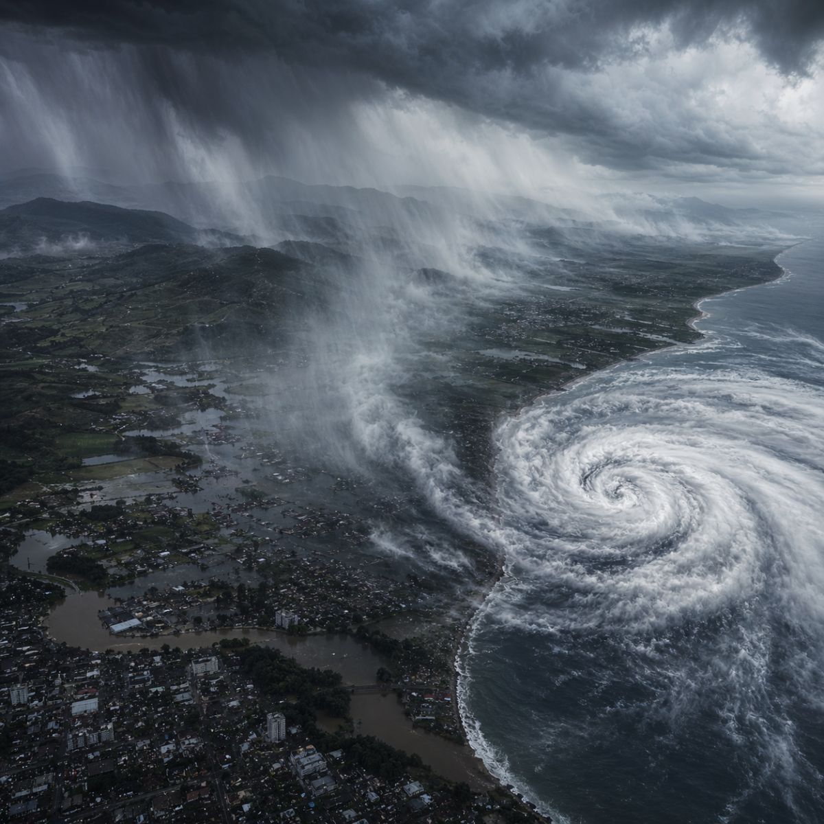
A new extratropical cyclone formed over the Atlantic Ocean is advancing through southern Brazil, causing storms, frequent rain, and winds with gusts of up to 80 km/h in Rio Grande do Sul and Santa Catarina. Climatempo points to Thursday (23) as the most critical day of the week, with an intense cold front, a drop in temperature, and a humidity corridor extending to Paraguay.
The cyclone that formed over the ocean is already imposing a week of unstable weather in southern Brazil. The system’s activity began on Monday (20) with the formation of a trough in the interior of Rio Grande do Sul, affecting mainly the western half of the state, including regions such as Campanha, Fronteira Oeste, and Missões. Starting Tuesday (21), the intensification of meteorological conditions expanded the areas of instability, and in the Extreme West and West of Santa Catarina, rain began in the early hours of the morning.
The cyclone works in conjunction with the advance of a cold front, which enhances the occurrence of rain in different points of both states during the Tiradentes holiday. Wind gusts can reach 80 km/h, especially in the south, east, and coastal areas of Rio Grande do Sul. The system is expected to lose strength upon reaching the height of Santa Catarina, already moving toward the Atlantic Ocean, which limits the direct impact on other regions of the country. Nevertheless, the combination of cold front, high humidity, and wind maintains a scenario that requires attention, especially in areas with a history of high rain accumulation.
How the extratropical cyclone influences the weather in southern Brazil
According to information released by the ndmais portal, the mechanism behind the instability is clear. The cyclone forms over the ocean and acts as a engine that pulls humidity and injects it over the continent, while the cold front associated with the system advances from southwest to northeast, sweeping through Rio Grande do Sul and reaching Santa Catarina. This combination creates favorable conditions for persistent rain, with volumes that can be significant in a short period of time.
-
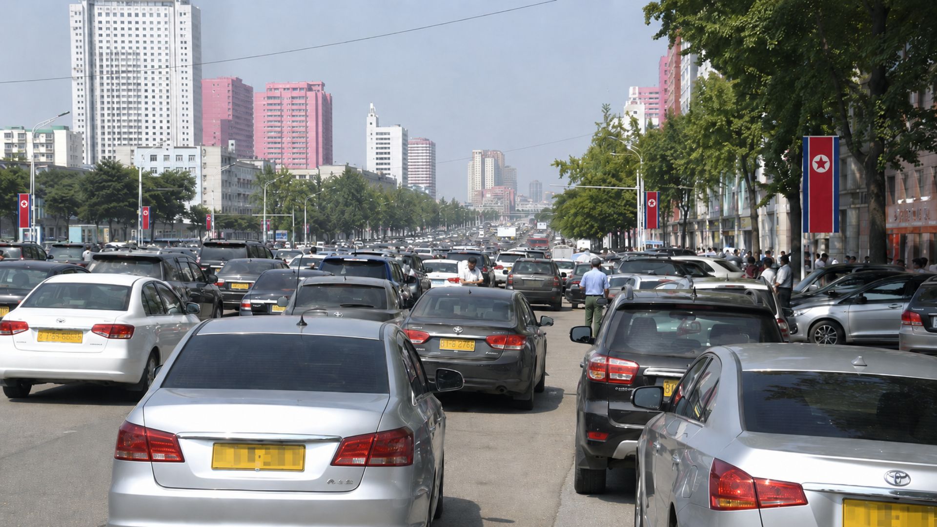
North Korea faces traffic jams for the first time in history, and residents of Pyongyang are already having difficulty parking, with yellow license plates of private cars everywhere and analysts estimating that the number of private vehicles could exceed 20,000 next year.

-
From the Moon to the construction site: NASA’s 3D printing technology now erects buildings on Earth with record speed and zero waste
-
Mysterious green rocks found in a remote cave in Spain may reveal that prehistoric peoples climbed the Pyrenees to work with copper thousands of years ago.
-
Crisis at Samsung heats up in South Korea and threatens to turn a bonus dispute into a global headache for the semiconductor market


Wind gusts are another direct effect of the cyclone. The difference in atmospheric pressure between the center of the system and the continental areas accelerates the movement of air, generating strong winds that increase the feeling of instability and can cause damage in urban areas, such as falling trees and roof damage. The coastal region of Rio Grande do Sul is the most exposed to the gusts, which can exceed 80 km/h at the moments of greatest intensity of the system.
What to expect on Wednesday and why Thursday will be the most dangerous day
On Wednesday (22), the cyclone will already be consolidated offshore, but its influence over the state of Rio Grande do Sul remains strong. The air fronts advance and heavy rains may affect a large part of the state, with volumes that require special attention from residents in hillside and floodplain areas. The moisture carried by the system fuels the formation of heavy clouds that regenerate throughout the day.
Thursday (23) is pointed out by meteorologists as the most critical day of the week. The cold front advances with maximum strength, causing a sharp drop in temperature in the Serra Gaúcha and in areas of Santa Catarina, and organizes a corridor of moisture that extends to Paraguay. This corridor acts as a channel that transports water vapor for hundreds of kilometers, keeping the rain active over a wide area of the territory. The change in weather will be noticeable not only by the precipitation but also by the cold that accompanies the passage of the cold front.
The impacts that the cyclone can cause in the most vulnerable regions
Regions with a history of high rain accumulations are the ones that need the most attention this week. Rio Grande do Sul carries the recent memory of the floods of May 2024, and any weather system that brings significant precipitation volumes raises alarms among authorities and the population. Although the current cyclone has a more defined trajectory toward the ocean, which reduces the intensity of impacts compared to previous episodes, the combination of persistent rain and strong wind should not be underestimated.
Hillside areas, riverbanks, and urban regions with poor drainage are the most vulnerable points. The authorities recommend avoiding unnecessary travel during peak rain and wind, especially between Wednesday and Thursday, when the system reaches its most active phase over the state of Rio Grande do Sul. Santa Catarina is also expected to register rain along the coast and in areas near the border with Rio Grande do Sul, although with less intensity.
What happens after the passage of the cyclone and how the weekend will be
Even on Friday (24), the remnants of the system will still be affecting the coast of Santa Catarina and the coastline of Rio Grande do Sul. The atmospheric instability does not disappear immediately, and isolated rains may occur in these areas before the weather begins to stabilize more consistently. The cold front will have already advanced to lower latitudes, but the residual moisture keeps the sky overcast along the coastal strips.
The trend for the weekend is for gradual improvement, with sunshine and a decrease in accumulated precipitation. The cold, however, is expected to remain, as the polar air mass accompanying the cyclone tends to keep temperatures low for several days after the system passes. For those living in the South, the recommendation is to follow updates from meteorological agencies and prepare for a week where instability will be the rule, not the exception.
Are you in the area affected by this cyclone? How is the weather in your city? Share in the comments if the rain and wind have already reached your region; your information can help other readers prepare for what is still to come.


Be the first to react!