 Portuguese
  English
  Spanish
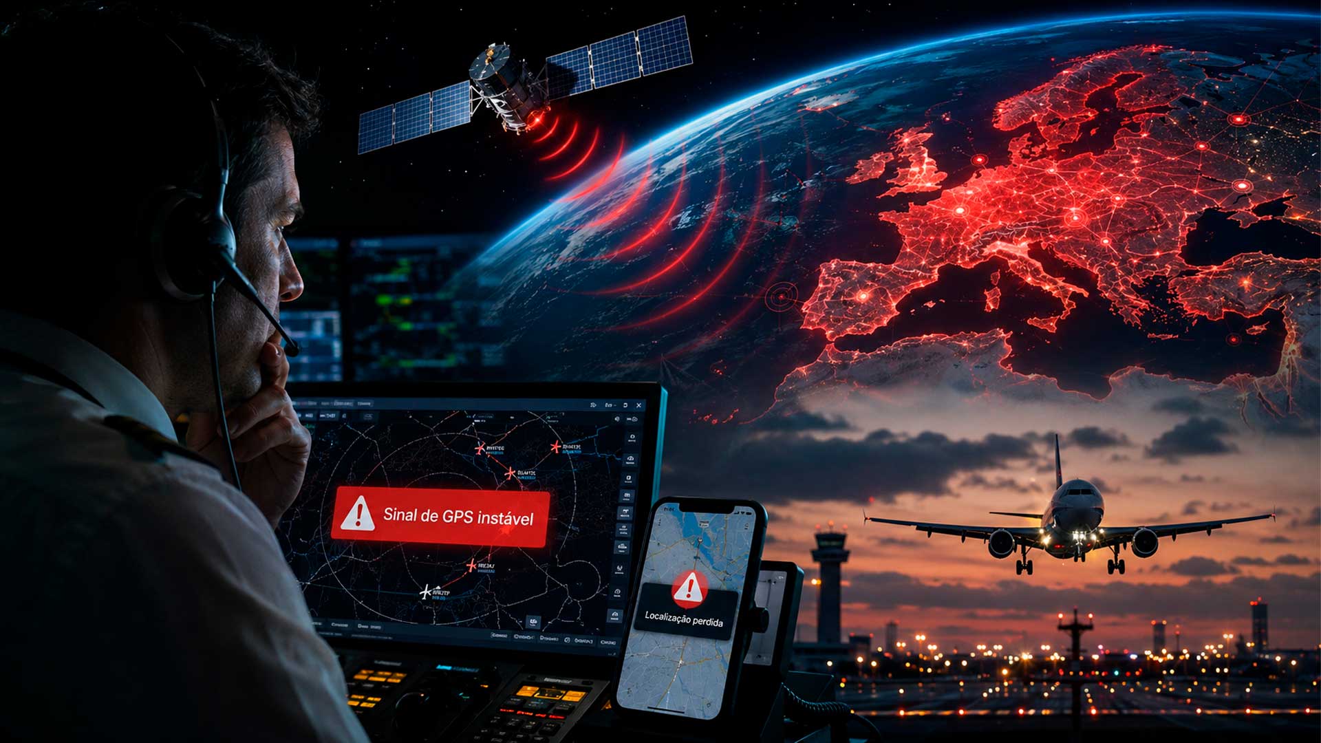
Researchers identified a rare pattern of interference in satellite navigation signals since 2019, but still treat the origin as a technical hypothesis that requires more data
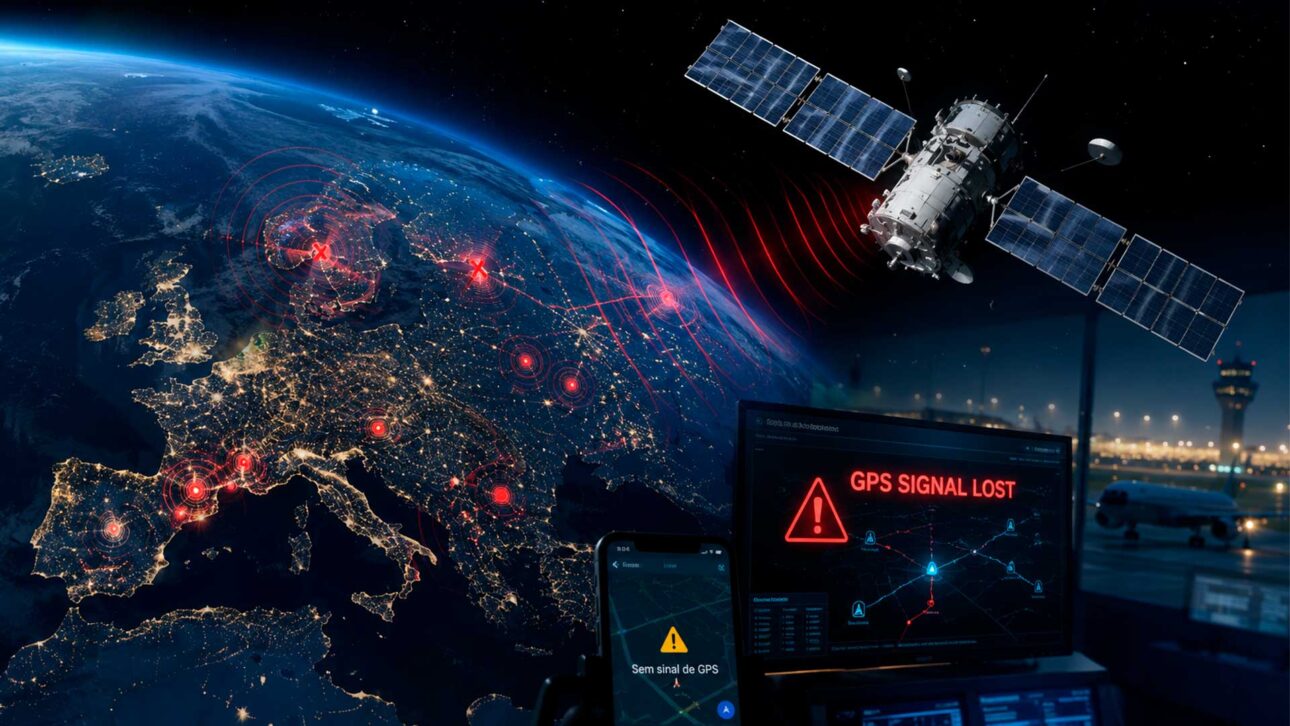
Mysterious GPS signal failures detected on a large scale in Europe, Greenland, and Canada have once again raised the alarm about the safety of satellite navigation systems. A recent study by researchers from the University of Texas at Austin and Stanford University suggests that the likely origin of these interferences may be in Russian early warning satellites, used to monitor missile launches.
The investigation, released in June 2026 in a scientific pre-publication format, analyzed data collected between 2019 and 2026 by GNSS ground stations, an acronym used for global satellite navigation systems, such as GPS, Galileo, GLONASS, and BeiDou. According to PCGuia, the episodes drew attention because they lasted only a few seconds but were perceived simultaneously by receivers spread over very large areas.
The central point is that the researchers are not just talking about ground blockers near borders or war zones, something already known in Europe since the beginning of the war in Ukraine. The study suggests a more sensitive possibility: interference originating in space, capable of affecting large regions at once.
-
All it took was the radio on, a cake with generous frosting, and a house full of aunts and neighbors for any birthday to turn into a celebration; childhood parties marked entire generations precisely because they needed almost nothing.

-
Hyundai took four Spot robot dogs to the 2026 World Cup, which will patrol, inspect, and monitor crowds at tournament venues in the United States, marking the debut of this type of robot at a World Cup.
-
Two rivers that emptied into the Mediterranean 5 million years ago were diverted by the birth of entire mountains and joined to form the Euphrates; the cradle of Mesopotamia was born from a twist that took the Earth millions of years to complete.
-
12-year-old boy makes handmade rosaries with seeds grown at home and delivers them to hospitals to bring faith, care, and hope to hospitalized children.


Study points to rare GPS interference in Europe since 2019
According to the study “Chasing Lightning”, authored by Zachary L. Clements, Argyris Kriezis, and Todd E. Humphreys, transient and wide-ranging events were identified that affected GNSS signals over continental Europe, Greenland, and Canada since 2019. The analysis was based on measurements of power received by ground stations and on time difference of arrival methods of the signal.
PCGuia reported that, between January 2019 and April 2026, the researchers found 75 days with at least one widespread interference event over the GPS L1 band, frequency of 1575.42 MHz, one of the most important for civil navigation.
These episodes, according to the publication, lasted less than ten seconds but appeared simultaneously in very distant stations.
The pattern also drew attention for its temporal behavior. As reported by specialized coverage, the anomalies appeared more frequently on Tuesdays, Wednesdays, and Thursdays, during European business hours, which reinforced the suspicion of an artificial and recurring source.
Even so, the researchers are treating the case with caution. The work was submitted for review in the journal NAVIGATION, of the Institute of Navigation, but still appears as a pre-publication. This means that the results are relevant, but still need to undergo the formal scientific review process.
Why Russian satellites came under investigation radar
The suspicion about Russian satellites arose after the authors cross-referenced the interference times with the position of satellites above the horizon at the time of the events.
The analysis narrowed down the possible culprits to a group of Russian satellites in Molniya orbits, used by systems that remain visible over high latitudes for long periods.
According to the study, the most likely source would be linked to the Russian early warning constellation known as EKS, or Edinaya Kosmicheskaya Sistema. This type of system’s main function is to detect ballistic missile launches, not block GPS, which makes the hypothesis even more delicate and technically controversial.
A report from TechRadar, based on the study and coverage by Ars Technica, cited that an event in February 2026 was traced back to the satellite Kosmos 2546. The same coverage highlighted, however, that experts are still debating whether the interference was deliberate, accidental, or a consequence of some secondary system function.
This caution is important because there is, so far, no definitive public confirmation of authorship or intent.
PCGuia itself noted that, for irrefutable proof, it would be necessary to capture raw data of the radio signal emitted by the interference source, something that the GNSS receivers used in ground stations cannot provide alone.
GPS blocking and spoofing affect airplanes, ships, and urban services
The topic is sensitive because GPS is not just for opening maps on a cell phone. According to GPS.gov, the official service of the United States government, the system provides precise positioning, navigation, and timing, used by communications, power grids, banks, financial markets, logistics, agriculture, mining, and transportation.
In practice, a GPS failure can cause anything from a momentary loss of location in apps to problems in navigation systems of aircraft, drones, ships, and infrastructures that depend on time synchronization. In civilian environments, the greater risk is not the cell phone “getting lost” for a few seconds, but the repetition of these events in critical areas.

The European Union Aviation Safety Agency, EASA, states that GNSS interferences have notably increased since February 2022, mainly near conflict zones and sensitive areas such as the Baltic Sea, Black Sea, Mediterranean, Middle East, and Arctic. The agency differentiates two main problems: jamming, when the signal is blocked or degraded, and spoofing, when false signals deceive the receiver and generate incorrect location.
According to EASA, these episodes can cause position discrepancies, false terrain system alerts, navigation deviations, and the need for flight redirection. The entity emphasizes that modern aircraft have alternative navigation means, but interference increases crew workload and requires well-coordinated procedures.
Europe has already adopted a plan to deal with GNSS interference
The concern was not limited to laboratories. In March 2026, EASA and EUROCONTROL published a joint plan to improve the safety of air operations during GNSS interference events.
The document proposes short, medium, and long-term actions to expand monitoring, data sharing, and guidance for pilots, controllers, and national authorities.
The European plan recognizes that interference in satellite navigation signals is no longer an isolated case and requires a coordinated response. Measures include creating a common operational vision, harmonized procedures, and the development of onboard equipment more resistant to signal failures or manipulations.
The pressure also appears in recent episodes in the Baltic. In May 2026, Reuters reported that Lithuanian authorities accused Russia of expanding its capacity to falsify GPS signals from Kaliningrad, a Russian enclave between Poland and Lithuania. According to the report, the estimated range could reach up to 450 kilometers, affecting parts of the Baltic countries, Poland, Finland, Sweden, and the Baltic Sea.
Moscow denies recurring accusations of electronic interference and attributes these allegations to Western campaigns. Nevertheless, European regulators, aviation companies, and monitoring services continue to record an increase in jamming and spoofing events in regions close to the conflict in Ukraine.
What changes if the interference comes from space
The biggest difference between a terrestrial jammer and a possible space source is the range. A ground jammer usually affects a limited region, although it can cause significant disruptions at airports, ports, borders, or urban centers. A source in orbit, however, would have the potential to reach continental areas, even if for short windows.
For this reason, the study gained attention. It does not claim that the global GPS is about to “fail,” nor that all users will be affected at the same time. The warning is different: if space systems can interfere with GNSS signals recurrently, the global dependence on satellite navigation becomes more vulnerable.
GPSJAM, a platform that publishes daily maps of GPS interference based on aircraft data, shows how these disturbances can be monitored on a global scale. The tool classifies areas by levels of interference and helps visualize regions where aircraft detect loss, degradation, or alteration of signal.
In Brazil, there is no indication that this specific case is affecting the daily functioning of GPS. Nevertheless, the discussion is of interest to the country because sectors such as aviation, maritime navigation, telecommunications, energy, precision agriculture, and logistics increasingly rely on GNSS to operate efficiently.
Dependence on GPS exposes security and infrastructure challenge
The case reinforces a lesson that governments and companies have already been discussing: critical systems cannot rely on a single source of location and time. For navigation security experts, the answer involves redundancy, using multiple GNSS constellations, inertial sensors, radio navigation, updated maps, and systems capable of detecting suspicious signals.
The United States Federal Aviation Administration, the FAA, also advises operators and pilots to treat GNSS interference as an emerging threat. In a technical guide on the subject, the agency explains that jamming can prevent the receiver from capturing legitimate signals, while spoofing can generate false and potentially confusing position, navigation, or timing.
For the common user, the practical recommendation is to understand that occasional GPS failures can have various causes, such as tall buildings, tunnels, space weather, device problems, or local interference. However, when the issue involves continental scale and repeated patterns, the analysis becomes a matter of national security, aviation, defense, and critical infrastructure.
The investigation into possible Russian satellites does not yet conclude the case but broadens the debate about the fragility of a technology present in virtually all sectors of the modern economy. GPS has become invisible in daily life precisely because it almost always works, but recent episodes show that this trust needs to be accompanied by protection, monitoring, and alternatives.


Be the first to react!