Portuguese
  Spanish
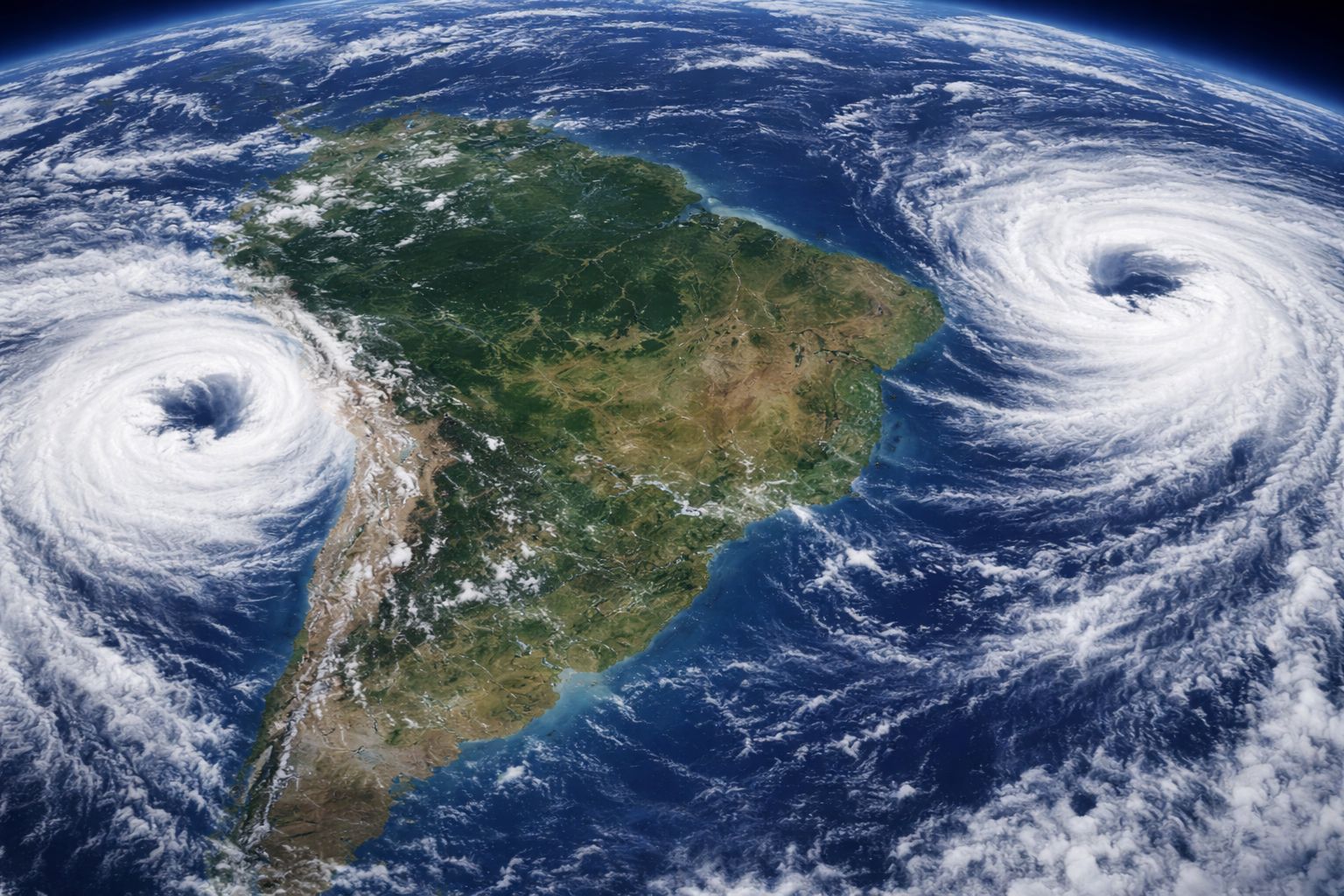
Two cyclones are operating simultaneously near Brazil this week. A system formed between Argentina, Paraguay, and Uruguay brings moderate to heavy rains to the South, while another cyclone in the Atlantic pushes a mass of cold air that drops temperatures by up to 6°C in areas like the Serra da Mantiqueira, affecting from the South to the Northeast.
Two cyclones are acting at the same time near Brazil and changing the weather in much of the country. The systems formed last Wednesday (15) and are expected to cause rain and a significant drop in temperature this Thursday (16). One of the cyclones formed over the continent, between Argentina, Paraguay, and Uruguay, and is already directly influencing the South of Brazil with moderate to heavy rainfall. The other is positioned in the Atlantic Ocean, far from the coast, but with powerful indirect influence: it maintains a mass of cold air that reaches from the South to part of the Northeast, dropping temperatures in high-altitude regions.
The combination of the two cyclones creates an unusual meteorological scenario where different parts of Brazil face distinct effects at the same time. In the South, the forecast for this Thursday includes a closed sky in the early morning and morning, with moderate to heavy rain showers and moderate wind gusts in Rio Grande do Sul, western Santa Catarina, and southwestern Paraná. In the Southeast and part of the Northeast, the second cyclone keeps temperatures lower, with minimums between 13°C and 16°C in the eastern South Region, potentially reaching around 6°C in higher altitude areas like the Serra da Mantiqueira.
What are cyclones and why are two operating together over Brazil
According to information from the portal ndmais, cyclones are areas of low atmospheric pressure that function as centers of wind circulation, favoring the formation of clouds and the transport of moisture and cold air. The intensity and extent of each system vary, but the practical effect is the same: they reorganize wind and temperature patterns over vast areas, potentially increasing cloudiness, altering wind directions, transporting cold air masses, and causing rain in regions that, without the presence of the cyclones, would have stable weather.
-
In Andradina, in the interior of SP, a tannery transformed tilapia skin that slaughterhouses used to throw away into exotic leather for bags, shoes, and even wedding dresses, producing about 2,000 pieces per month and exporting to seven countries, proving that fish waste has become high-value fashion.

-
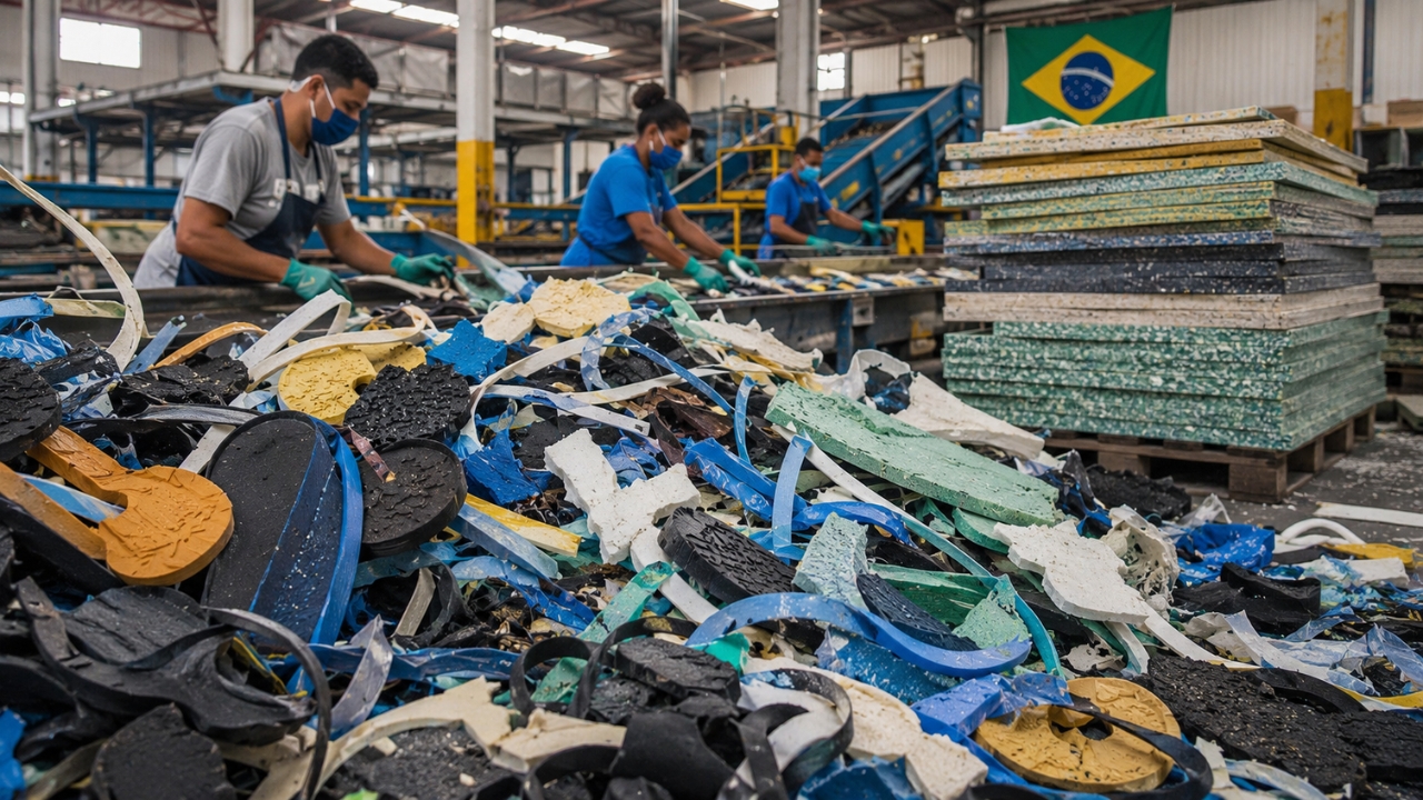
The industrial waste that even recyclers didn’t want has gained value in the interior of Bahia: two entrepreneurs invested R$ 2.8 million to transform 350 tons per year of foam, rubber, and plastic into boards that can replace wood and MDF.

-
What is a red flashlight used for, after all? See why it is so commonly used at night.

-
He has never read a line of code, but he already knows how to work: the French company UMA presented in Paris the Northstar, its first AI-powered humanoid robot designed for factories and warehouses, capable of copying tasks just by observing an employee in action.


The simultaneous operation of two cyclones near Brazil is not unprecedented, but it is relatively uncommon. Each system operates independently, with different origins and trajectories, but their effects combine over Brazilian territory, creating a scenario where some regions face intense rain while others deal with atypical cold for the season. According to information from Meteored, the two cyclones are expected to maintain influence over the country throughout this week, with intensity varying as they move.
Where the first cyclone causes heavy rain in Brazil
The cyclone formed on the continent, between Argentina, Paraguay, and Uruguay, is directly responsible for the instability in Southern Brazil. The forecast for this Thursday indicates moderate to heavy rain showers in Rio Grande do Sul, as well as areas in western Santa Catarina and southwestern Paraná, with a closed sky during the night and morning and gusts of wind that may cause disruptions in urban areas.
Throughout the afternoon, the trend is for a reduction in the rain caused by this cyclone, although there is still a possibility of light precipitation in isolated spots. Areas of Mato Grosso do Sul may also record occasional rains associated with the circulation of this system, which is gradually moving towards the ocean. In the coming days, the continental cyclone is expected to weaken as it moves away from Brazilian territory, reducing its direct influence over the South.
How the second cyclone drops temperatures by up to 6 degrees in the Southeast
The second weather system is located in the Atlantic Ocean, far from the Brazilian coast, but its indirect influence is felt in a band that extends from the South to part of the Northeast. This cyclone contributes to the maintenance of a cold air mass that has moved over the eastern part of Brazil, keeping temperatures lower than expected for mid-April in various regions.
The most intense effects of the two combined cyclones are felt in high-altitude areas. In the Serra da Mantiqueira, temperatures can drop to around 6°C, while on the coast of Santa Catarina, interior of São Paulo, much of Minas Gerais, the mountainous region of Rio de Janeiro, and the interior of Bahia, the minimums range between 13°C and 16°C. For those living in these regions, the early hours of the day require warm clothing, and the wind intensified by the cyclones can make the thermal sensation even lower.
What to expect in the coming days with the movement of the cyclones
The dynamics of the two cyclones will change throughout the week. The system formed on the continent tends to move towards the ocean in the coming days, gradually reducing its influence over Brazilian territory and decreasing rainfall in the South. This movement is expected and is part of the life cycle of extratropical cyclones, which form over land and migrate to the sea as they lose energy.
The cyclone positioned in the Atlantic, on the other hand, maintains its influence for a longer time. As long as it is active, it will continue to favor the entry of cold air over Brazil, keeping milder temperatures mainly in the early hours of the day in regions extending from the South to the Northeast. The expectation is that this second system will also weaken throughout the week, allowing temperatures to gradually return to normal patterns for the season. Until then, the two cyclones are responsible for the unstable and cold weather that marks this week in the country.
How to protect yourself from the effects of the cyclones hitting Brazil
For residents of the South, where the first cyclone brings heavy rain, the recommendations are practical. Avoid flood-prone areas, keep a distance from streams and rivers that may overflow, secure loose objects on balconies and yards that the wind may throw, and monitor alerts from Civil Defense are measures that reduce risks during rain showers with gusts of wind. In rural areas, attention should be doubled with dirt roads that may become impassable.
For those facing the cold brought by the second cyclone, the main focus is on respiratory health: temperatures of 6°C in mountainous areas require adequate clothing, constant hydration, and special care for the elderly, children, and people with chronic respiratory diseases who are more sensitive to sudden drops in temperature. The two cyclones are expected to lose influence over the next few days, but while they are active, the weather in Brazil remains under the control of these two meteorological machines that surround the country from different flanks.
Two cyclones surround Brazil at the same time: one brings heavy rain to the South and the other drops temperatures to 6°C in the Southeast. Did you feel the effects in your city? How is the weather there? Share in the comments.