
INMET issues orange alert for Paraná and Rio Grande do Sul with intense rain, hail risk and winds of up to 100 km/h, while a cold front advances through the South and drops temperatures to 0°C to 4°C in Rio Grande do Sul areas, bringing frost risk right after the holiday weekend storms.
According to Agência Brasil, the National Institute of Meteorology issued two orange-level warnings, a danger classification, this Saturday, May 2, valid for 24 hours for Paraná and Rio Grande do Sul. The alert covers the Serrana, Southwest, Southeast, West, and Central-South regions of Paraná, in addition to areas of Rio Grande do Sul, with forecasts of intense rain and strong winds. The forecast indicates accumulations that can reach 60 millimeters per day and, punctually, exceed 100 millimeters in Rio Grande do Sul, with winds between 60 and 100 kilometers per hour. On Sunday, May 3, the advance of the cold front should allow the entry of a dry and cold air mass through Rio Grande do Sul, dropping minimums to values between 0°C and 4°C.
The sequence is harsh: first intense rain, with risk of hail and gales; then polar cold, when the sky clears and temperatures plummet. It’s the worst of both worlds concentrated in a single holiday weekend.
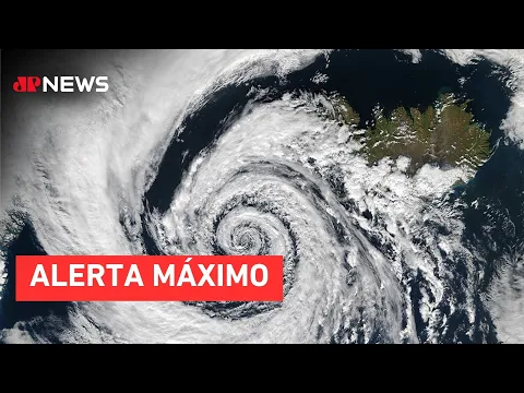
Cold front associated with extratropical cyclone reorganizes weather in Southern Brazil this weekend
The system that reorganizes the weather in Southern Brazil this weekend originates from a strong cold front, associated with an extratropical cyclone that began to organize over the Atlantic Ocean south of the continent. The system advanced through Rio Grande do Sul starting Friday, May 1st, at dawn.
-
James Webb Telescope Uncovers Unexpected Clues on Mysterious Moon, Potentially Redefining Planetary Origins

-
$1.5 Billion Sleipnir Vessel Transforms Ocean into Floating Construction Site with 12 Hybrid Engines and Capacity to Lift 20,000 Tons

-
23 Years After Tragedy, Brazil’s Alcântara Space Center to Launch New Suborbital Rocket in 2026 with South Korean SEBIT Project Targeting Near-Space Tests
-
Entrepreneur Turns Neighbor’s Coffee Grounds Waste into Eco-Friendly Pellets, Earning Up to $40,000 Monthly in Brazil


Climatempo classified the cold front as of strong intensity for this time of year, a technical definition that indicates a high contrast between the warm and humid air mass that dominated the South and the polar cold air mass that advanced behind the system. The greater this temperature difference, the more energy is available to produce intense rain, strong winds, and hail.
On Friday, the system reached Rio Grande do Sul with storms, heavy rain, lightning, and winds. Throughout Saturday, the front continued to advance with a gradual loss of intensity, but still with forecasts of moderate to heavy showers in central and western Santa Catarina, as well as areas in southern, eastern, and western Paraná.


