
 Portuguese
  Spanish
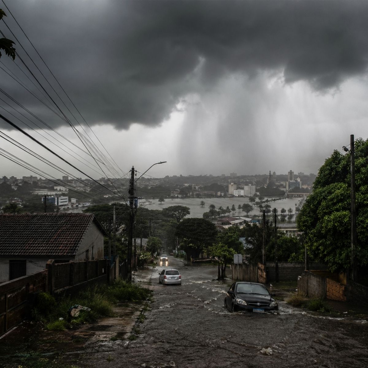
MetSul warns of voluminous rain of up to 200 mm in Rio Grande do Sul this long weekend, between Friday (1st) and Saturday (2nd), with a cold front formed by the interaction between high polar pressure and an extratropical cyclone, risk of floods, inundations, storms with hail and gales between the Valleys, Serra and Porto Alegre.
The Labor Day long weekend in Rio Grande do Sul begins with a warning of voluminous rain that could cause floods and inundations in various regions of the state. MetSul Meteorologia predicts that between Friday (1st) and Saturday (2nd), high to excessive volumes of rain will hit the Gaúcho territory, with accumulations in several localities expected to be between 50 mm and 100 mm, potentially reaching 150 mm in concentrated spots and up to 200 mm in isolated areas, precipitation that in less than 48 hours is equivalent to what some cities receive in an entire month. The instability is accompanied by a risk of isolated storms, hail, and gales that may especially affect the Northeast of the state, the Valleys, the Serra, Greater Porto Alegre, and the North Coast on Friday afternoon and evening.
The origin of the intense rain lies in the combination of two meteorological systems converging over Southern Brazil. A high-pressure center with cold air advances from the South Pacific to Chile and Patagonia between Friday and Saturday, while an intense extratropical cyclone in the South Atlantic pushes this cold air northward through Argentina, and the interaction between these systems organizes and intensifies a cold front over Rio Grande do Sul and northeastern Argentina. The result is an abrupt change in weather that turns the long weekend into a period of risk for those living in areas vulnerable to water accumulation and for those planning outdoor activities without checking the forecast.
Which regions will have more rain and at what times
The distribution of rain throughout the long weekend follows a pattern that shifts from the West to the East of the state. The weather changes already in the early morning and morning of Friday in the Western Half of Rio Grande do Sul, while in other regions the sun still appears with clouds for a few hours before cloudiness increases and rain spreads across almost all of Rio Grande do Sul by the end of the day. Friday is highlighted as the day of greatest risk in several regions, and those traveling on roads in the interior of the state should expect stretches with reduced visibility and flooded roadways throughout the afternoon and evening.
-
Egypt Discovers 18 Ancient Tombs with Gold Tongues, Unveiling Unusual Funeral Rituals and Amulets Believed to Give Voice to the Dead

-
Nigeria Dumps 120 Million Tons of Sand into Atlantic to Build Massive City with 8.4 km Sea Wall for Protection Against Ocean Waves and Erosion
-
German Engineer Developed Diesel Engine Running on Vegetable Oil Decades Before Electric Cars Became Popular; Can This Forgotten Idea Work in 2026?

-
James Webb Telescope Uncovers Unexpected Clues on Mysterious Moon, Potentially Redefining Planetary Origins


On Saturday (2nd), the rain will concentrate in the Northern Half of Rio Grande do Sul. The beginning of the day still brings instability to several Gaúcho regions, but from afternoon to night the weather improves in much of the state as the sun appears with clouds in many cities. However, sectors of the Northwest, North, and Northeast of the state, closer to Santa Catarina, may still register rain and drizzle throughout Saturday, extending the risk period for these regions that will remain under the influence of the cold front for longer.
What causes such intense rain in Rio Grande do Sul this long weekend
The atmospheric mechanics that generate this volume of rain involve a clash between air masses of opposing characteristics. The high-pressure center advancing through the Pacific brings cold, dry air of polar origin, while the cyclone in the Atlantic feeds the moisture current rising from the ocean towards the continent. When these systems meet over Rio Grande do Sul, the warm moisture that had been predominant collides with the cold air arriving from below, and the temperature difference between the layers rapidly forces the humid air upwards, generating dense clouds that discharge rain in concentrated volume.
The intensity of this process is what differentiates common rain from an event with flood risk. Accumulations of 100 mm to 200 mm in less than two days overload drainage systems and cause floods in urban areas designed for smaller volumes, and rivers that have already received rain in the previous week can overflow when additional precipitation exceeds the drainage capacity of the hydrographic basins. Rio Grande do Sul knows this scenario well: the floods that devastated the state in 2024 demonstrated that extreme rain events turn rivers into threats and streets into canals, and MetSul’s warning for this long weekend demands proportional attention.
The risk for Porto Alegre and the metropolitan region with the long weekend rain

Porto Alegre and the metropolitan region are within the risk perimeter of the rain alert. The instability in the Gaúcha capital and surrounding cities is expected to concentrate between Friday afternoon and night and the first half of Saturday, a period when heavy downpours can cause water accumulation in roads known for flooding when the volume of rain exceeds the capacity of the storm drain networks. The improvement arrives in the second half of Saturday with the advance of dry and colder air that dissipates the cloudiness.
The risk of isolated storms with gales makes attention even more necessary in the metropolitan region. Strong gusts can knock down trees, tear off signs, and cause roof damage, and the combination of intense rain and wind in a densely urbanized area like Porto Alegre multiplies the points of occurrence that Civil Defense and firefighters need to attend to simultaneously. The guidance for residents is to avoid sheltering under trees or fragile structures during storms and to keep a distance from poles and power lines that may fall with the gusts.
What the weather will be like on Sunday after Friday and Saturday’s rain
Sunday (3) marks the return of stability to Rio Grande do Sul. A mass of dry and cold high-pressure air begins to define the meteorological conditions and ensures the predominance of sun throughout the state, ending the rain and instability that the cold front brought in the previous two days. The cold air mass skirts the Gaúcha coast and provides a mild Sunday that starts and ends with cold, a scenario completely opposite to Friday’s and one that allows for the safe resumption of outdoor activities.
For those who planned the long weekend in Rio Grande do Sul, Sunday is the safest and most pleasant day. The sun predominates, rain is not part of the forecast, and cool temperatures create comfortable conditions for outings, especially in the Serra Gaúcha where the cold matches the landscape. The transition between the heavy rain of Friday and Saturday and the sun of Sunday is abrupt but welcome, and residents who faced two days of instability will be able to enjoy the last day of the long weekend with the tranquility that the beginning did not offer.
What to do to protect yourself from intense rain this long weekend
Preparation is the best defense against the risks that rain volumes between 100 mm and 200 mm represent. Residents of riverside areas and slopes should monitor river levels and be prepared to evacuate if authorities advise, and those living in historically flooded regions should move valuable belongings to elevated places before the rain begins on Friday. Drivers should avoid traveling on flooded roads because the depth of the water is not always visible, and a few centimeters are enough to sweep away a vehicle.
For those planning to travel during the long weekend in Rio Grande do Sul, the recommendation is to postpone the trip until Sunday when the weather will be stable. If traveling on Friday or Saturday is unavoidable, reducing speed, keeping headlights on, and maintaining a safe distance from the vehicle ahead are minimal measures that can prevent accidents in conditions of heavy rain and reduced visibility. The long weekend brings a real risk of floods and inundations caused by the cold front, and the difference between facing the situation safely or being caught by surprise lies in the decision to take the rain alert seriously.
And you, are you in Rio Grande do Sul? How do you plan to protect yourself from the rain this long weekend? Leave your opinion in the comments.


