
 Portuguese
  Spanish
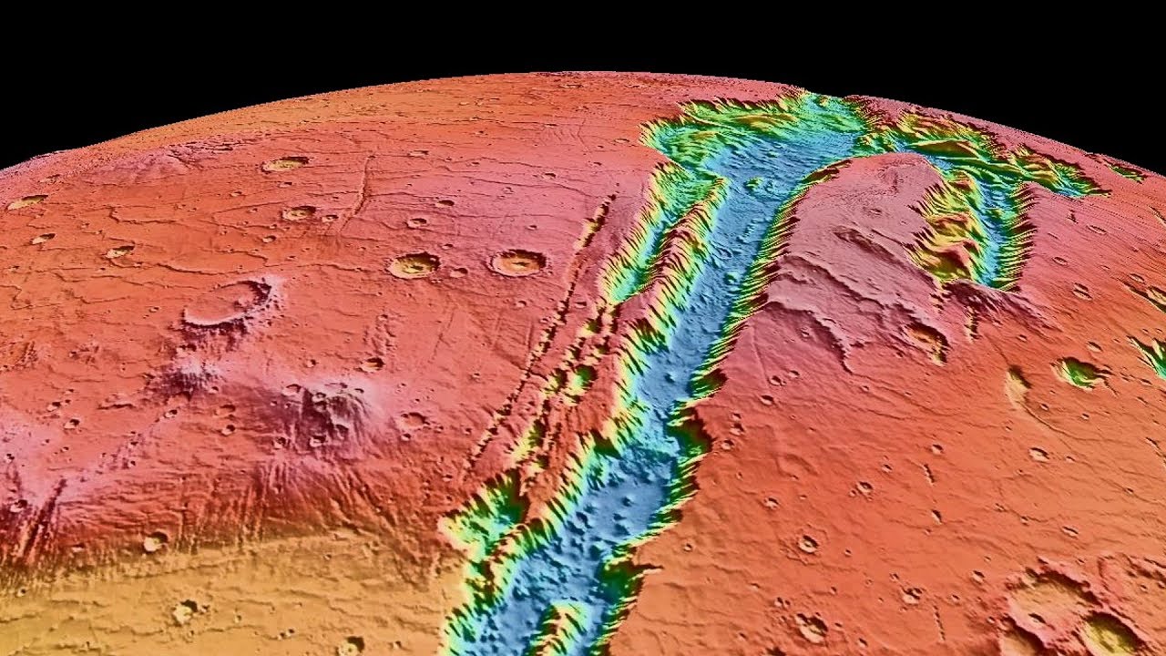
The Largest Canyon System in the Solar System Has 4,000 Km, Cliffs Up to 7 Km High, and Minerals Indicating Lasting Rivers and Lakes on Mars for Millions of Years.
In the Martian hemisphere, there is a scar so large that it defies any terrestrial reference. It stretches over 4,000 kilometers, reaches cliffs that exceed 7 kilometers in depth, and traverses the planet as if an entire continent had been torn apart. This structure is the Valles Marineris, the largest canyon system ever identified in the Solar System, increasingly recognized as a geological archive pointing to persistent liquid water on Mars over long intervals in the past.
For decades, the canyon was treated merely as an extreme tectonic phenomenon. Today, with data from orbiters, radars, and mineralogical analyses, the narrative has changed: there is consistent evidence of rivers, lakes, and collapses associated with water acting repeatedly over millions of years.
A Colossus That Rewrites Planetary Scales
Comparisons help to understand the scale of Valles Marineris. If it were placed on Earth, it would span an entire continent, surpassing the Grand Canyon in combined length and depth. Its segments include parallel trenches, steep escarpments, and internal basins capable of containing gigantic lakes.
-
China Overhauls Universities, Cuts 12,200 Outdated Courses to Focus on AI, Robotics, and Chips as 12.7 Million Young People Enter Workforce

-
Goodbye Wireless Earbuds: Gen Z Brings Back Wired Headphones as a Trend in 2026

-
Living Robots Made from Human Cells Crawl on Their Own in Lab, Help Heal Neuron “Wounds” and Turn Human Tissue into Microscopic Biological Machines
-
Xlinks Project to Lay 3,800 Kilometers of Cable Across the Atlantic to Export Solar Energy from Morocco Directly to UK Outlets Without Using a Single Turbine


The walls expose sedimentary layers like pages in a book: stacked deposits, eroded surfaces, and marks of ancient collapses. This stratigraphy is crucial because it records repeated processes, not an isolated event.
Why Tectonics Alone Does Not Explain Everything
Mars does not have moving tectonic plates like Earth. Still, Valles Marineris shows extensive fractures associated with the uplifting of the Tharsis region (where the largest volcanoes on the planet are located). This tension opened the ground, but opening is not sculpting.
Deep excavation and the geometry of many sections point to prolonged erosion, with material removed in large volumes. This is where the signs of water come in: inlet channels, sedimentary fans, thin-layered deposits, and hydrated minerals that only form in the presence of liquid water.
Minerals That Indicate Lasting Lakes
Spectral mappings revealed clays (phyllosilicates) and hydrated sulfates on the walls and the bottom of the canyon. Clays indicate water-rock interaction under relatively neutral conditions; sulfates point to evaporitic environments, such as lakes that dried up and refilled.
This set suggests stable bodies of water for long periods, not rapid runoff. In other words, the canyon would have housed internal lakes fed by regional drainages and possibly by pressurized subterranean aquifers.
Gigantic Collapses and Catastrophic Flows
Some segments exhibit marks of colossal landslides, with blocks the size of cities and surfaces “torn away.” These collapses are consistent with sudden release of groundwater when the ground support fails.
After the collapse, water would have flowed through deep channels, widening the canyon and redistributing sediments. The pattern resembles terrestrial megafloods, but on a planetary scale.
In addition to ancient surface rivers, evidence is growing that groundwater played a central role. On Mars, the cryosphere (permanently frozen soil) can trap water at depth. When geothermal heat, volcanism, or fractures allow for release, intense flows arise.
This mechanism explains why Valles Marineris exhibits concentrated erosion in certain sections and thick deposits in others, as well as temporal repetition of events.
Deep Time: Millions of Years of Activity
The major conceptual shift is temporal. The features do not align with a single episode. Overlapped layers and reworked surfaces indicate multiple cycles: water flowing, evaporating, returning. This pushes the history to millions of years, when Mars had a climate capable of intermittently supporting liquid water, but recurrently.

This scenario is compatible with a Mars less cold and less dry than previously thought, at least during prolonged climatic windows.
Habitability Potential: Where Water and Energy Meet
Where there is liquid water, reactive minerals, and energy (heat, chemical gradients), life finds opportunities. Valles Marineris brings together all three: ancient water, rock-water interaction, and possible hydrothermal sources associated with fractures and regional volcanism.
Even if life never arose there, the canyon preserves environments that would be habitable by terrestrial standards. That is why it has become a priority target for astrobiology.
Why the Canyon System Matters for Current and Future Missions
Orbiters continue refining mineral and structural maps. The next step involves selecting landing sites that maximize scientific return: access to ancient layers, lacustrine deposits, and fracture zones.
Exploring Valles Marineris is, in practice, exploring Mars’s water history — and testing hypotheses about when, how, and for how long water shaped the planet.
Today, the most accepted view is hybrid: tectonics opened, water sculpted, collapses enlarged. The result is a canyon that not only impresses with its size but documents Mars’s climatic transition.
Each new image adds details; each new mineral map fills gaps. Valles Marineris has ceased to be a “tear” and has become a continuous record.
What Remains to Be Discovered
There are still open questions: the exact duration of lakes, the connectivity between basins, the chemistry of water in different eras, and the role of ice. Answers will come with new missions, targeted sampling, and, in the future, human exploration.
Until then, the largest canyon in the Solar System continues to deliver silent clues that Mars was once a world where water worked with persistence.


Muito linda reportagem. Obrigada