

 Portuguese
  Spanish
A laser fired from a plane pierced the dense Bolivian jungle and revealed 21-meter pyramids hidden for 1,500 years.
Along with them, platforms the size of 30 football fields and a network of canals capable of feeding up to 100,000 people appeared.
The discovery, published in the Nature journal in 2022 and expanded by the German Archaeological Institute, forced archaeologists to rewrite what was known about the Bolivian Amazon before 1500.
-
Scientists claim to have created a way to “store solar energy” in a liquid molecule and release that heat when needed.

-
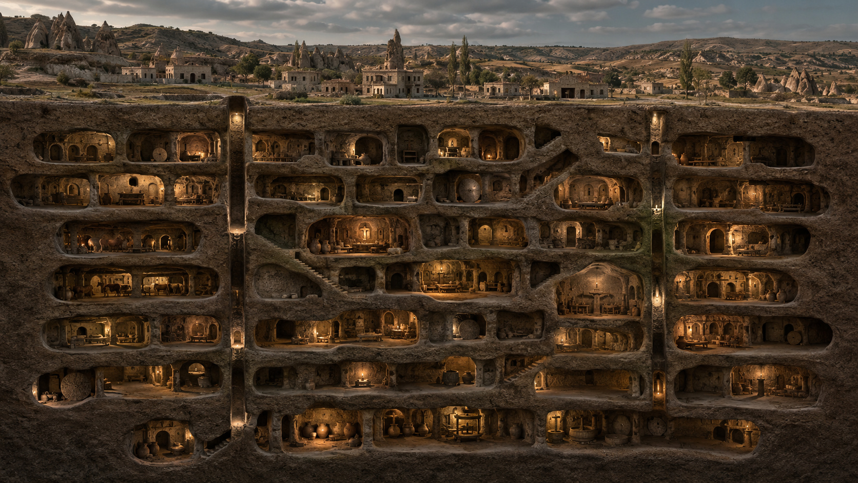
An 18-story human anthill was hidden 85 meters below Turkey: the underground city housed up to 20,000 people, had tunnels, rooms, passages, and ton-heavy stone doors, and was only rediscovered when a man broke a wall inside his own house.

-
Mother of 5 children started selling homemade pamonha door-to-door and today earns about R$ 250,000 per month with a factory that produces 1,500 units per day and sells to several Brazilian states.

-
NASA is advised to create a biocontainment facility on the Moon to prevent samples from Mars, the Moon, or other places in space from arriving directly on Earth with possible dangerous contaminants.


The civilization responsible for all this — the Casarabe Culture — was hidden under the vegetation for 1,500 years. And when the laser finally found it, the world discovered that the Amazon was never what it seemed.
How a laser scanner debunked the myth that the Amazon was a virgin and empty forest before 1500
For centuries, historians treated the pre-Columbian Amazon as a human void — inhabited only by small nomadic groups without urban structure.
It was a convenient argument. And it was completely wrong.
Archaeologist Heiko Prümers, from the German Archaeological Institute, and his team found in the Llanos de Moxos, in the Beni department of Bolivia, a radically different reality.
Under the closed canopy of the jungle, there were cities. There were roads. There were pyramids. There was also a hydraulic engineering system that allowed two corn harvests a year in the heart of the floodplain Amazon.
Therefore, the researchers used LiDAR — a system that fires billions of laser pulses from aircraft — and what appeared in the images left the team silent.

What the laser found under the Bolivian jungle
In 2019, Prümers and his team flew over the Llanos de Moxos aboard an aircraft equipped with LiDAR.
The equipment fired billions of laser pulses per second towards the ground. Each pulse passed through the tree canopies, bounced off the terrain, and returned to the sensor.
The software processed the difference between the returns and drew, in real-time, the ground relief — as if the forest simply did not exist.
What appeared was not the flat plain everyone expected. There were artificial mounds. There were platforms. There were carefully constructed embankments.
Moreover, there were elevated roads that started from one point and went straight for kilometers — without deviation, without hesitation — as if those who built them knew exactly where they were going.
The team identified a total of 26 settlements. Two of them were of extraordinary size: Cotoca, with 315 hectares, and Landívar, with 147 hectares. For comparison: the largest professional football field is just over 1 hectare.
Within these settlements, LiDAR revealed conical pyramids up to 21 meters high.
Thus, what lay beneath the jungle was not a village. It was an entire system of interconnected cities, completely invisible until that moment.

26 cities, 21-meter pyramids, and 10 km roads
The scale of what Prümers found is hard to absorb. The territory controlled by the Casarabe Culture covered approximately 5,020 km².
Just Cotoca, one of the large settlements, dominated an area of about 500 km² around, with connection infrastructure in all directions.
The roads were elevated relative to the surrounding terrain. This was no accident: in the floodplain of Moxos, the Amazon fills and empties in predictable cycles.
Building at ground level meant building underwater for months. Therefore, everything was erected above the flood line — and the connections between sites reached 10 kilometers in length.
In the largest sites, LiDAR data showed:
- Conical pyramids up to 21 meters high — equivalent to a 7-story building
- Artificial platforms with 5 meters of elevation, covering up to 22 hectares
- Civic-ceremonial structures in U-shape on the highest parts
- Elevated roads up to 10 km connecting the main urban centers
- Canals and reservoirs distributed throughout the inhabited area
Archaeologist Christopher Fisher, from Colorado State University, summarized the weight of the discovery: “The scale of the architectural remains at these sites is on par with any ancient society.”
Moreover, the hierarchical organization of the settlements — larger centers with smaller sites around — suggests centralized regional planning. It was no accident. It was governance.

The water system that made the impossible possible
The most impressive part of the Casarabe Culture is not the pyramids. It’s the canals.
A study published in the Nature journal in January 2025 revealed that the Casarabe developed a dual hydraulic system that solved two opposing problems at the same time.
During the rainy season, the Moxos plain floods completely. For this, the Casarabe built drainage canals that diverted excess water away from the cultivable areas.
Thus, while the surrounding plain was submerged, the Casarabe fields remained productive.
In the dry season, the problem reversed: the plain dried up quickly. For this scenario, the Casarabe built tanks and artificial ponds that retained moisture from the previous season.
The result of this dual system was extraordinary: two corn harvests per year, in the midst of the floodable Amazonian savanna.
Additionally, the reservoirs functioned as local temperature regulators, reducing the water stress of the crops during the most intense droughts.
Researchers identified at least three distinct types of hydraulic structures: drainage canals, retention tanks, and artificial ponds. Thus, the system operated in an integrated manner throughout the entire annual hydrological cycle.
While contemporary cultures in Europe and Asia struggled to ensure a single stable harvest, the Casarabe had systematic food surplus.
In this way, it was possible to sustain an estimated population of up to 100,000 people in a region that traditional archaeology considered incapable of feeding more than small semi-nomadic communities.

Who were the Casarabe — and how they disappeared
The Casarabe Culture existed for approximately 900 years, between 500 and 1400 Common Era.
This means that while the Roman Empire was collapsing in Europe, a complex civilization was thriving on the Bolivian plain — completely ignored by Western history.
The Casarabe were not nomads. They built permanently and planned on a regional scale. Their settlements had a clear hierarchy: larger centers with pyramids and civic-ceremonial structures, and smaller settlements connected by roads.
Thus, the Llanos de Moxos functioned as a complete urban system — with center, periphery, and connection infrastructure — centuries before any European explorer arrived in South America.
Around 1400, however, the Casarabe Culture disappeared. Researchers still do not have a definitive answer as to why.
Climate changes, conflicts with neighboring peoples, and collapse of the agricultural system are among the hypotheses. What is known is that when the Europeans arrived in the 16th century, they found no visible trace of this civilization.
The jungle had swallowed everything. Until the laser arrived, 600 years later, and returned what the forest had hidden.

The technology that made the discovery possible
LiDAR — an acronym for Light Detection and Ranging — works on a straightforward principle: an aircraft fires laser pulses toward the ground, with billions of shots per second.
Each pulse that hits a leaf bounces back to the sensor. Each pulse that passes through the branches and reaches the ground also bounces back — but with a slightly different return in time and intensity.
The software processes this difference and digitally separates the vegetation from the terrain below. The result is a three-dimensional map of the ground — as if the forest did not exist.
Therefore, what would take decades of field exploration can be done in hours of overflight. Structures invisible for generations are revealed in minutes.
Thus, archaeologist Prümers used LiDAR in the Llanos de Moxos — and the same system has already revealed up to 23,000 hidden structures under the Amazon in other regions.

Other civilizations the laser has already revealed
Casarabe is not an isolated case. In recent years, LiDAR has transformed the archaeology of tropical forests — and each new scan dismantles another piece of the “virgin forest” narrative.
In Ecuador, archaeologists found a network of 6,000 structures in the Upano Valley, revealing garden cities from 2,500 years ago. The complexity of urban planning found there is comparable to Mediterranean civilizations of the same period.
In Guatemala, a scan revealed 964 Mayan settlements, with elevated roads, plazas, and temples that researchers would take decades to locate manually.
On the other hand, the pattern is the same in all cases: the forest efficiently hid what humans built. And the laser is the first instrument capable of returning this record.
Moreover, each new discovery reinforces the same conclusion: tropical forests were not empty before Europeans. They were inhabited, managed, and transformed by civilizations that disappeared without leaving a visible trace on the surface.
What changes in the history of humanity
The discovery of Casarabe belongs to what archaeologists call “low-density tropical urbanism” — a model where the population is distributed over large territories, connected by infrastructure and supported by sophisticated agricultural systems.
Instead of dense centers like those in the Mediterranean, these civilizations occupied vast regions with lower concentration per area — but with equally complex organization.
The same pattern was identified in Angkor Wat, Cambodia, and in historical sites in Sri Lanka. Therefore, the Amazon was not a tropical exception — it was part of a global phenomenon of human organization still little understood.
Thus, when Prümers stated that “our results dismiss the arguments that western Amazon was sparsely populated in pre-Hispanic times”, he was describing a global revision — not just a Bolivian one.
However, the implication is not only historical. If a civilization of up to 100,000 inhabitants thrived in the Bolivian Amazon for 900 years without destroying the surrounding ecosystem, it raises questions about how the forest has been treated in recent centuries.
Eduardo Góes Neves, an archaeologist from USP and a specialist in pre-Columbian Amazon, summarized the significance of the work: “Heiko and Carla, to me, are the best field archaeologists in the Amazon today, and this work crowns their effort.”

And Brazil? What might be hidden in our Amazon
Bolivia does not have the monopoly on hidden civilizations. On the other side of the border, in the Brazilian Amazon, evidence of complex pre-Columbian occupations is also accumulating.
In Acre, the geoglyphs — geometric shapes carved into the ground, visible only from above — cover hundreds of square kilometers. Researchers believe that what the geoglyphs reveal is just the surface of a much larger organization.
Furthermore, the presence of identified paleoindigenous roads in Mato Grosso and Amazonas indicates that intercommunity connection networks existed in the Brazilian Amazon long before European contact.
Just as the Casarabe connected their settlements with elevated roads in Bolivia, peoples of the Brazilian Amazon built movement corridors that crossed hundreds of kilometers of forest.
Similarly, regions of Amazonas, Pará, and Mato Grosso present anthropic dark earth — soil modified by prolonged human occupation — in areas far from any recorded settlement.
Thus, the most conservative estimate of what is still hidden under the Brazilian forest is: a lot. And it is not speculation — it is what each new LiDAR scan has confirmed, year after year.
Brazil has not yet conducted a systematic LiDAR mapping of its Amazon. When that happens, the results may once again change what is imagined about the past of the largest tropical forest on the planet.
The history of the pre-Columbian Amazon is still being written. And each laser flyover opens another chapter.
Researchers warn of an important limit: LiDAR reveals the shape of the settlements, but most of the Casarabe sites have not yet been excavated.
Therefore, part of what is known about the civilization — its social structure, its beliefs, the reasons for its disappearance — is inference from the morphology of the sites, not confirmation by physical findings.
The discovery is extraordinary. However, the history of the Casarabe is still being constructed, one laser scan at a time.
If a civilization of up to 100,000 people managed to hide under the Amazon for 600 years after disappearing, what else does the forest still hold?


-

2 people reacted to this.