
 Portuguese
  Spanish
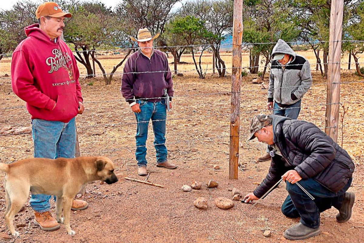
In Tomás Urbina, in the Interior of Durango, The Search for Water Leaves the Machine Field and Enters the Ant Hills: Dom Rafael Calderón Reads Stones with Metal, Measures Currents with Rods, and Confirms Depths with a Pendulum While Owners Discuss a 100-Meter Well That Failed and Requests More Drilling
In the ejido of Tomás Urbina, in Durango, a group arrives to review a well that has already received 100 meters of drilling and still did not sustain water. The scene mixes tension and curiosity: the landowner, Jesús Monroy, accompanies the visit, while Armando Shoa reports the frustration of seeing water appear for a short time and disappear.
The person responsible for reading the land is Dom Rafael Calderón, who claims to identify water from ant hills and measurements with rods and a pendulum. The central argument is simple and uncomfortable: without machines and without maps, the signals would be on the ground, and the well may have failed by “missing” the underground current, even being close to it.
The 100-Meter Well and the Unresolved Doubt
The starting point is a well that would have been drilled up to 100 meters and, according to local reports, managed to release water for about a minute before it “died.”
-
Couple Transforms Abandoned Farm in São Paulo into Major Poultry Operation with 295,000 Birds and Plans for Expansion

-
U.S. Giants Oppose New 25% Tariff on Brazilian Imports, Warn of Impact on Electric Cars, Coffee, and Orange Products

-
Off-Duty Firefighter Rescues Three Children Trapped Under Overturned Boat in Brazilian Lake

-
Workers near the Vatican uncover lead pipe revealing Emperor Caligula’s name and site of his opulent garden from nearly 2,000 years ago

The team tries to turn this diffuse feeling into a diagnosis: if the water is scarce, if the current “ruptured,” or if the depth did not reach the right range.
In this context, the word well appears as a problem and a bet.
The idea is not to promise miracles, but to decide whether the well should be deepened, abandoned, or replicated at another point, always with the same declared goal: to find water in a useful volume without relying on blind trial and error.
Why Ant Hills Become Water Markers
The observation begins with the land “full of ant hills,” with the thesis that they indicate areas where moisture and vapor rise from the underground.
Dom Rafael describes the ant hill as a “volcancito” that releases vapor and, therefore, would be a repetitive point for locating water and even for detecting the “first current” at depth.
To support the hypothesis, he highlights the stones placed on the ant hills.
According to the demonstration, the stones would have metal and respond to a magnet, and the “rocky area” of the ant hill would allow the sun to act on these stones, raising the vapor.
The technical detail here is not the poetry of the story, but the operational logic: the ant hill becomes a fixed reference, and water becomes the measurement target.
How Rods and the Pendulum Enter the Measurements
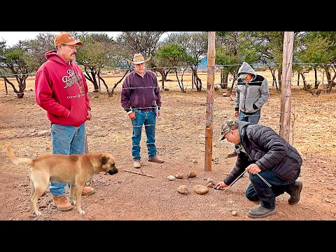
The described procedure relies on rods and a heavier pendulum, chosen not to be “moved by the air.”
The team walks, presses the rods, and observes the moment when they “turn” or change direction, interpreting this as passing over a water current.
The measurements appear as numbers that try to give concreteness to the method.
There are mentions of markings at 125 meters for the “first current,” readings at 131 to 137 meters at another point, and a mark around 161 meters considered stronger.
In parallel, the conversation brings “inches” as a way to estimate flow, highlighting a point at 171 meters associated with “nine inches,” treated as indicative of more water.
What the Group Concludes About Depth and Failures of the Well
The final assessment does not describe an immediate solution but a recommendation for a decision.
Dom Rafael suggests that the current well would have a “future” if it receives more depth, even mentioning the hypothesis of working another 100 meters to reach more consistent currents and allow the water to form a “vessel,” an idea used to explain why the pump cannot be too high.
The same reasoning tries to explain why a well may be deep but still not yield water: the currents would be “tubed” by waterproof conduits over a long time, and a hole off-center “cracks” the passage without opening the current.
He also attributes losses to tremors that create fissures, diverting water out of reach of the well. Even within the narrative, the critical point is recognizing that confirmation only comes with drilling and testing.
The Discomfort That Remains When Water Becomes a Method Bet
The case draws attention because it transforms a popular perception into a procedure: ant hills as a map, rods as an instrument, and pendulum as control.
This creates a direct contrast with the expectation of those who invested in a well: after 100 meters, the pressure for answers increases, and any method that promises to reduce risk gains space in the conversation.
At the same time, the conversation itself suggests limits. The reading of “currents” varies between nearby points, and conclusions depend on interpretation, not measuring by standard equipment.
That is why the issue cannot be resolved with faith or irony: either the well finds water stably, or the hypothesis falls for lack of results, and the cost of making a mistake continues to be borne by the owner.
The story in Tomás Urbina exposes how the search for water can migrate from machines to local signals, with ant hills serving as a reference and rods and pendulum trying to translate what might be hidden underground.
In the center, the well remains a symbol of a bet: 100 meters have already been made, and the debate now is whether deepening is rational insistence or costly insistence.
If you have ever lived through a similar decision, what was the criterion that weighed most to invest in a well and search for water: field reports, signals from the land, or just drilling until it “works”? In case of doubt, would you trust ant hills, rods, pendulum, or none of them?


Já cavei 26 poços de 80mts a 172mts, não tive êxito em nenhum deles, fiz marcações com varinhas ferrinhos pêndulos, Geólogos etc, sem sucesso.
Sério mesmo