
 Portuguese
  Spanish
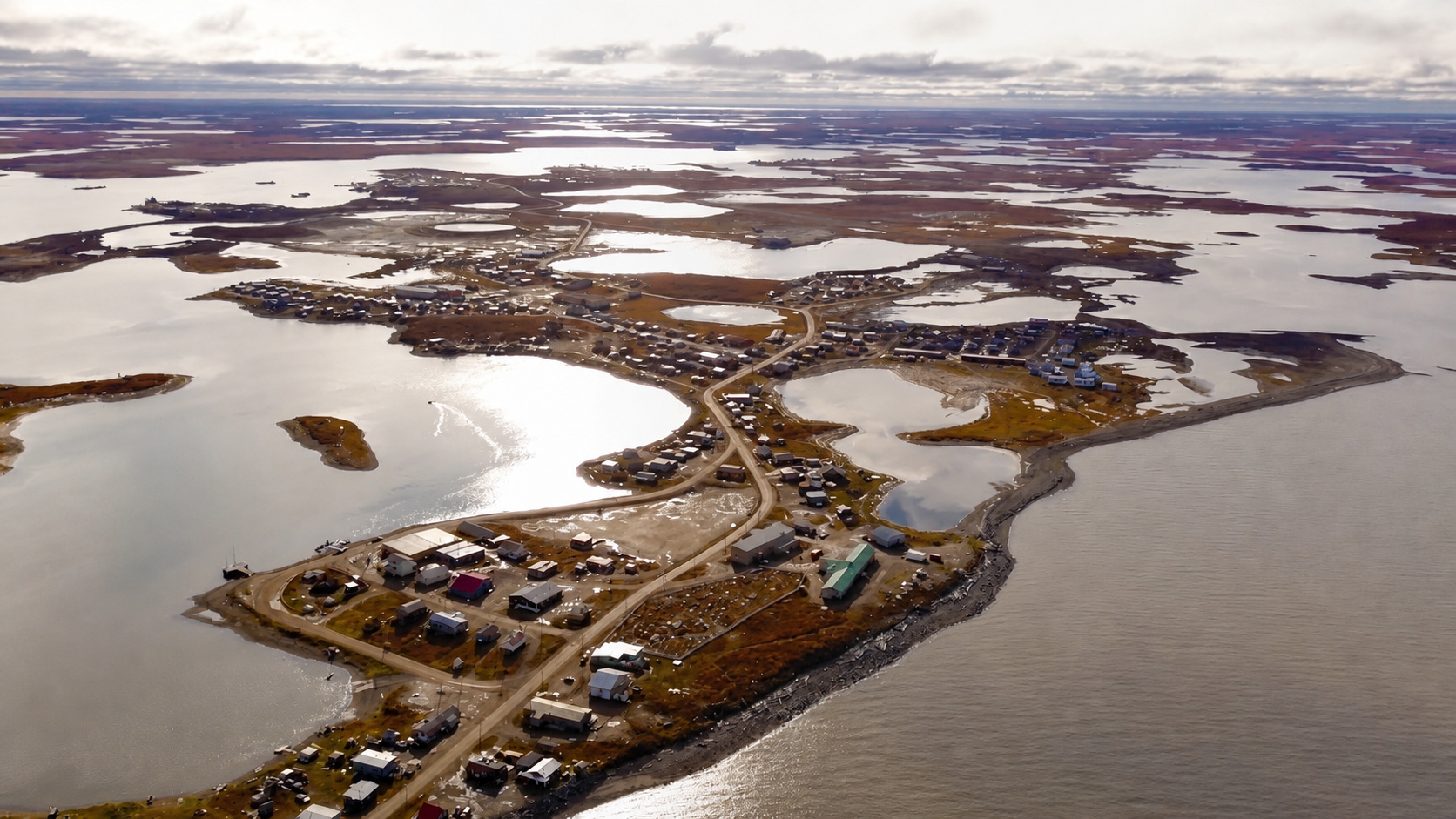
Government of Canada invests C$53.7 million to protect Tuktoyaktuk, an Inuvialuit village in the Arctic, where permafrost melts, the coast recedes up to 3 meters per year, and storms can already rip away 5 meters of land in a single event.
According to the Government of Canada, on July 27, 2023, the Canadian federal government announced an investment of C$53.7 million to mitigate the impacts of climate change on the coastline of Tuktoyaktuk, an Inuvialuit village of just over a thousand people located on the shores of the Beaufort Sea, in the Northwest Territories, about 200 kilometers above the Arctic Circle.
The money will finance armor stones, geotextiles, and industrial styrofoam buried under the coastline to insulate the permafrost from the heat of waves and warmer air. The work is complex, expensive, and according to the project itself, offers protection only until 2052.
This is what climate engineering can offer today to a community that loses between 0.3 and 3 meters of coastline per year, and up to 5 meters in a single intense storm, while the frozen soil that supported their homes for generations melts from the bottom up.
-
Federal Police involved in the case to identify the person responsible for hacking the Civil Defense system, which sent ten false alerts, frightened residents of different capitals, and turned messages about real risks into notifications with “misanthropy” and even alien attacks.

-
Extreme drought causes ghost village to reappear at the bottom of the reservoir that supplies Athens, revealing houses, a school, and ruins swallowed since the 1980s as the lake shrinks and exposes the water crisis threatening the capital of Greece.

-
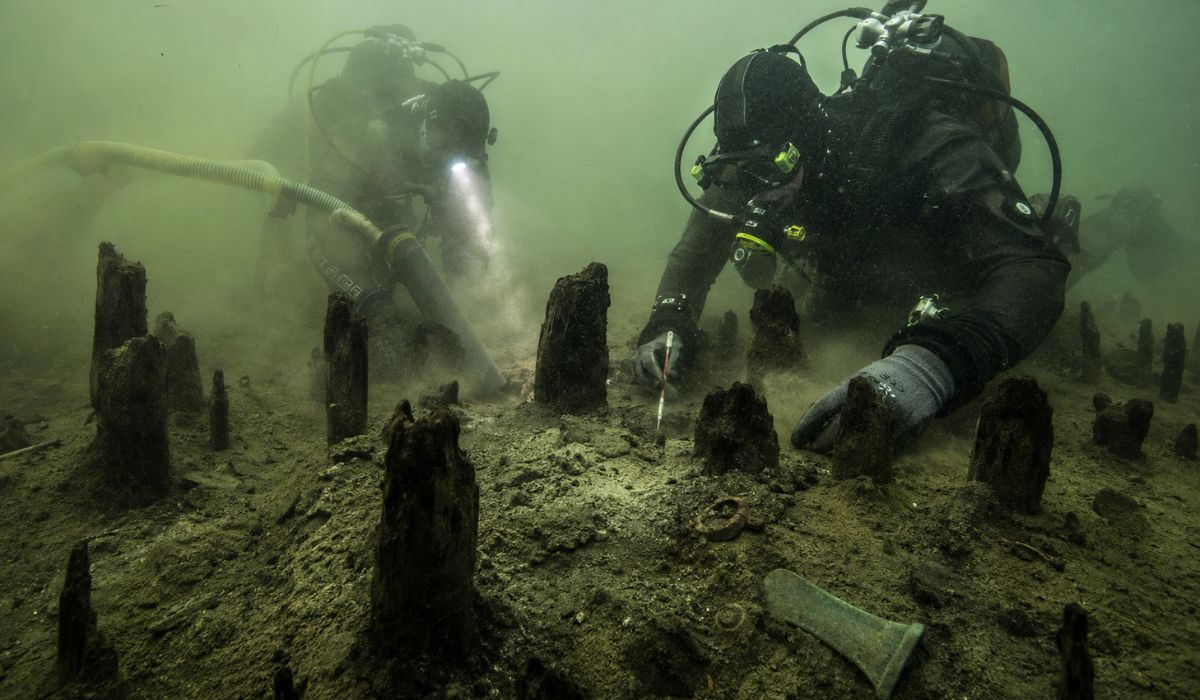
An entire village lay asleep at the bottom of a lake for 3,000 years: divers suction sediments in Italy and reveal more than 600 wooden stakes, bronze tools, and traces of a Bronze Age settlement hidden underwater.
-
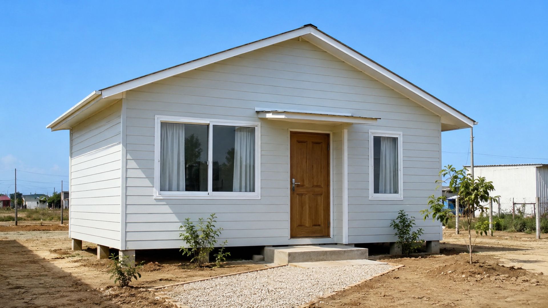
They call it the “Shopee house” and even cardboard, but the R$ 20,000 house is a certified Wood Frame from Alea, financed by Minha Casa Minha Vida: understand if it’s worth more than masonry.


Tuktoyaktuk is an Inuvialuit community built on permafrost on the shore of the Beaufort Sea
Tuktoyaktuk is not a city built by chance. It is an Inuvialuit community with millennia-old roots on that stretch of the Canadian Arctic coast, on a peninsula of sand and permafrost projecting into the Beaufort Sea.
The location was chosen for fishing, whale and caribou hunting, access to ice sea resources, and the natural protection of Tuk Island, an island that acts as a barrier against storms coming from the north and northwest.
Houses, schools, a health center, the Arctic College campus, the Canadian Coast Guard base, and the port that supplies isolated communities in the region were built on permafrost. Everything depends on soil that only remains firm as long as it stays frozen.
The Arctic warms faster than the rest of the planet and exposes the coast to waves for more months
The problem is that this soil no longer remains frozen as before. The Arctic warms about four times faster than the global average, and summer temperatures in Tuktoyaktuk have risen between 2°C and 4°C in recent decades.
The sea ice that once protected the coast in summer used to arrive earlier and retreat later. Now, it forms later and disappears earlier, leaving the coastline exposed to the direct action of waves for more months than in previously recorded periods.
With more heat in the air, more heat in the sea, and less ice acting as a shield, the permafrost begins to thaw from the edges, the surface, and underground. The coast is no longer just eroded. It begins to lose the very structure that kept it cohesive.
Erosion in Tuktoyaktuk combines waves, subterranean thawing, and loss of cohesion of frozen soil
Coastal erosion in Tuktoyaktuk does not work like on tropical beaches, where sand is removed by waves and can be deposited elsewhere. In the Arctic, the process is more destructive because it combines mechanical erosion and thermal erosion.

Mechanical erosion occurs when waves from the Beaufort Sea, now without the protection of sea ice for a larger part of the summer, directly hit the coastline and remove sediments from the base of the bluffs.
Thermal erosion is even more severe. Ice-rich permafrost is not just frozen soil: it contains pockets, lenses, and layers of pure ice, which can represent 50% to 80% of the volume of the upper layers in some areas. When this ice melts, the soil loses cohesion, slides into the sea, and is carried away by the waves.
Tuk Island protects the port, but could be breached by the sea before 2050
Tuk Island, which protects the community’s inner harbor from the most dangerous storms, is also receding. The average rate is about 1.8 meters per year, according to the base text, which puts Tuktoyaktuk’s main natural barrier at risk.
Without intervention, models project that the island could be breached by the sea before 2050. When this happens, the port will be directly exposed to the open waves of the Beaufort Sea.
The consequence extends beyond the village itself. Vessels may have difficulty docking safely, and the supply of dozens of isolated communities that depend on the port of Tuktoyaktuk could be compromised.
Old structures failed because they were built for common coasts, not for collapsing permafrost
Tuktoyaktuk has been trying to protect its coastline for over fifty years. The first records of coastal defense structures date back to the 1970s, when concrete blocks were installed to fill gaps left by permafrost subsidence.
In the following decades, geotextiles were used to protect sediments from wave action, sandbags were placed in front of the cemetery, and armor stones were laid at different points along the coast.
These solutions failed within a few years or only marginally slowed the retreat. The combination of stronger waves and permafrost thaw produces an aggressiveness that conventional temperate coastal structures cannot withstand.
The C$53.7 million project uses stones, geotextiles, and polystyrene foam to try to preserve the frozen ground
The project approved in 2023, with C$53.7 million from the Canadian federal government, differs from previous attempts in scale and conception. It combines multiple layers of intervention to reduce wave energy and slow permafrost thaw.
Large armor stones form the outer face exposed to the sea, dissipating wave energy before it reaches the ground. Beneath them, smaller layers of filter stones allow water to pass through the structure without dragging sediments.

Buried beneath the system, a layer of industrial polystyrene foam acts as thermal insulation. The goal is to reduce heat transfer from water and air to the permafrost, slowing the melting that destroys coastal cohesion.
The project requires tens of thousands of cubic meters of stone, geotextile, polystyrene foam, and sand
The excavation required to bury the insulation reaches 1 meter below the surface, down to the permafrost and rock. The projected volume of material shows the scale of the intervention in a community of just over a thousand people.
The project involves more than 30,000 cubic meters of large armor stones, more than 30,000 cubic meters of smaller filter stones, nearly 40,000 cubic meters of polystyrene foam, more than 40,000 cubic meters of geotextile, and more than 10,000 cubic meters of infill material.
Over its 30-year lifespan, more than 60,000 cubic meters of sand will still need to be brought in to periodically replenish the beach. It is not a one-time project. It is a protection that requires continuous maintenance.
The first phase advanced in 2024, but storms and lack of stone delayed part of the work
The first phase was completed in 2024, with stones and geotextiles along the most critical shoreline. Even so, execution faced difficulties typical of Arctic construction, where logistics, climate, and material availability make any intervention slower and more expensive.
In May of that year, winter storms and a shortage of certain types of stone meant that only 50% of the planned work was completed. Work continued in the summer and winter of 2024 to 2025.
Part of the transport was done with trucks carrying gravel over ice roads to the island. The protection work itself depends on seasonal infrastructure that is also being pressured by the warming Arctic.
Engineering buys time until 2052, but does not solve the permanent threat to Tuktoyaktuk
Tuktoyaktuk has about a thousand inhabitants, and its municipal revenue is small. The C$53.7 million invested by the federal government represents more than a community of this size could raise in decades of local taxes.
Even so, the protection is temporary. The project has a 30-year lifespan and was designed for a sea level rise of 3.4 meters, a margin that more recent climate models already consider conservative for the Arctic until 2100.
The central question is what will happen in 2052, when the guarantee expires. The technical answer is direct: the work buys time, but does not eliminate the climate problem that is destroying the physical foundation of the community.
After 2052, the community will have to choose between maintaining defenses, retreating, or combining the two strategies
The options appear in the long-term adaptation plan: maintain protections and invest in increasing maintenance as conditions worsen, progressively relocate structures and residents to higher areas further from the coast, or combine the two strategies.
Resident Noella Cockney, whose family had to move their house away from the coast in 2020, described the concrete timeline of this threat. The family built where they did because the ground was firm and the location seemed safe.
The ground may still feel firm when someone walks on it. But it’s no longer the same. The proof is the piece of land where the house once stood, now underwater.
Tuktoyaktuk shows how Arctic communities face a crisis they didn’t cause
Tuktoyaktuk’s situation is not unique. It is one of the most documented, publicized, and funded cases of a pattern that repeats in dozens of communities along the Arctic coast of Canada, Alaska, and Siberia.
Copernicus University published a mapping of submarine permafrost around Tuk Island in 2025 using electrical resistivity tomography. The technique measures how electrical current propagates through submerged soil to identify where permafrost begins and where it has already thawed.
The results indicate that the submarine permafrost around the island is shallower and more fragmented than previous models predicted. This means that erosion of the submerged base may be advancing faster than surface measurements indicated.
Coastal protection allows for continued living for more years, but doesn’t promise to save Tuktoyaktuk forever
Tuktoyaktuk’s coastal engineering project should buy years, perhaps decades, for a community that has not caused significant industrial emissions, has not burned coal at scale, has no heavy industry, and does not have intense automobile traffic.
The village has spent millennia in balance with an environment that the rest of the industrial world is altering from the outside in. Now, it needs rocks, geotextiles, styrofoam, and federal funding to remain in the place where it has always been.
Mayor Erwin Elias was precise when announcing the C$53.7 million in July 2023: “This means that the Inuvialuit and local residents of Tuktoyaktuk will be able to continue living, working, and enjoying their land and culture, safely, for many more years.”
For many more years. Not forever. For many more years.


Be the first to react!