Portuguese
  Spanish
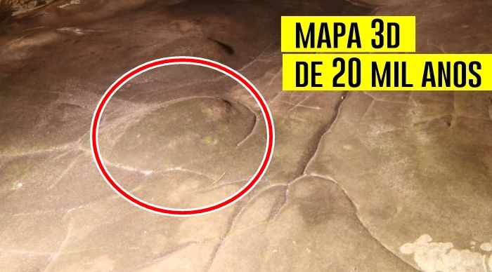
Archeologists Discovered The Oldest Three-Dimensional Map Ever Registered In A Prehistoric Cave In France, With Surprising Details That Indicate How Our Ancestors Represented Their World Thousands Of Years Ago.
Scientists from France and Australia announced an impressive discovery in the depths of a cave in southern Paris: what could be the oldest three-dimensional map ever found, approximately 20,000 years old.
The discovery was described as an accurate representation of the geographic features of a prehistoric valley, which may transform our understanding of the ability of ancient peoples to interpret and represent the world around them.
According to experts Médard Thiry and Anthony Milnes, the cave Ségognole 3 hides a detailed map of the territory where the hunter-gatherers of the time likely lived.
-
How Much Does Starlink Satellite Internet Cost for Cars, Trucks, and RVs? Prices for Antenna, Accessories, and Plans

-
Scientists Convert Food Waste into Aviation Fuel, Successfully Test 50% Blend with Conventional Kerosene to Cut Emissions and Promote Sustainable Flights
-
OnePlus N6 Smartphone to Launch in India with 8,000mAh Battery and 45W SuperVOOC Charging, Lasting Up to Three Days
-
Scientists Plan to Release Air Bubbles Underwater to Protect Antarctica’s “Doomsday Glacier” from Melting


The Cave Ségognole 3
The cave Ségognole 3 is part of a sandstone complex in southern France, famous for its more than 2,000 rock engravings from the Stone Age.
However, what geoscientists discovered on the cave floor goes beyond the limits of traditional rock art: a kind of miniature of the surrounding valley, sculpted with impressive detail.
The discovery was made by geoscientists Médard Thiry from the French Geosciences Center and Anthony Milnes from the University of Adelaide in Australia.
They identified a series of grooves and depressions on the cave floor that form a complex system of channels and basins that accurately mimics the pattern of water flow in the local territory.
The cave Ségognole 3 dates back to the end of the Upper Paleolithic Period, when the first human settlements began to establish themselves.
During this period, hunter-gatherers already possessed impressive skills in adaptation and knowledge of their environment.
Although few examples of rock art from the time have been found, the discovery in the cave Ségognole 3 suggests that, in addition to engravings of animals like the two horses found, the people of that time were also creating much more complex representations of the landscape around them.

Pascal Crapet, Fontainebleau/Courtesy of Médard Thiry for labrujulaverde.com )
The Art of Mapping The World
The map found in the cave is not a conventional geographic representation. Instead of a simple outline of the external landscape, the carved floor of the cave appears to be an inverted and modified version of the surrounding area, likely due to the natural slope of the terrain.
However, geoscientists claim that the features of this “map” are easily recognizable, such as rivers, deltas, lagoons, and hills.
Thiry and Milnes detail how rainwater infiltrated the cave, creating a pattern that followed a river network.
The basins present on the cave floor not only represent bodies of water but were also manipulated by humans, who intelligently enlarged and deepened them.
One of the most impressive elements of the discovery is a large elevated basin that appears to have been created to function as a “water tower,” feeding the rainwater that flowed through the channels of the map.
The Precision Of The Design
The precision with which the grooves and basins are sculpted in the cave suggests that those responsible for this work had an impressive capacity for abstraction and spatial reasoning.
Each detail seems to be part of an elaborate design, with rivers splitting, connecting, and forming complex networks of deltas.
The “hills” and “mounds” found on the map are perfectly rounded, and some are surrounded by deep grooves, reinforcing the idea that we are facing a faithful representation of the local valley characteristics.
Moreover, the absence of repetitive patterns suggests that the map is not just a representation of the landscape but a model that expresses the spatial relationships between the different natural features of the area.
This indicates that the map may have been used in various ways: as a guide for hunters, as a teaching tool about local geography, or even as part of rituals related to water.

Oxford Journal of Archaeology , 2024)
A New Perspective On Ancient Peoples
This discovery brings to light a new perspective on prehistoric peoples and their cognitive abilities. Scientists believe that this map may be more than a mere artistic representation.
It may be an example of how the ancient inhabitants of the region utilized geographic knowledge functionally.
The cave Ségognole 3 may have been a place of learning, rituals, or even a meeting point for those who needed to understand the complex relationships between water, territory, and natural resources.
Although interpretations of prehistoric art should always be approached with caution, the study by Thiry and Milnes suggests that the terrain sculpture in the cave Ségognole 3 is one of the most impressive pieces of evidence that early humans were capable of mapping and understanding their world in complex and profound ways.
Final Considerations
The discovery of the 3D map in the cave Ségognole 3 not only broadens the understanding of prehistoric peoples about the geography of their territory but also challenges traditional notions about the intellectual capacity of these civilizations.
The complexity of the map, with its basins, channels, and perfectly drawn grooves, reveals an abstract thought and a level of sophistication unimaginable for such a remote time.
The study of this and other similar discoveries may, in the future, provide valuable insights into the mapping practices and territorial organization of the early human groups.
The complete article of the research was published in the Oxford Journal of Archaeology and promises to continue to fascinate experts and laypeople about the incredible abilities of prehistoric peoples and their ways of interacting with the surrounding environment.