
 Portuguese
  Spanish
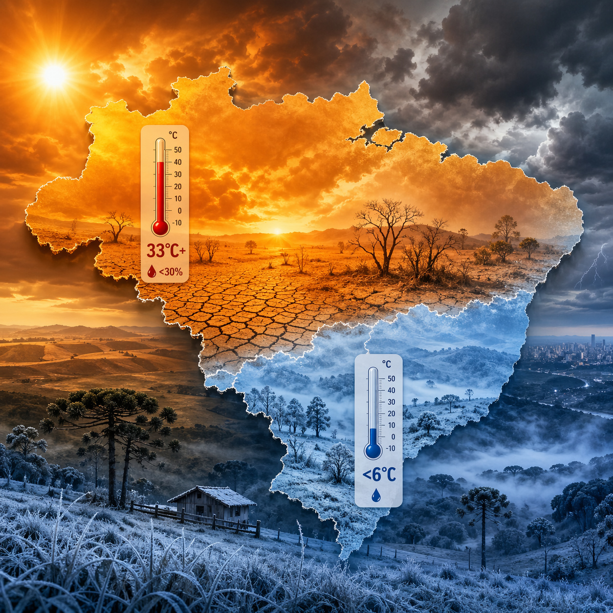
Brazil faces simultaneous climate extremes, with frost in the South and heat with low humidity in the Central-West due to an atmospheric block.
Simultaneous climate extremes: According to an alert published by Climatempo on April 20, 2026, Brazil entered its second autumn and 2026 heatwave between April 20 and 26, with temperatures at least 5°C above the April average in areas of Mato Grosso do Sul, Goiás, Mato Grosso, Triângulo Mineiro, western and northwestern São Paulo, and the extreme northwest of Paraná, while other parts of the Central-West and Southeast remain under intense heat, even if outside the technical criteria for a heatwave.
In the same scenario, a more intense polar air mass advances over Southern Brazil starting Sunday night, April 26, with a more significant drop between Monday (27) and Tuesday (28), when Climatempo itself predicts the coldest day of the year so far in areas of Rio Grande do Sul and minimums close to 0°C to 2°C in Campos de Cima da Serra and the Southern Catarinense Plateau; in a report released on April 20, INMET also pointed to stronger heat in central-southern Mato Grosso and central-northern Mato Grosso do Sul, while also projecting instability and a change in weather patterns in the South.
In practice, the areas of action described by the forecasts show that the two events can occur simultaneously in different parts of the country, without one immediately eliminating the other.
-
James Webb Telescope Uncovers Unexpected Clues on Mysterious Moon, Potentially Redefining Planetary Origins

-
$1.5 Billion Sleipnir Vessel Transforms Ocean into Floating Construction Site with 12 Hybrid Engines and Capacity to Lift 20,000 Tons

-
23 Years After Tragedy, Brazil’s Alcântara Space Center to Launch New Suborbital Rocket in 2026 with South Korean SEBIT Project Targeting Near-Space Tests
-
Entrepreneur Turns Neighbor’s Coffee Grounds Waste into Eco-Friendly Pellets, Earning Up to $40,000 Monthly in Brazil


Atmospheric block explains why extreme heat and intense cold coexist in Brazil
The central mechanism behind this contrast is the atmospheric block, a high-pressure system that forms between 5,000 and 10,000 meters in altitude and remains stationary for days or weeks.
Under normal conditions, cold fronts and rain systems move from west to east, continuously crossing the national territory. When a block is established, this flow is interrupted.
The upper-level jet stream divides, and the meteorological systems become dammed. Cold polar air is diverted to the ocean, while heat accumulates in the central regions of the country.
Temperatures above 33°C and low humidity characterize heatwave in the Central-West and Southeast and climate extremes
The atmospheric block positions itself over the Southeast and prevents cold fronts from entering these regions. The result is a persistent increase in temperatures.
In the city of São Paulo, projected maximums reach 33°C, while in cities like Cuiabá, Goiânia, and Brasília the heat is even more intense.
The situation worsens with the drop in relative air humidity, which falls below 30% in several areas of the Central-West. In some regions, indices approach 20%, a level considered critical for human health.
Technical criterion defines heatwave as temperatures 5°C above average for five consecutive days
The World Meteorological Organization defines a heatwave as a period of at least five consecutive days with minimum and maximum temperatures significantly above the historical average, usually more than 5°C above normal for the season.

INMET classified the center, north, and east of Mato Grosso do Sul, southern Goiás, parts of Mato Grosso, western Minas Gerais, as well as regions in the interior of São Paulo and Paraná, as areas of maximum alert for a heatwave.
Low humidity increases health risks and raises the probability of forest fires
The combination of high temperatures and low humidity intensifies health impacts. Dry air causes irritation in the respiratory tract, increases the risk of nosebleeds, and worsens respiratory problems. It also favors the occurrence of wildfires and forest fires, especially in areas with dry vegetation.
While the Midwest faces intense heat, Southern Brazil receives a significant incursion of polar air. The cold air mass began to advance through Rio Grande do Sul on Sunday, April 26, driven by an extratropical cyclone formed in the South Atlantic.
Minimum temperatures are expected to drop below 10°C in a large part of Rio Grande do Sul and Santa Catarina, with values between 6°C and 9°C in the mountainous regions.
Frost hits agricultural areas in the South and worries rural producers at the start of the harvest
The forecast indicates frost formation in several regions of Rio Grande do Sul and Santa Catarina, including Campanha, Serra do Sudeste, Planalto Médio, and Campos de Cima da Serra.
This phenomenon can impact newly planted winter agricultural crops, increasing the risk of losses at the beginning of the productive cycle.
Paraná presents one of the clearest examples of climatic contrast in the country. While the south and east of the state record lower temperatures, with lows between 12°C and 17°C, the north and northwest maintain highs above 33°C before the arrival of the cold front.
Recurrent atmospheric blockages indicate a climatic pattern that may repeat in the coming months
The pattern observed in April 2026 is not isolated. Similar events occurred in 2024, when atmospheric blockages prevented the advance of cold fronts and contributed to the concentration of rainfall in the South, culminating in extreme events.
Climatempo projects that the average temperature for the month should remain above normal in most of the country.
The global climatic context also influences this scenario. INMET confirmed in March the formation of the El Niño phenomenon, with about 90% probability of consolidation in the second half of the year.
In El Niño years, atmospheric blockages tend to occur more frequently, especially over the Southeast, reinforcing patterns of persistent heat and irregular rainfall distribution.
Simultaneous climate extremes show a new meteorological pattern with direct impacts in Brazil
What is happening in the last week of April 2026 is not just a punctual anomaly. It is an example of a climatic pattern where extremes do not succeed each other, but coexist at the same time, requiring simultaneous responses from different sectors.

While some regions deal with extreme heat and drought, others face intense cold and the risk of frost during the same period.
The coexistence of intense heat and extreme cold in the same territory poses challenges for agriculture, infrastructure, and climate planning.
In your view, is the country prepared to face this new pattern of simultaneous extremes, or does it still operate with strategies based on more predictable scenarios?


