Portuguese
  Spanish
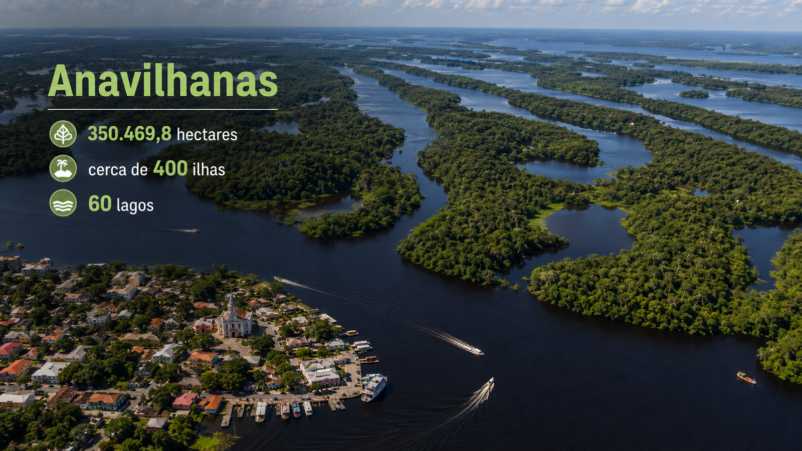
On the banks of the Rio Negro, Novo Airão serves as an urban base for the Anavilhanas National Park, where hundreds of islands, lakes, channels, and flooded forests shape tourism, conservation, and riverside life
With about 400 islands and 60 lakes in the lower Rio Negro, Anavilhanas positions Novo Airão, in Amazonas, as a base for tourism, research, and conservation in a large river archipelago.

Novo Airão connects city, river, and Anavilhanas
Novo Airão occupies a strategic position on the banks of the Rio Negro, where the urban area connects to islands, channels, lakes, flooded forests, and channels protected by the Anavilhanas National Park.
The municipality hosts the administrative headquarters of the federal unit, according to the official registry. The park is located in the Amazon biome, covers 350,469.8 hectares, and has its institutional address in the municipality itself.
-
Coastal City in Rio de Janeiro Faces Slow Destruction as Sea Claims 500 Homes and Businesses

-
48-Year-Old Woman Wins Million-Dollar Prize, Gifts Neighbor First International Trip as Thanks for Years of Support

-
Women Once Mocked for Collecting Trash Form Group to Turn Organic Waste into Compost, Generate Daily Income, and Improve Market Cleanliness in One of the World’s Lowest GDP per Capita Countries
-
Archaeologists Uncover 40,000 Roman Bronze and Copper Coins from the 3rd Century in Fire-Destroyed French Neighborhood


This proximity makes the city a natural gateway to the aquatic environment. From there, visitors can embark on boat tours, visit seasonal beaches, riverside communities, and channels connected to the park.
Archipelago gathers islands, lakes, and flooded forest
The Anavilhanas archipelago is located in the lower Rio Negro and consists of islands, lakes, channels, beaches, and flooded forest areas. Official tourist information describes the park as the second-largest river archipelago in the world.
The landscape changes according to the water regime. During the flood, paths disappear, and the flooded forest dominates the experience. During the dry season, beaches, sandbanks, and exposed banks appear.
These changes alter routes, attractions, and circulation. Therefore, visits depend on the river level, local knowledge, and navigation in a natural system.

Streets seem to end at the channels of the Rio Negro
In Novo Airão, the relationship between city and river is direct. The journey to Anavilhanas happens by boats, with local departures to protected areas, channels, and islands.
The city functions as a transition point between urban infrastructure and Amazonian navigation. The visitor leaves inns, restaurants, and shops and enters a complex river system.
During the journeys, orientation depends on guides, river level, and accumulated knowledge of those who navigate the region. The impression is that the streets end in water.
Aquatic complex depends on the pulse of the waters
The Anavilhanas complex combines river, forest, islands, and floodable areas. The attraction lies not only in the landscape but also in the ecological functioning of this system.
The water reorganizes access, habitats, beaches, and routes throughout the year. Among the central elements are the Rio Negro, river islands, interior lakes, narrow channels, passages used in local navigation, and flooded forests.
Also part of this environment are the seasonal beaches, the fauna associated with aquatic spaces, and the riverside communities. These components show that the park is not just a set of islands.
It is a dynamic territory where conservation, tourism, navigation, and ways of life depend on the annual pulse of the Amazonian waters and the knowledge of the riverside communities.

Environmental management guides visitation and preservation
ICMBio is responsible for managing federal conservation units, including the Anavilhanas National Park.
The official record notes its creation by Decree No. 86.061, of 1981, and recategorization by Law No. 11.799, of 2008.
This management defines rules for visitation, research, biodiversity conservation, and public use. In sensitive areas, control prevents disorderly tourism, protects aquatic habitats, and guides compatible activities.
Natural heritage reinforces the identity of the city of Novo Airão
The recognition of Anavilhanas enhances the tourist relevance of Novo Airão. Iphan records that the river part of the park, with more than 400 islands, represents 60% of the unit.
The mainland corresponds to the remaining 40% of the 350 thousand hectares. This composition connects city, river, and conservation, strengthening the local identity in the face of a rare territory.
Novo Airão acts as an urban base of a natural labyrinth of the Amazon, where daily life coexists with islands, channels, and flooded forest.
With information from Market Monitor.