Portuguese
  Spanish
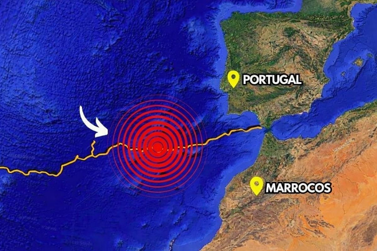
A New Study Suggests That a Deep Fracture Beneath the Atlantic off the Iberian Peninsula May Be Behind Some of the Largest Earthquakes in European History, Including the Devastating Shock of 1755 That Destroyed Lisbon and Generated a Deadly Tsunami.
By analyzing in detail the region of the Horseshoe Abyssal Plain, at the boundary between the African and Eurasian plates, scientists identified signs that the base of an oceanic plate is detaching and slowly sinking toward the mantle. This deep delamination process creates a kind of hidden fissure and helps explain how an apparently flat area with no major known faults managed to produce earthquakes of magnitude 8 or higher and tsunamis that affected the entire North Atlantic.
The Enigma of Large Earthquakes Far From Subduction Zones
When discussing megathrust earthquakes, the classic image is one of a large subduction zone, where one tectonic plate sinks beneath another, as happens in Japan, Chile, or Indonesia.
In these scenarios, the physics is relatively well understood: plates collide, accumulate tension, and periodically release energy in massive shocks.
-
A nearly 70-year-old Chinese inventor has registered 90 patents and created a device that stores water in the roots, helping seedlings survive drought while trying to transform the arid slopes of the Loess Plateau into green areas without relying on heavy irrigation.

-
Researchers want to change the way of producing rare earth magnets, reducing purification steps and making better use of the elements found in Swedish deposits.
-
5.5 tons pulled from the seabed: a ‘living carpet’ of invasive coral was suffocating the Baía de Todos-os-Santos until the Brazilian Navy descended with divers, steel brushes, and acid salt to carry out the largest eradication operation of the species ever conducted in the country.

-
A Brazilian project dumped 5,500 concrete blocks and 2 barges into the ocean to block trawling in Paraná, and 25 years later what seemed like a risky intervention turned into an underwater nursery, a diving spot, and a refuge for endangered species.


The problem is that the large earthquakes that struck Portugal in 1755 and 1969 do not fit this pattern.
They occurred in a region of the Atlantic considered a “diffuse” margin, seemingly flat, with no obvious main fault like the known large subduction zones.
The 1755 earthquake, estimated to be nearly 8.7 or 9 in magnitude, devastated Lisbon, generated a tsunami that killed tens of thousands of people, and marked the history of European seismology.
Almost two centuries later, in 1969, a new event of magnitude 7.9 shook the Atlantic west of Cape Saint Vincent.
Thanks to the instrumentation available in 1969, it was possible to better locate this second quake in the Horseshoe Abyssal Plain, near structures like the Gorringe Bank and the Coral Patch seamount, between the African and Eurasian plates.
Even so, the mystery remained: why could an abyssal plain seemingly “without faults” generate such large earthquakes?
What Scientists Found in the Deep Fracture Beneath the Atlantic
The new study indicates that, about 200 kilometers off Cape Saint Vincent, a portion of the tectonic plate is literally separating from within.
Instead of a vertical fault that splits the seabed into two visible blocks, what is happening is a horizontal fracture.
In this process, known as delamination, the plate behaves as if it were a rock cut by a blade: the lower, denser part begins to detach and sink toward the mantle, having already reached depths of around 200 kilometers, when the “normal” would be something on the order of 100 kilometers.
The upper part remains almost in the same position, horizontal, with no significant visible deformations on the surface.
This means that the deep fissure beneath the Atlantic does not appear as an obvious “tear” in the seabed, which explains why decades of morphological observations did not identify a clear fault large enough to generate the significant historical quakes.
The main “rupture” is occurring within the plate, many kilometers below the ocean floor.
An Oceanic Delamination That Could Mark the Beginning of a New Subduction
Until now, delamination was more associated with continental lithosphere, not oceanic lithosphere. The novelty here is that seismic data and numerical models suggest what may be one of the first documented cases of oceanic plate delamination, precisely in this region of the Horseshoe Abyssal Plain.
In seismic tomographies, which function like a kind of “ultrasound of the Earth,” researchers saw an anomaly that seemed to indicate that the base of the plate was separating, “like the sole of a shoe peeling off,” in the words of one of the researchers. This was the first clue that something very unusual was happening “down there.”
The second decisive moment came when computer simulations were able to reproduce the same process of oceanic delamination.
By combining observations from land seismographs, sensors on the seabed, and numerical models, the delamination hypothesis gained strength as an explanation for the origin of the region’s large earthquakes.
At the same time, this structure may represent the embryo of a new subduction system developing beneath the Atlantic.
In the long term, processes of this type are linked to the very cycle of ocean opening and closing, raising the possibility that this area is one of the points where the Atlantic might very slowly begin to close.
How the Deep Fissure Beneath the Atlantic Generates Earthquakes and Tsunamis
If the plate is separating horizontally, why does this generate strong earthquakes? The answer lies in the contact between plates. The African plate is slowly converging towards the Eurasian plate. It is as if two books are being pushed into each other.
In the region where delamination occurs, the separating plate begins to “enter” into the other one, behaving like a sheet that is inserted into the middle of a book.
A void does not open; the space is occupied by another rock, always maintaining contact between surfaces. This contact, however, is more horizontal and deeper, which creates friction zones where energy accumulates and can be released in the form of earthquakes.
This exact combination of observations caught scientists’ attention:
- a “cluster” of small earthquakes at great depths, between 30 and 40 kilometers, recorded over eight months by seismographs installed on the seabed
- the seismic tomography anomaly suggesting the plate peeling off underneath
- the absence of an obvious surface fault that could explain large magnitudes
All of this points to a hidden but active process capable of generating powerful earthquakes and, in certain cases, tsunamis that hit the margins of the Atlantic.
Understanding this deep fissure beneath the Atlantic is essential to better assess seismic and tsunami risk in countries like Portugal, Spain, and even other regions bordering the ocean.
Impacts on the Seismic Risk Map in the Atlantic
The new hypothesis does not turn earthquakes into predictable events, but it changes the way risk is interpreted.
Until now, the absence of a mapped giant fault in the Horseshoe Abyssal Plain was an enigma that hindered the complete characterization of hazard.
With the identification of the deep fissure beneath the Atlantic, associated with the delamination of the plate, this region is now viewed as an active system that needs to be included in risk models.
This includes both the likelihood of new strong earthquakes and the potential for tsunamis generated by events at great depths but capable of displacing the seabed or affecting large volumes of water.
The study reinforces that Portugal is already in a region considered to have a high risk, due to the confluence of two tectonic plates, and that the ongoing process must be taken into account in future scenarios for urban planning, critical infrastructure, and emergency preparedness.
Undersea Cables, Sensors, and Artificial Intelligence on the Front Line

One of the opportunities highlighted by scientists is the use of the new generation of undersea communication cables that cross the Atlantic, passing through archipelagos like the Azores and Madeira and through the Horseshoe Abyssal Plain itself. These cables are set to incorporate seismic sensors along their route.
This means that the same cables that will transmit data and internet can become a high-resolution seismic monitoring network, recording small and deep tremors right above the area where delamination is occurring.
The more data collected, the better the ability to understand the behavior of this deep fissure beneath the Atlantic and its evolution over time.
Another promising avenue is the use of artificial intelligence. The great difficulty in “teaching” models to predict large earthquakes is precisely the lack of examples, as very high magnitude events are rare.
One solution is to systematically analyze smaller earthquakes that occur every day and try to extract statistical patterns related to the physics of the process.
Although the exact predictability of a large earthquake is still a distant goal, studying small seismicity in detail may help refine risk scenarios and better prepare societies for extreme events.
And you, knowing about the existence of this deep fissure beneath the Atlantic related to megathrust earthquakes and historical tsunamis, do you think that the countries on the Atlantic margin are really preparing for this risk or still treat the issue as something too distant from everyday life?