Portuguese
  Spanish
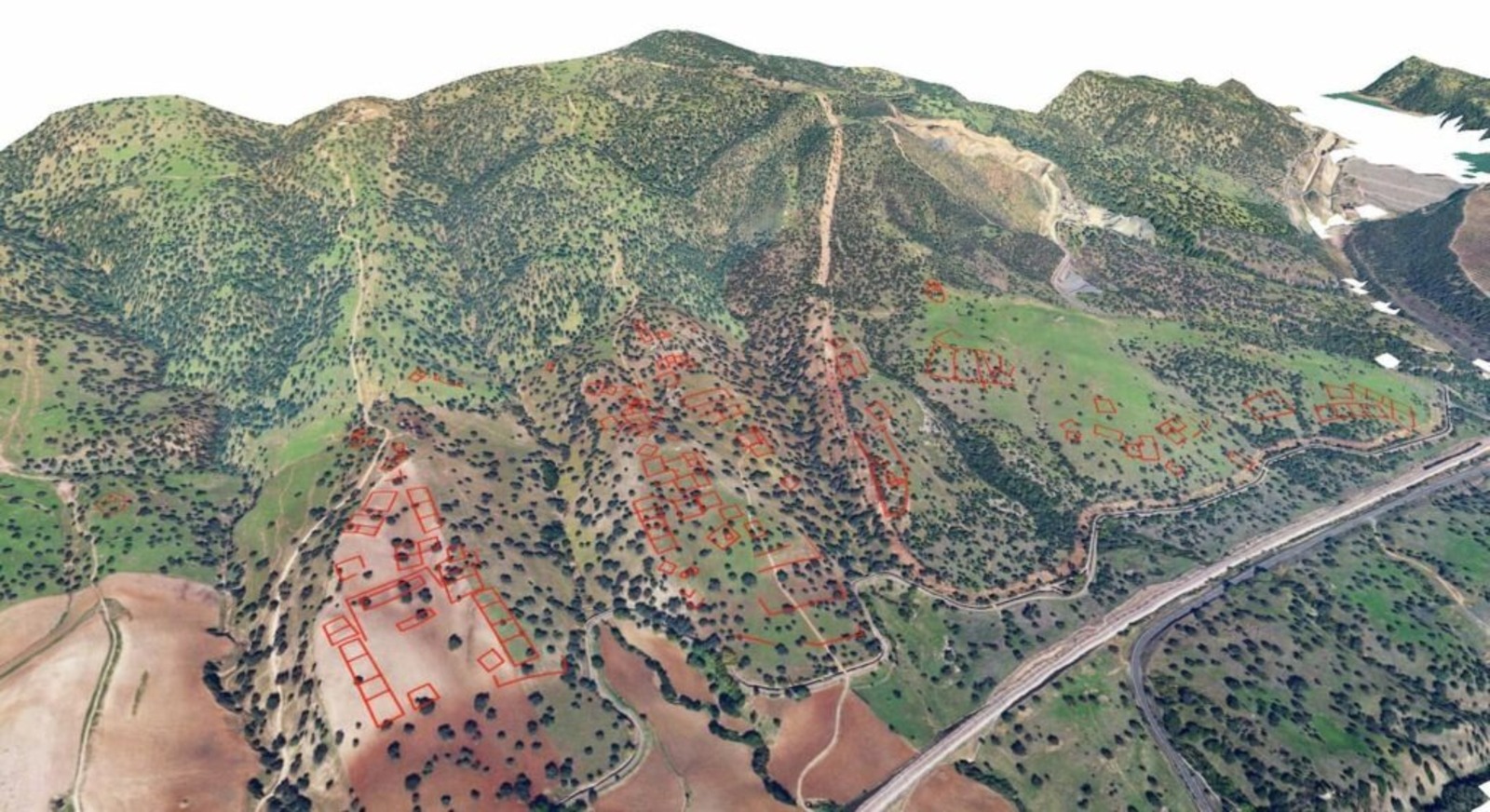
Study Using LIDAR Technology Identifies Area of 120 Hectares 12 Km from the Great Mosque of Córdoba as Likely Location of the Islamic Citadel Madinat al-Zahira Founded by Almanzor in the 10th Century
A study based on LIDAR technology has identified strong evidence about the location of Madinat al-Zahira, an ancient Islamic palace-city in Córdoba. The research points to an area of 120 hectares about 12 kilometers from the Great Mosque as a possible site of the Madinat al-Zahira, which has been lost for centuries.
For more than a thousand years, the precise location of the Madinat al-Zahira has remained one of the greatest enigmas of Islamic archaeology in Spain. The citadel was founded in the 10th century by Almanzor, also known as al-Mansur Ibn Abi Aamir.
The palace-city was built during the peak of Almanzor’s political power. At that time, the complex functioned as the political and administrative center of al-Andalus in the last decades of the Umayyad caliphate.
-
A Japanese governor single-handedly stalled the construction of the world’s fastest train for nine years, and only now has he agreed to allow a tunnel excavated at a depth of 1,400 meters.

-
Almost 1 billion euros, two gigafactories, and a million-dollar public investment, Chinese company aims to turn Spanish city into Europe’s new battery hub.

-
Advancement in the industry: Brazilian company creates ultralight material comparable to steel and paves the way for hydrogen cylinders up to 70% lighter, with a direct impact on logistics, the energy industry, and national competitiveness – learn about Forza Composites

-
In Brazil’s backyard: Tesla, by Elon Musk, announces official operations in Uruguay, where electric vehicles already make up 20% of new cars but still leaves out the largest market in the region.


Historical sources describe the Madinat al-Zahira as a monumental city planned to rival Madinat al-Zahra. The latter was also founded in the 10th century by Abd ar-Rahman III, the first caliph of al-Andalus.
Unlike Madinat al-Zahra, however, Madinat al-Zahira was completely destroyed after Almanzor’s downfall.
The disappearance of the city turned its location into a topographical mystery that has generated more than 20 hypotheses over the centuries.
LIDAR Technology Allows Identification of Possible Remains of Madinat al-Zahira
The new study was conducted by researcher Antonio Monterroso Checa from the University of Córdoba. The investigation utilized LIDAR technology, which stands for Light Detection and Ranging.
The system operates with a scanner that emits pulsed laser to measure distances between the sensor and surfaces on the ground. The time it takes for the pulse to return allows for calculating the distance based on the speed of light.
Thousands of these measurements are combined to create a detailed three-dimensional map of the analyzed area. This method allows detecting minimal variations in the terrain.
Digital Models Reveal Urban Patterns Hidden Beneath the Ground
The data used in the research was obtained from the National Geographic Institute of Spain. The technology allows identifying irregularities in the terrain even under dense vegetation.
Monterroso Checa analyzed high-resolution digital models generated by LIDAR. These models provide much more detail than previous analyses conducted in the region.
The interpretation of the data was carried out by combining historical analysis, medieval textual sources, and the study of urban morphology.
According to the researcher, this interdisciplinary methodology represents a shift from the speculative theories that dominated previous studies on the Madinat al-Zahira.
Area Near the Pendolillas Mountains Emerges as Main Candidate
The study identifies a large area located near the Pendolillas mountains in Córdoba as the most likely site of the ancient Madinat al-Zahira.
The region is approximately 12 kilometers from the Great Mosque of Córdoba. Anomalies have been detected in the terrain that extend for over a thousand meters.
These formations exhibit characteristics consistent with buried architectural structures.
Planned Urban Structure Appears in Three-Dimensional Images
According to the analyzed data, the anomalies indicate a clearly planned urban layout. The markings reveal possible square and rectangular constructions.
Additionally, the architectural organization appears to be distributed across plateaus with different heights. This arrangement indicates adaptation of the structures to the natural terrain of the region.
The estimated area of the possible palace-city is about 120 hectares. This size aligns with historical records associated with the city of Madinat al-Zahra.
This correlation reinforces the hypothesis that the Madinat al-Zahira was conceived as a twin citadel within the political and administrative system of the caliphate of al-Andalus.
With information from Estadão.